Estrella, Colorado

Last updated

Estrella, Colorado
Estrella, Colorado.JPG
Looking northwest on Estrella Road in Estrella, April 2018.
Usa edcp location map.svg
Red pog.svg
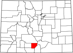
Estrella
Location of Estrella, Colorado.
USA Colorado location map.svg
Red pog.svg
Estrella
Estrella (Colorado)
Coordinates: 37°21′58″N105°55′28″W / 37.3661°N 105.9245°W / 37.3661; -105.9245 (Estrella, Colorado) [1]
Country United States
State Colorado
County Alamosa [2]
Government
  Type unincorporated community
  Body Alamosa County [2]
Elevation
[1]
7,569 ft (2,307 m)
Time zone UTC−07:00 (MST)
  Summer (DST) UTC−06:00 (MDT)
ZIP code [3]
Alamosa 81101
Area code 719
GNIS place ID 192916

Estrella is an unincorporated community in southern Alamosa County, Colorado, United States. [1] The community is a part of the Alamosa, CO Micropolitan Statistical Area.

Contents

History

Estrella is a name derived from Spanish meaning "star". [4] The unincorporated community has never had its own post office. [5] The Alamosa, Colorado, post office (ZIP code 81101) serves the area. [3]

Geography

Estrella is located in southern Alamosa County at coordinates 37°21′58″N105°55′28″W / 37.3661°N 105.9245°W / 37.3661; -105.9245 (Estrella, Colorado) and elevation 7,569 feet (2,307 m). [1]

See also

References

  1. 1 2 3 4 "Estrella, Colorado". Geographic Names Information System . United States Geological Survey, United States Department of the Interior . Retrieved December 4, 2025.
  2. 1 2 "Colorado Counties". Colorado Department of Local Affairs . Retrieved December 4, 2025.
  3. 1 2 "ZIP Code Lookup". United States Postal Service . Retrieved December 4, 2025.
  4. Dawson, John Frank. Place names in Colorado: why 700 communities were so named, 150 of Spanish or Indian origin. Denver, CO: The J. Frank Dawson Publishing Co. p. 20.
  5. Bauer, William H.; Ozment, James L.; Willard, John H. (1990). Colorado Post Offices 1859–1989. Golden, Colorado: Colorado Railroad Historical Foundation. ISBN   0-918654-42-4.