
Manatee County is a county in the U.S. state of Florida. As of the 2020 US Census, the population was 399,710. Manatee County is part of the North Port-Bradenton-Sarasota, Florida Metropolitan Statistical Area. Its county seat and largest city is Bradenton. The county was created in 1855 and named for the Florida manatee, Florida's official marine mammal. Features of Manatee County include access to the southern part of the Tampa Bay estuary, the Sunshine Skyway Bridge, and the Manatee River.
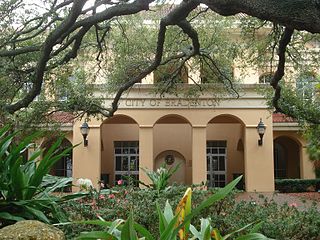
Bradenton is a city in and the county seat of Manatee County, Florida, United States. As of the 2020 census, the city's population is 55,698, up from 49,546 at the 2010 census. It is a principal city in the North Port-Bradenton-Sarasota, Florida Metropolitan Statistical Area. Downtown Bradenton is along the Manatee River and includes the Bradenton Riverwalk. Downtown Bradenton is also home to the Bishop Museum of Science and Nature.
Palmetto is a city in Manatee County, Florida, United States. As of the 2020 census, the population was listed as 13,323, up from 12,606 at the 2010 census. It is part of the North Port–Bradenton–Sarasota, Florida Metropolitan Statistical Area.

Stretching 148 miles (238 km) across the Florida peninsula, State Road 70 spans five Florida counties and straddles the northern boundaries of two more. Its western terminus is at US 41 south of Bradenton ; its eastern terminus is an intersection of Virginia Avenue and South Fourth Street in Fort Pierce.

Manatee High School is the oldest public high school in Bradenton, Florida, operated by the Manatee County School District.
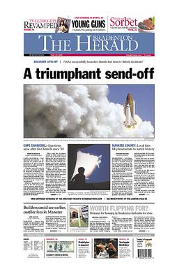
The Bradenton Herald is a newspaper based in Bradenton, Florida, in the United States.

The Sarasota metropolitan area is a metropolitan area located in Southwest Florida. The metropolitan area is defined by the Office of Management and Budget (OMB) as the North Port–Bradenton–Sarasota Metropolitan Statistical Area, a metropolitan statistical area (MSA) consisting of Manatee County and Sarasota County. The principal cities listed by the OMB for the MSA are North Port, Bradenton, Sarasota, Lakewood Ranch, and Venice. At the 2020 census, the MSA had a population of 833,716. The Census Bureau estimates that its population was 891,411 in 2022.
Myakka City is an unincorporated community in southeastern Manatee County, Florida, United States. It lies along State Road 70 near the city of Bradenton, the county seat of Manatee County. Its elevation is 43 feet (13 m), and it is located at 27°20′59″N82°9′41″W. Although Myakka is unincorporated, it has a post office, with the ZIP code of 34251; the ZCTA for ZIP code 34251 had a population of 6,351 at the 2010 census. up from 4,239 in 2000.
Irmulco is a former logging town in Mendocino County, California. It was located on the California Western Railroad 12 miles (19 km) north-northeast of Comptche, at an elevation of 436 feet.
Edgeville was a former company town and railway stop located southeast of Myakka City in Manatee County, Florida, United States. Turpentine was made in the area and later a crate manufacturer was located in Edgeville. A school for African American children was established in the community.
The Tampa Southern Railroad was a subsidiary of the Atlantic Coast Line Railroad (ACL) originally running from Uceta Yard in Tampa south to Palmetto, Bradenton, and Sarasota with a later extension southeast to Fort Ogden in the Peace River valley built shortly after. It was one of many rail lines completed during the Florida land boom of the 1920s. Most of the remaining trackage now serves as CSX Transportation's Palmetto Subdivision. Another short portion just east of Sarasota also remains that is now operated by Seminole Gulf Railway.
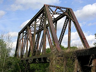
The East and West Coast Railway was a railroad line running from Bradenton on the west coast of Florida southeast to Arcadia in the Peace River valley. Despite its name, the line never went all the way to the east coast of Florida. The line was often used to transport mail, lumber, grain and other commodities.
Manhattan was a proposed city in a development that was located in northern Manatee County, Florida near the present-day town of Parrish during the Florida land boom in the 1920s. The town was intended to be the centerpiece of an agricultural community called Manatee River Park Estates.
Oak Knoll is an unincorporated area in Manatee County, Florida, in the United States.
Verna is an unincorporated area in Manatee County and Sarasota County, Florida, United States.
Elwood Park is an unincorporated area in Manatee County, Florida, United States.
Cedar Hammock is an unincorporated area in Manatee County, Florida, in the United States. Flanked by Bradenton to the north and Oneco to the south, Cedar Hammock was a hardwood hammock which became a popular location for truck farming in the early 20th century.
Sandy is an unincorporated area in Manatee County, Florida, United States. The community was previously known as Sandy Branch and Stephen.
Lorraine is an unincorporated area located in Manatee County, Florida.
The Seaboard Air Line Railroad's Sarasota Subdivision was a rail line that ran from the company's main line at Turkey Creek south to Palmetto, Bradenton, Sarasota, and Venice. The line was built in phases from 1901 to 1911.


