
Buldhana district is located in the Amravati division of Maharashtra, India. It is situated at the western border of Vidarbha region and is 500 km away from the state capital, Mumbai. The district has towns and cities like Shegaon, Malkapur, Khamgaon, Lonar and Chikhli. It is surrounded by Madhya Pradesh in the north, Akola, Washim, and Amravati districts on the east, Jalna district on the south, and Jalgaon and Aurangabad districts on the west. Khamgaon is the largest city in the district.

Chhindwara district is one of the major districts of Madhya Pradesh state of India, and Chhindwara town is the district headquarters. Chhindwara is the largest district in Madhya Pradesh with an area of 11,815 square km. The district is part of Jabalpur division.

Seoni District is a district of Madhya Pradesh state in central India. The town of Seoni is the district headquarters.

Seoni is a city and a municipality in Seoni district in the Indian state of Madhya Pradesh. This tribal household dominated district was formed in the year 1956. Rudyard Kipling used the forests in the vicinity of Seoni, or as was spelled during British colonial rule, Seeonee, as the setting for the Mowgli stories in The Jungle Book and The Second Jungle Book (1894–1895), although the area is not an actual rainforest. Seoni is a city where tributary of the river Godavari, the Wainganga, originates. Seoni is reachable by trains & road, major adjacent cities are Nagpur and Jabalpur. The National Highway 44 north–south corridor crosses from Seoni. Seoni Railway Station serve as the primary transportation hub for Seoni district and connect Seoni city to National capital and State capital (Bhopal) directly via express trains .The nearest airport is Nagpur (130 km); a small airport (air-strip) is available at Seoni near Sukhtara village for landing charter airplanes/helicopters. The Wainganga is a river in India originating in the Mahadeo Hills in Mundara near the village Gopalganj in Seoni, Madhya Pradesh. It is a key tributary of the Godavari. The river flows south in a winding course through the states of Madhya Pradesh and Maharashtra, roughly 579 km (360 mi). After joining the Wardha River, the united stream, which is known as the Pranahita River, empties into the Godavari River at Kaleshwaram, Telangana.

Nagpur district is a district in the Vidarbha region of Maharashtra state in central India. The city of Nagpur is the district administrative centre. The district is part of Nagpur Division.

Katol is a city and a municipal council in Nagpur district of Maharashtra state, India. It is the administrative headquarter of Katol taluka, one of the 14 talukas of this district. Being located in orange belt it is a major centre for orange trading.
Anjangaon is a city and a municipal council in Amravati district in the state of Maharashtra, India. Anjangaon City got the status of Municipal Council in 1930. It is the first municipal council established in Amravati district and the second biggest council as well. Anjangaon Surji Tehsil was established in 1981. It is technically made up of two main zones, Anjangaon and Surji, on either side of Shahanur River, and is called Anjangaon-Surji in combination. It is called a "Banana Hub of Vidarbha" as it is a large producer of bananas and a hub of medicinal plants - Piper longum and Safed musali.

Kalameshwar-Bramhani is a city and a municipal council also a major Industrial hub in Nagpur district in the Indian state of Maharashtra. It is connected to National Highways NH-353I, NH-353J & NH-547E.
Narkhed is a town and a municipal council in Nagpur district in the Indian state of Maharashtra. It is about 87 km north-west of Nagpur. It is the administrative headquarters of Narkhed taluka, one of the 14 talukas of this district. It is located in the "orange belt" and is a major center for orange-trading.
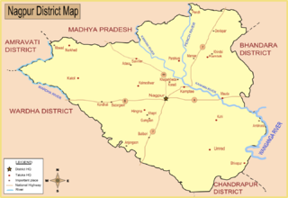
Saoner is a city and tehsil headquarters in north part of Nagpur district in state of Maharashtra, India. The town is governed by Savner municipal council. It is 36 kilometres (22 mi) from Nagpur city. Saoner is located on the bank of Kolar River. It is historically and mythologically important.

The word Maharashtra, the land of the mainly Marathi-speaking people, appears to be derived from Maharashtri, an old form of Prakrit. Some believe that the word indicates that it was the land of the Mahars and the Rattas, while others consider it to be a corruption of the term 'Maha Kantara', a synonym for 'Dandakaranya'. Maharashtra is the third largest state in India after Rajasthan and Madhya Pradesh. It covers an area of 307,713 km2 and is bordered by the states of Madhya Pradesh to the north, Chhattisgarh to the east, Telangana to the southeast, Karnataka to the south and Goa to the southwest. The state of Gujarat lies to the northwest, with the Union territory of Dadra and Nagar Haveli sandwiched between the borders. Maharashtra moosd,omadomcopm kooc has coastline of 720 km.The Arabian Sea makes up Maharashtra's west coast. Maharashtra consists of two major relief divisions. The plateau is a part of the Deccan tableland and the Konkan coastal strip abutting on the Arabian Sea.
Totladoh dam, is a gravity dam on the Pench river near Ramtek in Nagpur district in the state of Maharashtra and adjoining Madhya Pradesh in India.

Ramtek Dam, is an earthfill dam on Sur River near Ramtek, Nagpur district in the state of Maharashtra in India.
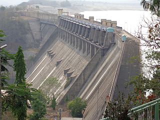
Kamthikhairy Dam, also called Pench Dam, is on the Pench river near Parshivni in the state of Maharashtra, India. The dam was constructed for irrigation, and supplies water to two districts of Maharashtra, Nagpur and Bhandara. The dam is located in the West Pench National Park Range, surrounded by forested hills, and is 54 km north of Nagpur.
Patansavangi is a panchayat village in Maharashtra State, India. Administratively, Patansavangi is under the Saoner Taluk of Nagpur District in Maharashtra, although earlier (1908) it had been part of the larger Ramtek taluka. It lies on the left (east) bank of the Kolar River, just upstream from its confluence with the Chandrabhaga Nadi. Patansavangi is 13 km by road southeast of the town of Saoner (Savner) and 25 km by road northwest of the town of Nagpur.

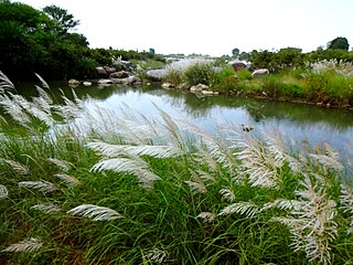
The Kolar River is a river of Nagpur district, Maharashtra, India, flowing southeast from above the town of Saoner to its juncture with the Kanhan River. It is in the Godavari river basin. The Kolar River forms the boundary between Saoner taluka and Ramtek taluka.

The Pench River is an Indian tributary of the Kanhan River. It originates in the Chhindwara district of Madhya Pradesh and flows across Pench National Park, which is a reserve for the Tiger Project of India.

The Kanhan River is an important right bank tributary of the Wainganga River draining a large area lying south of Satpura range in central India. Along its 275 km run through the Indian States of Maharashtra & Madhya Pradesh, it receives its largest tributary - Pench River, a major water source for the metropolis of Nagpur.
The Kuldhara River is a river in Chhindwara District of Madhya Pradesh state, India. It is a tributary of the Pench and has a course of about fifty miles.

