Related Research Articles

The Yukon River is a major watercourse of northwestern North America. From its source in British Columbia, it flows through Canada's territory of Yukon. The lower half of the river continues westward through the U.S. state of Alaska. The river is 3,190 kilometres (1,980 mi) long and empties into the Bering Sea at the Yukon–Kuskokwim Delta. The average flow is 6,400–7,000 m3/s (230,000–250,000 cu ft/s). The total drainage area is 854,700 km2 (330,000 sq mi), of which 323,800 km2 (125,000 sq mi) lies in Canada. The total area is more than 25% larger than Texas or Alberta.
Indian River may refer to:

Bennett Lake is a lake in the Province of British Columbia and Yukon Territory in northwestern Canada, at an elevation of 656 m (2,152 ft). It is just north of the border with the United States state of Alaska, near the Alaskan port of Skagway. The lake has an area of either 90.68 or 96.8 km2. The average depth is 61.9 m (203 ft) and the maximum depth is 123 m (404 ft).

The Liard River of the North American boreal forest flows through Yukon, British Columbia and the Northwest Territories, Canada. Rising in the Saint Cyr Range of the Pelly Mountains in southeastern Yukon, it flows 1,115 km (693 mi) southeast through British Columbia, marking the northern end of the Rocky Mountains and then curving northeast back into Yukon and Northwest Territories, draining into the Mackenzie River at Fort Simpson, Northwest Territories. The river drains approximately 277,100 km2 (107,000 sq mi) of boreal forest and muskeg.

The Moira River is a river in Hastings County in eastern Ontario, Canada. It travels from its source in the centre of the county to the Bay of Quinte at the county seat Belleville.

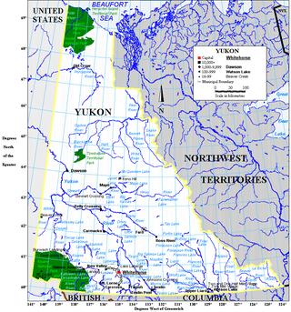
Yukon is in the northwestern corner of Canada and is bordered by Alaska, British Columbia and the Northwest Territories. The sparsely populated territory abounds with natural scenery, snowmelt lakes and perennial white-capped mountains, including many of Canada's highest mountains. The territory's climate is Arctic in territory north of Old Crow, subarctic in the region, between Whitehorse and Old Crow, and humid continental climate south of Whitehorse and in areas close to the British Columbia border. Most of the territory is boreal forest with tundra being the main vegetation zone only in the extreme north and at high elevations.

The Stikine Country, also referred to as the Stikine District or simply "the Stikine", is one of the historical geographic regions of the Canadian province of British Columbia, located inland from the central Alaska Panhandle and comprising the basin of the Stikine River and its tributaries. The term Stikine–Iskut is also fairly common to describe the area, and references the Iskut River, the Stikine's largest tributary and describable as its south fork.

The Tahltan River is a tributary of the Stikine River in northwest part of the province of British Columbia, Canada. It flows generally east and southeast about 95 km (59 mi) to join the Stikine River at Tahltan, British Columbia. The lower Tahltan River marks the boundary between the Tahltan Highland and the Nahlin Plateau, both of which are part of the larger Stikine Plateau region.

The Indian River is a river in Yukon, Canada. It is in the Bering Sea drainage basin and is a right tributary of the Yukon River.
Partridge Creek is a creek in the Moira River and Lake Ontario drainage basins in Hastings and Lennox and Addington Counties, Ontario, Canada.
The Wolf River is a river in Yukon, Canada. It is in the Bering Sea drainage basin and is a left tributary of the Nisutlin River.
The Nares River is a river in the Yukon and British Columbia, Canada. It is in the Bering Sea drainage basin, is a tributary of Tagish Lake, and is named for George Nares, a naval officer.
Partridge Lake is a lake in the Yukon and British Columbia, Canada that is part of the Bering Sea drainage basin. The primary inflow, at the south, and outflow, at the north, is the Partridge River, which flows via Bennett Lake, the Nares River, Tagish Lake, the Tagish River and the Yukon River to the Bering Sea. A secondary inflow, at the southwest, is Jones Creek.
Kakuchuya Creek, historically called the Kakuchuya River, is a tributary of the Dudidontu River and part of the Taku River watershed in northwest part of the province of British Columbia, Canada.
The Namewaminikan River is a river in Thunder Bay District in northwestern Ontario, Canada. It is in the Great Lakes Basin and is a tributary of Lake Nipigon.

The Bell-Irving River is a tributary of the Nass River in northwestern British Columbia, Canada. It originates in the Sacred Headwaters region, and flows about 165 km (103 mi) south to the Nass River. It course lies between the Oweegee Range of the Skeena Mountains to the east and the Boundary Ranges of the Coast Mountains to the west.
The Albreda River is a river in Thompson-Nicola Regional District and the Regional District of Fraser-Fort George in the Interior region of British Columbia, Canada. It is in the Pacific Ocean drainage basin and is a left tributary of the North Thompson River. The nearest communities to the mouth of the creek on British Columbia Highway 5 are Blue River 42 kilometres (26 mi) south and Valemount 48 kilometres (30 mi) north; the mouth of the river is at a point where the North Thompson River, arriving downstream from its source, turns 90° right and heads south.
Mess Creek, formerly known as Mestua, is a tributary of the Stikine River in northwestern British Columbia, Canada. It flows north and northwest for about 110 km (68 mi), through a lake and a gorge to join the Stikine River, which in turn flows southwest across the Canada–United States border into Alaska where it empties into various straits of the Inside Passage. The northern half of Mess Creek forms a western boundary of Mount Edziza Provincial Park which lies within the traditional territory of the Tahltan people.
Bourgeaux Creek is a tributary of the Little Iskut River and part of the Stikine River watershed in northwest part of the province of British Columbia, Canada. It flows generally east for roughly 17 km (11 mi) to join the Little Iskut River, a tributary of the Iskut River, which in turn is the largest tributary of the Stikine River. Gerlib Creek joins Bourgeaux Creek about 5 km (3.1 mi) upstream of Bourgeaux's confluence with the Little Iskut River.
References
- ↑ "Partridge River". Geographical Names Data Base . Natural Resources Canada . Retrieved 2014-07-28.