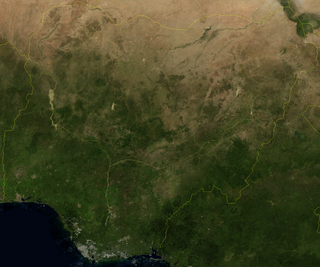
Nigeria is a country in West Africa. It shares land borders with the Republic of Benin to the west, Chad and Cameroon to the east, and Niger to the north. Its coast lies on the Gulf of Guinea in the south and it borders Lake Chad to the northeast. Notable geographical features in Nigeria include the Adamawa Plateau, Mambilla Plateau, Jos Plateau, Obudu Plateau, the Niger River, Benue River, and Niger Delta.
Yola, meaning 'Great Plain' or 'Vast Plain Land', is a large city, capital city and administrative centre of Adamawa State, Nigeria. It is located on the Benue River, and it has a population of over 336,648 (2010). Yola is split into two parts. The old town of Yola where the Lamido resides is the traditional city and the new city of Jimeta is the administrative and commercial centre. They are generally referred to as Yola.

Asaba is the capital of Delta State, Nigeria. A rapidly growing city, it is located at the western bank of the Niger River, in the Oshimili South Local Government Area. Asaba had a population of 149,603 as at the 2006 census, and a fast growing metropolitan population of over half a million people.

Bayelsa is a state in the South South region of Nigeria, located in the core of the Niger Delta. Bayelsa State was created in 1996 and was carved out from Rivers State, making it one of the newest states in the federation. The capital, Yenagoa, is susceptible to high risk of annual flooding. It shares a boundary with Rivers State to the east and Delta State to the north across the Niger River for 17 km and the Forçados River for 198 km, with the waters of the Atlantic Ocean dominating its southern borders. It has a total area of 10,773 square kilometres (4,159 sq mi). The state comprises eight local government areas: Ekeremor, Kolokuma/Opokuma, Yenagoa, Nembe, Ogbia, Sagbama, Brass and Southern Ijaw. The state is the smallest in Nigeria by population as of the 2006 census. Being in the Niger Delta, Bayelsa State has a riverine and estuarine setting, with bodies of water within the state preventing the development of significant road infrastructure.
Yenagoa is a Local Government Area and capital city of Bayelsa State, southern Nigeria. It is located at the southern part of the country at coordinates 4°55′29″N6°15′51″E.
Ogoja is a Local Government Area in Cross River State, Nigeria. Its headquarters is Ogoja town in the northeast of the area near the A4 highway at 6°39′17″N8°47′51″E.
Kontagora is a major town on the south bank of the Kontagora River in north-west Niger State, Nigeria. It is the capital city of the Kontagora Emirate. The former Niger state governor, Alhaji Abubakar Sani Bello hails from Kontagora. On December 15, 1995, the Roman Catholic Apostolic Vicariate of Kontagora was established here. St Michael's Cathedral is the seat of the apostolic vicar.
Suleja is a city in Niger State, Nigeria, pop. (2016) local government area, 260,240, just north of Abuja, capital of the Suleja Emirate. It is sometimes confused with the nearby city of Abuja, due to its proximity, and the fact that it was originally called Abuja before the Nigerian government adopted the name from the then Emir Sulayman Bal for its new federal capital in 1976.
Bida is a Local Government Area in Niger State, Nigeria and a city on the A124 highway which occupies most of the area.

Gboko is a Local Government Area in Benue state, North-central Nigeria. It is headquartered in the town of Gboko.
Udu is a Local Government Area in Delta State, Nigeria with its local government headquarters at Otor-Udu. It has a population estimate of approximately 100,000 people. It is one of the Urhobo kingdoms, has its own king, or ovie. The town is about 10 minutes drive from Osubi Airport

Burutu is a Local Government Area in Delta State, Nigeria. It lies on the coast of the Niger Delta on two sides of the Forcados River, a channel of the River Niger, 30 kilometres upstream from the Bight of Benin. It has served as a link between river transport and the sea when the Royal Niger Company established a base there in the late 19th century. People living in this region are mostly of the Izon ethnicity.
Ankpa is a Local Government Area in Kogi State, Nigeria. Its headquarters are in the town of Ankpa on the A233 highway in the west of the area at7°22′14″N7°37′31″E.
Musawa is a Local Government Area in Katsina State, Nigeria. Its headquarters is in the town of Musawa.
Kauru is a Local Government Area in southern Kaduna State, Nigeria. The area is 3,186 km2. Its headquarters are in the town of Kauru. The postal code of the area is 811.
Olorunsogo is a Local Government Area in Oyo State, Nigeria. Its headquarters are in the town of Igbeti.
Anka is a Local Government Area in Zamfara State, Nigeria. Its headquarters is in the town of Anka at 12°06′30″N5°56′00″E.

Potiskum is a local government area and city in Yobe State, Nigeria. It's the most populous and fastest growing city in Yobe State. Of the native languages in Yobe State, Potiskum is home to several major groups which include the Karai-Karai, Bolewa and Ngizim and Hausa-Fulani. It is on the A3 highway at 11°43′N11°04′E. It has an area of 559 square kilometres (216 sq mi).
Fika is a Local Government Area in Yobe State, Nigeria. Its headquarters are in the town of Fika in the south of the area at 11°17′00″N11°18′29″E.
Ukwuani is a Local Government Area of Delta State, Nigeria. Its headquarters are located in Obiaruku.


