
Trinidad and Tobago is an archipelagic republic in the southern Caribbean between the Caribbean Sea and the North Atlantic Ocean, northeast of Venezuela. They are southeasterly islands of the Lesser Antilles, Monos, Huevos, Gaspar Grande, Little Tobago, and St. Giles Island. Trinidad is 11 km (6.8 mi) off the northeast coast of Venezuela and 130 km (81 mi) south of the Grenadines. The island measures 4,768 km2 (1,841 sq mi) in area with an average length of 80 km (50 mi) and an average width of 59 km (37 mi). The island appears rectangular in shape with three projecting peninsular corners. Tobago is 30 km (19 mi) northeast of Trinidad and measures about 298 km2 (115 sq mi) in area, or 5.8% of the country's area, 41 km (25.5 mi) in length and 12 km (7.5 mi) at its greatest width. The island is cigar-shaped in appearance, with a northeast–southwest alignment.

Isla de Aves, or Aves Island, is a Federal Dependency of Venezuela. It has been the subject of numerous territorial disputes with the United States, neighbouring independent islands such as Dominica, and European states controlling their nearby dependent islands, such as the Netherlands and the United Kingdom.
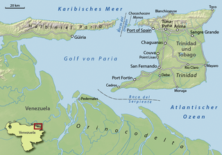
The Gulf of Paria is a 7,800 km2 (3,000 sq mi) shallow semi-enclosed inland sea located between the island of Trinidad and the east coast of Venezuela. It separates the two countries by as little as 15 km at its narrowest and 120 km at its widest points. The tides within the Gulf are semi-diurnal in nature with a range of approximately 1m. The Gulf of Paria is considered to be one of the best natural harbors on the Atlantic coast of the Americas. The jurisdiction of the Gulf of Paria is split between Trinidad and Venezuela with Trinidad having control over approximately 2,940 km2 (1,140 sq mi) (37.7%) and Venezuela the remainder (62.3%).

The Bolivarian Republic of Venezuela is a federation made up of twenty-three states, a Capital District and the Federal Dependencies, which consist of many islands and islets in the Caribbean Sea. Venezuela claims the disputed Essequibo territory as one of its states, which it calls Guayana Esequiba, but the territory is controlled by Guyana as part of six of its regions.

The Federal Dependencies of Venezuela encompass most of Venezuela's offshore islands in the Caribbean Sea and the Gulf of Venezuela, excluding those islands that form the State of Nueva Esparta and some Caribbean coastal islands that are integrated with nearby states. These islands, with a total area of 342 square kilometres, are sparsely populated – according to the preliminary results of the 2011 Census only 2,155 people live there permanently, with another hundred from Margarita Island who live there seasonally to engage in fishing. Local government is officially under the authority of Central government in Caracas, although de facto power is often held by the heads of the sparse and somewhat isolated communities that decorate the territories.

Chacachacare is an island in the Republic of Trinidad and Tobago, located at 10° 41' north latitude and 61° 45' west longitude. The island is 360 hectares in area.

The Bocas del Dragón are the series of straits separating the Gulf of Paria from the Caribbean Sea. There are four Bocas, from west to east:

La Orchila Island is an island and a military base off the coast of Venezuela, north of Caracas. It has numerous beaches, including one where the sand is markedly pink.

The Islas Los Frailes are an archipelago of rock islets with sparse scrub vegetation belonging to the Federal dependencies of Venezuela, part of Venezuela.

The Los Roques Archipelago is a federal dependency of Venezuela consisting of approximately 350 islands, cays, and islets in a total area of 40.61 km2 (15.68 sq mi). The archipelago is located 128 km (80 mi) directly north of the port of La Guaira, in the Caribbean Sea.

La Tortuga Island is an uninhabited island of Venezuela, the largest in the Federal Dependencies of Venezuela. It is part of a group of islands that include the Tortuguillos and Cayo Herradura. Isla La Tortuga has an area of 156 km2 (60 sq mi).
The Las Aves Archipelago is a pristine archipelago in the Caribbean Sea, and is a part of the Federal Dependencies of Venezuela. It is located north of the Venezuelan states of Aragua and Carabobo, between the Dutch island Bonaire in the west, and the Los Roques Archipelago in the east, at 12°00′N67°40′W. The prime economic importance of the islands lies in fishing. "Las Aves" translates to "The Birds" in English.
The Los Hermanos Archipelago is a chain of seven rocky barren islets that is part of the Federal Dependencies of Venezuela, at 11°45′N64°25′W.

Blanquilla is an island, one of the Federal Dependencies of Venezuela, located in the south-eastern Caribbean Sea about 293 km north-east of Caracas. It is a popular location for divers, as well as famous for its white sand beaches, for which it is named.
The Los Monjes islands is a federal dependency of Venezuela are located to the northwest 80 kilometres of the Gulf of Venezuela, 34.8 kilometres off the coast of Guajira Peninsula at the border between Colombia and the Venezuelan state of Zulia.

Gasparillo is a small island in the Republic of Trinidad and Tobago. It is one of the Bocas Islands, which lie in the Bocas del Dragón between the main island of Trinidad and Venezuela. The island is currently uninhabited.
Los Testigos Islands are a group of islands in the southeastern Caribbean Sea. They are a part of the Dependencias Federales of Venezuela.
La Sola Island is a small island in the southeastern Caribbean Sea. The island is a part of the Dependencias Federales of Venezuela.
The Gulf of Paria crossing is a hypothetical bridge or tunnel spanning the Gulf of Paria that would connect the island of Trinidad and South America.


