Amazonas Federal Territory

Last updated
Amazonas Federal Territory
Territorio Federal Amazonas
Federal Territory of Venezuela
1864–1992
Amazonas in Venezuela (+claimed).svg
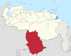
Location of the Amazonas Federal Territory (red) in Venezuela.
Capital San Fernando de Atabapo (1864–1924)
Maroa (1881–1893)
Puerto Ayacucho (1924–1991)
Area 
 1881 [1]
350,000 km2 (140,000 sq mi)
Population 
 1881 [2]
45,200
  Type Federal Territory of Venezuela
History 
 Established
1864
  Statehood
23 July 1992
Preceded by
Succeeded by
Blank.png Amazonas Province
Amazonas State Flag of Amazonas Indigenous State.svg

The Amazonas Federal Territory is the name by which the current Amazonas State of Venezuela was known until 1992. [3]

Contents

History

The origins of the Amazon Federal Territory date back to the Río Negro canton of the Guayana Province, which covered an area similar to the current state and part of the Colombian departments of Vichada and Guainía, and with capital in San Fernando de Atabapo. [4]

In 1856, it was decided to elevate this canton into a province separate from that of Guayana with the name of Province of Amazonas  [ es ]. When the Federal Revolution came to power under the command of Juan Crisóstomo Falcón in 1864, the name was changed to Amazonas Federal Territory made up of the departments of San Fernando de Atabapo, San Carlos and Maroa. [4]

The political-administrative changes promoted by Antonio Guzmán Blanco, meant that from 1881 to 1893 said territory was divided into two; the Amazonas Federal Territory with capital in Maroa, and the Alto Orinoco Federal Territory  [ es ] retaining San Fernando de Atabapo as capital. In 1893, the name "Amazon Federal Territory" was resumed with capital again in San Fernando de Atabapo until 1928, when it was decided to move the capital to Puerto Ayacucho to make it more accessible to the rest of Venezuela. On 23 July 1992, the Congress of the Republic, currently the National Assembly, elevated the category of Federal Territory to state. [4]

Territorial division

The Amazonas Federal Territory was divided into departments for its administration; towards the end of the territory's existence these were: [5]

See also

Related Research Articles

<span class="mw-page-title-main">Orinoco</span> River in Venezuela and Colombia

The Orinoco is one of the longest rivers in South America at 2,250 kilometres (1,400 mi).

<span class="mw-page-title-main">Rio Negro (Amazon)</span> Tributary of the Amazon River

The Rio Negro, or Guainía as it is known in its upper part, is the largest left tributary of the Amazon River, the largest blackwater river in the world, and one of the world's ten largest rivers by average discharge.

San Fernando may refer to:

<span class="mw-page-title-main">Amazonas (Venezuelan state)</span> State of Venezuela

Amazonas State is one of the 23 states into which Venezuela is divided. It covers nearly a fifth of the area of Venezuela, but has less than 1% of Venezuela's population.

<span class="mw-page-title-main">Bolívar (state)</span> State in Venezuela

Bolívar is one of the 23 states of Venezuela. The state capital city is Ciudad Bolívar and the largest city is Ciudad Guayana. Bolívar State covers a total surface area of 242,801 km2 (93,746 sq mi) and as of the 2011 census, had a population of 1,410,964. The state contains Angel Falls.

<span class="mw-page-title-main">Puerto Ayacucho</span> Place in Amazonas, Venezuela

Puerto Ayacucho is the capital and largest city of Amazonas State in Venezuela. Puerto Ayacucho is located across the Orinoco River from the Colombian village of Casuarito.

<span class="mw-page-title-main">States of Venezuela</span> Federated states of the Bolivarian Republic of Venezuela

The Bolivarian Republic of Venezuela is a federation made up of twenty-three states, a Capital District and the Federal Dependencies, which consist of many islands and islets in the Caribbean Sea. Venezuela claims the disputed Essequibo territory as one of its states, which it calls Guayana Esequiba, but the territory is controlled by Guyana as part of six of its regions.

<span class="mw-page-title-main">Maroa, Amazonas</span> Place in Amazonas, Venezuela

Maroa is a town in the southern Venezuelan state of Amazonas. This town is the shire town of the Maroa Municipality and, according to the 2001 Venezuelan census, the municipality has a population of 890.

<span class="mw-page-title-main">Municipalities of Venezuela</span> Subdivisions of the States of Venezuela

Municipalities of Venezuela are subdivisions of the States of Venezuela. There are 335 municipalities dividing the 23 states and the Capital District.

<span class="mw-page-title-main">Guayana Region, Venezuela</span> Administrative region of eastern Venezuela

The Guayana Region is an administrative region of eastern Venezuela.

<span class="mw-page-title-main">Captaincy General of Venezuela</span> Administrative district within the Spanish Empire (1777–1834)

The Captaincy General of Venezuela, was an administrative district of colonial Spain, created on September 8, 1777, through the Royal Decree of Graces of 1777, to provide more autonomy for the provinces of Venezuela, previously under the jurisdiction of the Audiencia of Santo Domingo and then the Viceroyalty of New Granada. It established a unified government in political (governorship), military, fiscal (intendancy), ecclesiastical (archdiocese) and judicial (audiencia) affairs. Its creation was part of the Bourbon Reforms and laid the groundwork for the future nation of Venezuela, in particular by orienting the province of Maracaibo towards the province of Caracas.

<span class="mw-page-title-main">Atabapo Municipality</span> Municipality in Amazonas, Venezuela

The Atabapo Municipality is one of the seven municipalities (municipios) that makes up the southern Venezuelan state of Amazonas and, according to the 2011 census by the National Institute of Statistics of Venezuela, the municipality has a population of 9,169. The town of San Fernando de Atabapo is the municipal seat of the Atabapo Municipality.

<span class="mw-page-title-main">Maroa Municipality</span> Municipality in Amazonas, Venezuela

The Maroa Municipality is one of the seven municipalities (municipios) that makes up the southern Venezuelan state of Amazonas and, according to the 2011 census by the National Institute of Statistics of Venezuela, the municipality had a population of 2,029. The town of Maroa is the shire town of the Maroa Municipality.

<span class="mw-page-title-main">Atures Municipality</span> Municipality in Amazonas, Venezuela

The Atures Municipality is one of the seven municipalities (municipios) that makes up the southern Venezuelan state of Amazonas and, according to the 2011 census by the National Institute of Statistics of Venezuela, the municipality has a population of 104,228. The city of Puerto Ayacucho is the shire town of the Atures Municipality.

<span class="mw-page-title-main">Guayana Province</span> Former province of Spanish Colonial Venezuela and independent Venezuela

Guayana Province (1585−1864) was a former province of Spanish Colonial Venezuela and independent Venezuela, located in the Guyana region of northeastern South America.

<span class="mw-page-title-main">Apostolic Vicariate of Puerto Ayacucho</span> Latin Catholic ecclesiastical jurisdiction in Venezuela

The Apostolic Vicariate of Puerto Ayacucho is a Latin Church missionary ecclesiastical jurisdiction or apostolic vicariate of the Catholic Church in Venezuela.

<span class="mw-page-title-main">Colombia–Venezuela border</span> International border

The Colombia–Venezuela border is an international border of 2219 kilometers (1378 mi) between Colombia and Venezuela, with a total of 603 milestones that demarcate the line. It is the longest border of both Colombia and Venezuela.

Carlos Santana Tovar was a Venezuelan businessman, government official and politician. In the mid-20th century he was a prominent rubber trader and local official in San Carlos de Río Negro, and represented the Federal Territory of Amazonas in the Constituent Assembly during the rule of Marcos Pérez Jiménez.

<span class="mw-page-title-main">Delta Amacuro Federal Territory</span> Venezuelan federal territory (1884–1991)

The Delta Federal Territory, later Delta Amacuro, is the name by which the current Delta Amacuro State of Venezuela was known until 1991.

References

  1. Claudio Alberto Briceño Monzón, José Leonardo Briceño Monzón. "Desenmarañando la administración político territorial de Venezuela en el siglo XIX" (PDF) (in Spanish). Presente y Pasado. Revista de Historia. p. 8 (186). Retrieved 1 January 2024.
  2. Claudio Alberto Briceño Monzón, José Leonardo Briceño Monzón. "Desenmarañando la administración político territorial de Venezuela en el siglo XIX" (PDF) (in Spanish). Presente y Pasado. Revista de Historia. p. 8 (186). Retrieved 1 January 2024.
  3. "Estado Amazonas" (PDF) (in Spanish). Canaima Educativa. Archived from the original (PDF) on 17 February 2015. Retrieved 1 January 2024.
  4. 1 2 3 "Historia del Estado Amazonas" (in Spanish). Viajando por Venezuela. Archived from the original on 23 January 2013. Retrieved 1 January 2024.
  5. "Ley Orgánica de los Territorios Federales" (PDF) (in Spanish). Justia Venezuela. Retrieved 1 January 2024.