
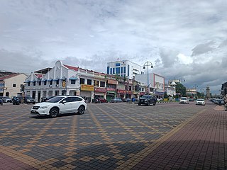
Pattani is one of the southern provinces of Thailand. Neighboring provinces are Narathiwat, Yala, and Songkhla. Its capital is the town of Pattani.

Surat Thani is a city in Amphoe Mueang Surat Thani, Surat Thani Province, southern Thailand. It lies 651 km (405 mi) south of Bangkok. It is the capital of Surat Thani Province. The city has a population of 132,040 (2019), and an area of 68.97 km2 (26.63 sq mi). The city's population density is 1,914 inhabitants per km2.

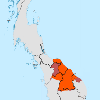
PataniDarussalam is a historical region and sultanate in the Malay Peninsula. It includes the southern Thai provinces of Pattani, Yala (Jala), Narathiwat (Menara), parts of Songkhla (Singgora) and also parts of Malaysia modern state Kelantan and Besut district in state of Terengganu. Its capital was the town of Patani.

Raja Perempuan BesarTengku Budriah binti Almarhum Tengku Ismail was the Raja Perempuan of Perlis and the third Raja Permaisuri Agong of Malaysia as the wife of Tuanku Syed Putra Jamalullail.
Sungai Petani is a town in Kuala Muda District, Kedah, Malaysia. Sungai Petani is Kedah's largest city and is located about 55 km south of Alor Setar, the capital of Kedah, and 33 km northeast of George Town, the capital city of the neighbouring state of Penang.

Patani, or the Sultanate of Patani was a Malay sultanate in the historical Pattani Region. It covered approximately the area of the modern Thai provinces of Pattani, Yala, Narathiwat and part of the Malaysian state of Kelantan. The 2nd–15th century state of Langkasuka and the 6–7th century state of Pan Pan may have been related.
Narathiwat is a town in southern Thailand and capital of Narathiwat Province. The town is in the Mueang Narathiwat District and was established in 1936. As of 2008, the population was 40,521. It lies 1,141 km south of Bangkok.
Kelantan–Pattani Malay is an Austronesian language of the Malayic subfamily spoken in the Malaysian state of Kelantan, as well as in Besut and Setiu districts of Terengganu state and the Perhentian Islands, and in the southernmost provinces of Thailand. It is the primary spoken language of Thai Malays and used as a lingua franca by ethnic Southern Thais in rural areas, Muslim and non-Muslim and the Sam-Sam, a mostly Thai-speaking population of mixed Malay and Thai ancestry.

The Southern Thailand Insurgency is an ongoing conflict centered in southern Thailand. It originated in 1948 as an ethnic and religious separatist insurgency in the historical Malay Patani Region, made up of the three southernmost provinces of Thailand and parts of a fourth, but has become more complex and increasingly violent since the early 2000s from drug cartels, oil smuggling networks, and sometimes pirate raids.
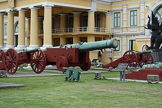
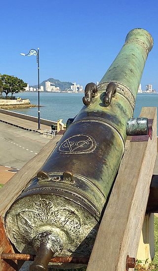
Phaya Tani is a 17th-century siege cannon from Pattani Province in southern Thailand. It is the largest cannon ever cast in what is now Thailand, measuring 2.7 m long and made of brass. It is on display in front of the Ministry of Defence, opposite the Grand Palace in Bangkok. The cannon still serves as the symbol of Pattani Province and it has been on the official seal of Pattani Province since 1939.
Raman is a district (amphoe) in the northeastern part of Yala province, southern Thailand.

Nong Chik is a district (amphoe) in Pattani province, southern Thailand.
Raja Biru or Ratu Biru ruled the Sultanate of Patani (1616–1624), succeeding her sister Raja Hijau. She was the second of three daughters of Sultan Mansur Shah who ruled the country. She was succeeded by her sister Raja Ungu. In Malay, her name means "Blue" or "Blue Queen."

Krue Se Mosque also called Gresik Mosque, Pitu Krue-ban Mosque, Pintu Gerbang Mosque, or Sultan Muzaffar Shah Mosque, is a mosque in Pattani Province, Thailand. Its construction may have begun in the 16th century. The surviving structure is described as having a mixture of Middle Eastern or European architectural styles.

The Sultan of Kelantan is the constitutional head of Kelantan state in Malaysia. The executive power of the state is vested in him as the monarch of the state. The current sultan, Muhammad V, is the 29th Sultan of Kelantan. He is the Head of Islam in the state and the source of all titles, honours and dignities of its people. He was the 15th Yang di-Pertuan Agong or the monarch and head of state of Malaysia from 13 December 2016 to his abdication on 6 January 2019, after his election on 14 October 2016 at the 243rd (special) Conference of Rulers.

Terengganu Malay is a Malayic language spoken in the Malaysian state of Terengganu all the way southward to coastal Pahang and northeast Johor. It is the native language of Terengganu Malays and highly localized Chinese Peranakan community as well as a second language among the smaller Indian minority.
The Seri Rambai is a seventeenth-century Dutch cannon displayed at Fort Cornwallis in George Town, the capital city of the Malaysian state of Penang and a UNESCO World Heritage Site. It is the largest bronze gun in Malaysia, a fertility symbol and the subject of legends and prophecy.
Lin Daoqian, also written as Lim Toh Khiam and Vintoquián, was a Chinese pirate of Teochew origin active in the 16th century. He led pirate attacks along the coast of Guangdong and Fujian, but they were driven away by the Ming navy forces in 1563. By 1567 he was again raiding the South China coast. He later moved to South East Asia, and settled in Patani where he established a significant presence. He died in Patani.

The Kingdom of Reman or Kingdom of Rahman was a landlocked semi-independent Malay kingdom in the northern Malay Peninsula.

Lim Ko Niao, Thai: ลิ้มกอเหนี่ยว), alternatively Lin Guniang or Lim Kor Niaw and also named Lim Kun Yew, is a deity worshipped by Chinese people in southern Thailand. She was said to be the sister of Lim Toh Khiam, and who according to legend committed suicide after she failed to persuade her brother to return home. She then began to be worshipped as a goddess by the ethnic Chinese communities in southern Thailand for her sense of filial piety and patriotic feeling for China. A shrine, the Leng Chu Kiang shrine, and a museum dedicated to her exist in Pattani.


