Pauatahanui

Last updated

Pauatahanui ( /ˈpətɑːhəˌni/ ; Māori:  [ˈpaʉatahanʉi] ) is a village in New Zealand's North Island. It is at the far eastern end of the Pauatahanui Inlet, an arm of the Porirua Harbour, northeast of Wellington. In local government terms, Pauatahanui is part of the Northern Ward of Porirua City.

North Island The northern of the two main islands of New Zealand

The North Island, also officially named Te Ika-a-Māui, is one of the two main islands of New Zealand, separated from the larger but much less populous South Island by Cook Strait. The island's area is 113,729 square kilometres (43,911 sq mi), making it the world's 14th-largest island. It has a population of 3,749,200.

Porirua Harbour bight in New Zealand

Te Awarua-o-Porirua Harbour, commonly known as Porirua Harbour, is a natural inlet in the south-western coast of the North Island of New Zealand. The city of Porirua, one of the four cities in the Wellington conurbation, surrounds it. The city centre is to the south of the harbour. The harbour has an entrance only a few hundred metres in width, close to the suburb of Plimmerton. It opens up into two arms, Porirua Inlet to the south and Pauatahanui Inlet to the north-east. Each arm is around three kilometres in length.

Wellington Capital city of New Zealand

Wellington is the capital city and second most populous urban area of New Zealand, with 418,500 residents. It is located at the south-western tip of the North Island, between Cook Strait and the Remutaka Range. Wellington is the major population centre of the southern North Island, and is the administrative centre of the Wellington Region, which also includes the Kapiti Coast and Wairarapa. Its latitude is 41°17′S, making it the world's southernmost capital of a sovereign state. Wellington features a temperate maritime climate, and is the world's windiest city by average wind speed.

Contents

At the 2001 New Zealand census, its population (including nearby wholly rural areas) was 831: 429 males and 402 females, a 23.1% increase in population since the previous census in 1996. At the 2006 census the population was 1,080 in 360 households. [1] At the 2013 census, 1080 people lived in the Pauatahanui area. [2]

History

Pauatahanui main street. PauatahanuiMainStreet.jpg
Pauatahanui main street.

Early settlement and history

After Te Rangihaeata was beaten in the 1846 Hutt Valley Campaign the area became safer as a route from the Hutt Valley via Belmont and Judgeford and on to the north, via Paekakariki to the Manawatu and Wanganui. [3] The road from Wellington reached Pauatahanui in September 1848, and a reliable road to the north as far as Paekakariki was completed by November 1849. Known nowadays as the "Paekakariki Hill Road", it continued to be the main road north until the road bridge was built at Paremata in 1939. Access from the Hutt Valley was also upgraded to a road in 1873, and the road that was to become State Highway 58 from Haywards was established in the 1870s.

Te Rangihaeata Māori chief

Te Rangihaeata, was a Ngāti Toa chief, nephew of Te Rauparaha. He had a leading part in the Wairau Affray and the Hutt Valley Campaign.

The Hutt Valley Campaign was a brief round of hostilities in the lower North Island of New Zealand between indigenous Māori and British settlers and military forces in 1846. The campaign was among the earliest of the 19th century New Zealand wars that were fought over issues of land and sovereignty. It was preceded by the Wairau affray and followed by the Wanganui campaign and was triggered by much the same pressures—the careless land purchasing practices of the New Zealand Company, armed government support for settler land claims, and complex intertribal tensions between local Māori. The three conflicts also shared many of the same combatants.

Belmont, a suburb of Lower Hutt, to the north of Wellington in the North Island of New Zealand, lies on the west bank of the Hutt River, on State Highway 2, the Wellington-Hutt main road, and across the river from the centre of Lower Hutt.

The first non-denominational Protestant chapel was built about 1856, and from 1861 Anglican services were held by a visiting clergyman once a fortnight. Congregations dwindled with an Anglican church built. It became tumbledown, and was demolished around 1910. [4] Other churches were St Joseph's Catholic Church (1878) and St Alban's Anglican Church (1898).

The first hotel was constructed in 1847 by former whalers Edward Boulton and Thomas Wilson. Burned down in 1859, it was replaced by a fourteen-room Boultons Hotel. From 1865 other hotels were the Horokiwi Hotel, the Pauatahanui Hotel, the Empire Hotel and the Junction Hotel, largely to serve the Cobb and Co stagecoach traffic. [5] In 1912 the area went "dry" and all the hotel bars closed. [6] In the 1911 electoral redistribution the area was transferred from the Otaki electorate to the new Wellington Suburbs and Country electorate, and no longer had William Field as a MP. The new electorate was "dry" as the precursor Wellington Suburbs electorate had already voted "dry" in the 1908 election. [7]

William Hughes Field New Zealand politician

William Hughes Field was a Member of Parliament in New Zealand; first for the Liberal Party, then Independent, and then for the Reform Party. He made a significant contribution to the development of tramping in the Tararua Range.

Wellington Suburbs was a parliamentary electorate in Wellington, New Zealand. It existed from 1893 to 1902, then from 1908 to 1911, and from 1919 to 1946. The electorate was represented by six Members of Parliament.

A community hall was built in 1904. It was demolished in 1966 and replaced. [8]

In World War II the US Marines had four camps in the Pauatahanui area; at Judgeford, at the Porirua side of the foot of the Haywards Hill, at Motukaraka, and in the Moonshine Valley. The Judgedford camp accommodated 3,755 men, the Moonshine camp had a recreation hall and a vehicle servicing depot, and the Haywards camp had a large theatre for the troops. Apart from a few huts for officers, most of the marines were in bell tents. [9]

Environmental preservation

Pauatahanui Inlet Pauatahanui Inlet-20070919.jpg
Pauatahanui Inlet

In the early 1970s the development of sections at Whitby on the south of the Pauatahanui Inlet caused noticeable silting and raised community concerns. This ultimately led to a detailed 3-year environmental study in 1975–1977, which was published as a book in 1980. Subsequently the Pauatahanui Wildlife Reserve was created, in 1984, in order to preserve the only large estuarine wetland left in the lower North Island. The wetland reserve is run by the Royal Forest and Bird Society with ongoing efforts to reduce human impact on the environment and to restore damaged areas. The reserve has several hides for viewing birdlife, boardwalks, and some barbecue / picnic areas for visitors.

Education

Pauatahanui School is notable as being one of the very few schools in New Zealand to be over 150 years old.[ citation needed ] It was established in 1855, originally in an undenominational chapel on the site of Rangihaeata's Pa, and later in the military barracks vacated by the troops. It is now increasing its pupil numbers because it serves the north-east corner of Whitby. As of August 2018, Pauatahanui School has a roll of 209 students from Years 1 to 8 (ages 5 to 12). [10] The nearest secondary schools to Pauatahanui are Aotea College in Aotea and Porirua College in Cannons Creek, both roughly 8.5 km away.

State Highway 58 skims the southern fringe of the village: to the east it leads to Judgeford, just up the valley, and over the hills to Lower Hutt in the Hutt Valley; and to the west it travels along the southern shore of the Pauatahanui Inlet skirting Whitby and through Golden Gate to meet New Zealand's most important road, State Highway 1, at Paremata at the mouth of the Inlet.

To the north, the shortest but generally not the fastest route to Paekakariki is the Paekakariki Hill Road mentioned above, serving the fertile Horokiri Valley. Branching off that road just beyond the urban limit is Grays Road, leading to Plimmerton.

Notable buildings

St Alban's Church St albans pauatahanui.jpg
St Alban's Church

Pauatahanui has a group of regionally significant 19th century buildings. They include St Alban's Church, St Joseph’s Roman Catholic Church, Thomas Hollis Stace Cottage, Barrys Place Historical Cottage and the Taylor-Stace Cottage. [11]

Built in 1847, Taylor-Stace Cottage is the Wellington region's oldest surviving house, and is currently used as a beauty salon. [12]

The former community hall (erected in 1967) was leased to a local company in 2003 and converted into the Lighthouse Cinema, the only cinema in Porirua's northeastern area. [13]

Related Research Articles

Whitby, New Zealand suburb of Porirua, New Zealand

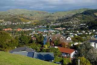
Whitby, a large suburb of Porirua City, New Zealand, located along much of the southern shore of the Pauatahanui Inlet of Porirua Harbour was comprehensively planned in the 1960s and it has been continuously developed since, with current landscaping and expansion in the hills behind the eastern part of Whitby to facilitate the future growth of the suburb.

Plimmerton human settlement

The suburb of Plimmerton lies in the northwest part of the city of Porirua in New Zealand, adjacent to some of the city's more congenial beaches. State Highway 1 and the North Island Main Trunk railway line pass just east of the main shopping and residential area.

Paremata

Paremata is a suburb of Porirua, on the Tasman Sea coast to the north of Wellington, New Zealand.

Haywards human settlement in New Zealand

Haywards is a small hillside suburb in the Hutt Valley near Wellington, New Zealand. It is notable for its large electrical substation, which is the main switching point for the Wellington region, and the home of the North Island converter station for the HVDC Inter-Island, which links the North and South Island electricity networks together.

Transmission Gully Motorway road in New Zealand

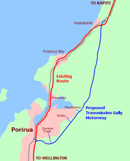
The Transmission Gully Motorway is a 27 km four-lane motorway under construction in Wellington, New Zealand. Construction officially began on 8 September 2014 and completion is scheduled for 2020.

Transmission Gully is a chain of steep-sided, isolated valleys in the Wellington Region of New Zealand. It runs approximately north-south between the Kapiti Coast and Tawa, through the hills behind the city of Porirua. A high voltage transmission line owned by Transpower, which gives the gully its name.

Mana, New Zealand

Mana is a suburb of Porirua City in New Zealand. It is a narrow isthmus bounded to the west by the entrance to Porirua Harbour, and to the east by the Pauatahanui inlet of the Porirua Harbour. Mana Island lies about three kilometres west of the isthmus.

Waitangirua is a suburb of Porirua City approximately 22km north of Wellington in New Zealand.

The Wellington and Manawatu Line is an unofficial name for the section of New Zealand's North Island Main Trunk Railway between Wellington and Palmerston North. Originally a government project, the line was constructed by the private Wellington and Manawatu Railway Company and bought by the government in December 1908.

Ken Gray (rugby union) rugby union player

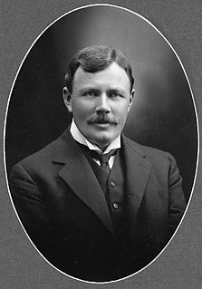
Kenneth Francis Gray, MBE, was an international rugby union player from Porirua, New Zealand. He represented New Zealand in 24 international games, playing lock and later prop forward. He could play on either side of a scrum. In 1970 he refused to tour South Africa in protest at its policy of apartheid and resigned from the game.

John Brian Burke is a former mayor of Porirua City, Wellington Region, New Zealand. Prior to his time as mayor from 1983 to 1998, he served 12 years as a city councillor with six years from 1977 to 1983 as deputy mayor. After a 15-year departure from the city council, in 2013 he stood for election as a city councillor in the eastern ward and was elected with a comfortable majority. He increased his majority at the 2016 local authority elections.

Wellington Suburbs and Country is a former parliamentary electorate in Wellington, New Zealand, from 1911 to 1919. The electorate was combined from Wellington Suburbs and Wellington Country electorates.

Paremata railway station on the Kapiti Line section of the North Island Main Trunk Railway (NIMT) in Paremata in the city of Porirua, New Zealand, is part of the Wellington Region's Tranz Metro suburban rail network.

The Haywards–Plimmerton Line was a railway development proposed several times between 1879 and the 1960s to connect the Hutt Valley and Porirua areas of Wellington via Haywards.

Judgeford is a suburb of Porirua, a city near Wellington, New Zealand. The only buildings are a dog boarding place called Kennels and Cattery, a golf course and houses. The closest school is Pauatahanui School. There is a nearby church called Saint Albans Church, but it is in Pauatahanui not Judgeford.

State Highway 58 is a New Zealand state highway in the Wellington Region linking the Hutt Valley to Porirua.

Moonshine Valley is a thinly populated valley with a population of around 201 in the Wellington Region of New Zealand, centered on the Moonshine Hill Road which leaves State Highway 58 near Judgeford and goes over the Tararua Range to the Riverstone Terraces suburbs and then joins River Road, Upper Hutt. The majority of Moonshine Valley is part of Upper Hutt, although the western part of the valley is part of Porirua.

References

  1. Rennie 2013, p. 222.
  2. "2013 Census Usually Resident Population Counts – Statistics New Zealand". Stats.govt.nz. Retrieved 2 December 2013.
  3. W. B. Healy, "Pauatahanui Inlet — an environmental study", New Zealand Department of Scientific and Industrial Research, 1980. ISSN 0077-9636
  4. Reilly 2013, p. 101.
  5. Reilly 2013, pp. 48-51.
  6. Mark Sheehan, Pauatahanui and the Inlet. The Porirua Museum, 1988
  7. Reilly 2013, p. 86-87.
  8. Us, Lighthouse Pauatahanui.
  9. Reilly 2013, pp. 148-152.
  10. "Directory of Schools - as at 13 September 2018". New Zealand Ministry of Education. Retrieved 22 September 2018.
  11. "Open evening at oldest cottage in Wellington". Wellington.scoop.co.nz. Retrieved 22 June 2012.
  12. "New look for oldest house". stuff.co.nz. Retrieved 20 June 2012.
  13. Reilly 2013, p. 210.

Coordinates: 41°06′S174°55′E / 41.100°S 174.917°E / -41.100; 174.917