Related Research Articles

A blizzard is a severe snowstorm characterized by strong sustained winds and low visibility, lasting for a prolonged period of time—typically at least three or four hours. A ground blizzard is a weather condition where snow is not falling but loose snow on the ground is lifted and blown by strong winds. Blizzards can have an immense size and usually stretch to hundreds or thousands of kilometres.

The National Hurricane Center (NHC) is the division of the United States' NOAA/National Weather Service responsible for tracking and predicting tropical weather systems between the Prime Meridian and the 140th meridian west poleward to the 30th parallel north in the northeast Pacific Ocean and the 31st parallel north in the northern Atlantic Ocean. The agency, which is co-located with the Miami branch of the National Weather Service, is situated on the campus of Florida International University in University Park, Miami, Florida.
The Northeast snowfall impact scale (NESIS) was created to measure snowstorms in the U.S. Northeast in much the same way the Saffir–Simpson hurricane scale records hurricane intensity and the enhanced Fujita scale with tornadoes. This scale takes into account the very high population of the Northeast, and thus snowfall amounts are often smaller compared to what other areas of the USA would consider significant snowfall amounts.

Minnesota has a humid continental climate, with hot summers and cold winters. Minnesota's location in the Upper Midwest allows it to experience some of the widest variety of weather in the United States, with each of the four seasons having its own distinct characteristics. The area near Lake Superior in the Minnesota Arrowhead region experiences weather unique from the rest of the state. The moderating effect of Lake Superior keeps the surrounding area relatively cooler in the summer and warmer in the winter, giving that region a smaller yearly temperature variation. On the Köppen climate classification, much of the southern third of Minnesota—roughly from the Twin Cities region southward—falls in the hot summer zone (Dfa), and the northern two-thirds of Minnesota falls in the warm summer zone (Dfb).

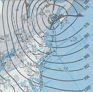
The Great Appalachian Storm of November 1950 was a large extratropical cyclone which moved through the Eastern United States, causing blizzard conditions along the western slopes of the Appalachian Mountains and significant winds and heavy rainfall east of the mountains. Hurricane-force winds, peaking at 110 miles per hour (180 km/h) in Concord, New Hampshire, and 160 mph (260 km/h) in the highlands of New England, disrupted power to 1 million customers during the event.
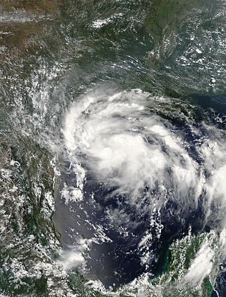
Tropical Storm Erin was a minimal tropical storm that made landfall in Texas in August 2007. The storm's remnants also unexpectedly restrengthened over Oklahoma, causing damage there as well. The second tropical cyclone to make landfall in the United States in the 2007 Atlantic hurricane season and the fifth named storm of the year, Erin formed in the Gulf of Mexico on August 14 from a persistent area of convection. It attained tropical storm status the next day, and on August 16, 2007, Erin made landfall near Lamar, Texas, and persisted over land across Texas before moving northward into Oklahoma. Due to the brown ocean effect, Erin intensified after landfall. The storm resulted in sixteen fatalities and worsened an already-severe flooding issue in Texas.

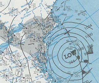
The December 2000 nor'easter was a significant winter storm that impacted the Mid-Atlantic and New England regions of the United States around the end of the month. It began as an Alberta clipper that moved southeastward through the central United States and weakened over the Ohio Valley. However, it redeveloped off the coast of North Carolina and moved northward as it intensified. It moved into central Long Island and eventually tracked northward into New England. The storm dropped heavy precipitation throughout the Northeast, especially in northern New Jersey and eastern New York, where snowfall often exceeded 2 ft (0.61 m). Even so, as it struck on a weekend, its effects were generally minor and mostly limited to travel delays, traffic accidents, and business closures.
The February 1995 nor'easter was a significant nor'easter that impacted the Mid-Atlantic and New England regions of the United States around the beginning of the month. It was the only major nor'easter of the 1994–1995 winter.
The February 1987 nor'easter was a significant winter storm in the US that impacted the Mid-Atlantic States around the end of the month. It delivered 8–12 hours of heavy, wet snowfall to several states from West Virginia to New York between February 22 and February 24. The storm was both preceded and followed by relatively warm temperatures, causing the snow to rapidly melt. The mild conditions were the result of a moderate anticyclone over the region that deteriorated as the nor'easter approached. Cold air damming likely took place prior to the storm's formation.

The March 18–20, 1956 nor'easter was a significant winter storm in the United States that affected the Mid-Atlantic States and southern New England. The storm ranked as Category 1, or "notable", on the Northeast Snowfall Impact Scale. A high-pressure area north of New York State, developing in the wake of another system on March 15–16, provided cold air for the snowfall. It was among a series of snowstorms to affect the region during the month.

The March 18–22, 1958 nor'easter was an unusual late-season and violent winter storm that impacted the Mid-Atlantic and New England regions of the United States. Its snowfall extended from North Carolina through Maine.

The February 1952 nor'easter was a significant winter storm that impacted the New England region of the United States. The storm ranked as Category 1, or "notable", on the Northeast Snowfall Impact Scale. Its rapid intensification resulted in heavy snowfall between February 17 and 18, accumulating to 12 to 30 inches. High winds also affected central and northern New England. The nor'easter is estimated to have caused 42 fatalities. In Maine, over 1,000 travelers became stranded on roadways. Two ships cracked in two offshore New England during the storm.

The January 1961 nor'easter was a significant winter storm that impacted the Mid-Atlantic and New England regions of the United States. It was the second of three major snowstorms during the 1960–1961 winter. The storm ranked as Category 3, or "major", on the Northeast Snowfall Impact Scale.

The December 1960 nor'easter was a significant early-season winter storm that impacted the Mid-Atlantic and New England regions of the United States. Moderate to heavy snowfall fell from West Virginia to eastern Maine, amounting to 10 in (25 cm) or more in parts of 13 states and peaking at 21.4 in (54 cm) at Newark, New Jersey. The storm was accompanied by strong winds, gusting to over 90 mph (140 km/h) in coastal New England, and left in its wake a dangerously cold air mass. The storm originated in a weak low pressure area which formed over the western Gulf of Mexico on December 10. A secondary low developed over South Carolina on the next day, supported by the merger of two troughs aloft. Sliding southeast of New England, the new storm explosively deepened to become a full-fledged nor'easter, with a minimum central air pressure of 966 mbar. It began to weaken over the Canadian Maritimes.

The March 1960 nor'easter was a severe winter storm that impacted the Mid-Atlantic and New England regions of the United States. The storm ranked as Category 4, or "crippling", on the Northeast Snowfall Impact Scale. Northeasterly flow, combined with the storm's slower forward motion, enhanced snowfall across the region. The cyclone began moving away from the United States on March 5. It took place during a stormy period in the affected region, contributing to record snowfall.

The December 1969 nor'easter was a strong winter storm that mainly affected the Northeastern United States and southern Quebec between December 25 and December 28, 1969. The multi-faceted storm system included a tornado outbreak, record snow accumulations, a damaging ice storm, and flooding rains.

Timothy Michael Samaras was an American engineer and storm chaser best known for his field research on tornadoes and time on the Discovery Channel show Storm Chasers. He died in the 2013 El Reno tornado.

Louis Uccellini is a meteorologist and former director of the US National Weather Service (NWS) from 2013 to 2022. He was also director of the National Centers for Environmental Prediction and served as the Permanent Representative of the United States for the World Meteorological Organization.
References
- ↑ Loeb, Harriet (February 2, 2009). "Paul Kocin: A Person for One Season". National Oceanic and Atmospheric Administration. Archived from the original on 11 November 2010. Retrieved 3 August 2024.
- ↑ Patrick O'Driscoll (January 31, 2006). "Storm ranking system starts; Snow categories similar to those for hurricanes". USA Today. Archived from the original on December 3, 2012. Retrieved February 6, 2010.
| | This biographical article about a climatologist or meteorologist is a stub. You can help Wikipedia by expanding it. |