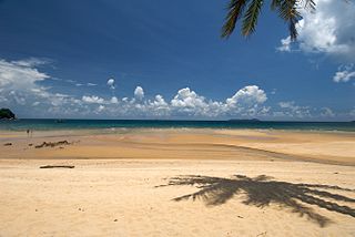
Tioman Island is 32 kilometres off the east coast of Rompin District, Pahang, Malaysia. It is 39 kilometres long and 12 kilometres wide and has seven villages, the largest and most populous being Kampung Tekek on the central western coast. The densely forested island is sparsely inhabited, and is surrounded by numerous coral reefs, making it a popular scuba diving, snorkelling, and surfing spot. There are many resorts and chalets for tourists around the island, which has duty-free status.

Langkawi, officially known as Langkawi, the Jewel of Kedah, is a duty-free island and an archipelago of 99 islands located some 30 km off the coast of northwestern Malaysia and a few kilometres south of Ko Tarutao, adjacent to the Thai border. Politically, it is an administrative district of Kedah, with Kuah as its largest town. Pantai Cenang is the island's most popular beach and tourist area.

The Perhentian Islands are islands in Besut District, Terengganu, Malaysia.

Sisters' Islands are two of the Southern Islands in Singapore and are located to the south of the main island of Singapore, off the Straits of Singapore. It can be reached via a boat ride from Marina South Pier or West Coast Pier.
Pulau Hantu is located to the south of the main island of Singapore, off the Straits of Singapore. Pulau Hantu is actually made up of two islets: Pulau Hantu Besar and Pulau Hantu Kechil, with a total area of 12.6 hectares. At low tide, it is possible to wade across the shallow lagoon between the two islands, but not at high tide.

Redang Island is an island in Kuala Nerus District, Terengganu, Malaysia. It is one of the largest islands off the east coast of Peninsular Malaysia and one of the most beautiful islands in the world. It is famous for its crystal clear waters and white sandy beaches. It is one of nine islands, which form a marine sanctuary park offering snorkeling and diving opportunities for tourists.

Sibu Island is an island group in Mersing District, Johor, Malaysia.

Apo Island is a volcanic island covering 74 hectares in land area, 7 kilometers off the southeastern tip of Negros Island and 30 kilometers south of the Negros Oriental capital of Dumaguete in the Philippines. The name "Apo" means "elder" or "respected ancestor" in the Visayan languages.
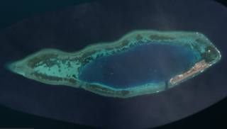
Swallow Reef, also known as Malay: Pulau Layang-Layang; Vietnamese: Đá Hoa Lau; Mandarin Chinese: 燕子島; pinyin: Yànzi Dǎo; Celerio Reef, is an oceanic atoll of the Spratly Islands administered by Malaysia.
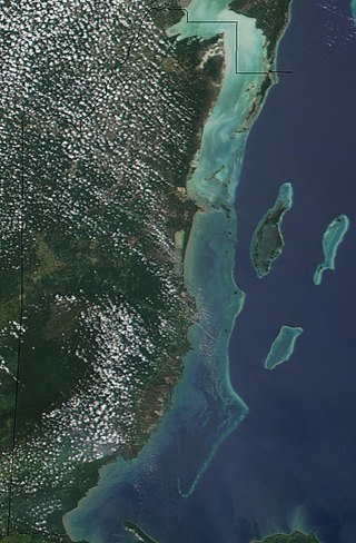
The Belize Barrier Reef is a series of coral reefs straddling the coast of Belize, roughly 300 metres (980 ft) offshore in the north and 40 kilometres (25 mi) in the south within the country limits. The Belize Barrier Reef is a 300-kilometre (190 mi) long section of the 900-kilometre (560 mi) Mesoamerican Barrier Reef System, which is continuous from Cancún on the north-eastern tip of the Yucatán Peninsula through the Riviera Maya and down to Honduras, making it the second largest coral reef system in the world after the Great Barrier Reef in Australia. It is Belize's top tourist destination, popular for scuba diving and snorkeling and attracting almost half of its 260,000 visitors. It is also vital to the country's fishing industry.

Hol Chan Marine Reserve is a marine reserve close to Ambergris Caye and Caye Caulker, off the coast of Belize. It covers approximately 18 km² (4,448 acres) of coral reefs, seagrass beds, and mangrove forest. Hol Chan is Mayan for "little channel".

Apo Reef is a coral reef system in the Philippines situated in the western waters of Occidental Mindoro province in the Mindoro Strait. Encompassing 34 km2 (13 sq mi), it is considered the world's second-largest contiguous coral reef system, and is the largest in the country. The reef and its surrounding waters are protected areas administered as the Apo Reef Natural Park (ARNP). It is one of the best known and most popular diving regions in the country, and is on the tentative list for UNESCO World Heritage Sites.

Ko Lipe is a small island in the Adang-Rawi Archipelago of the Strait of Malacca, in Satun Province of southwest Thailand, close to the Malaysian border. Its Thai name, the corrupted form of the original Malay name, Pulau Nipis is transliterated in many different ways into English. The most common names are "Koh Lipe", "Koh Lipeh", "Ko Lipey", and "Ko Lipe".

The Maldives, officially the Republic of Maldives, is a small archipelagic state in South Asia. It lies in the Indian Ocean southwest of Sri Lanka and India, about 700 kilometres (430 mi) from the Asian continent's mainland. The chain of 26 atolls stretches across the Equator from Ihavandhippolhu Atoll in the north to Addu Atoll in the south. The land area is roughly 298 square kilometres. Malé is the capital.

North Halmahera Regency is a regency of North Maluku Province, Indonesia. It was declared a separate Regency on 25 February 2003, formed from part of the former North Maluku Regency. The capital town of the regency lies at the port of Tobelo. The Regency, which was considerably reduced by the separation of Morotai Island to form a separate regency on 26 November 2008, now covers an area of 3,404.27 square kilometres (1,314.40 sq mi) and had a population of 161,847 people at the 2010 Census, 179,783 at the 2015 Intermediate Census. and 197,640 at the 2020 Census. The official estimate as at mid 2023 was 203,213. The principal settlements are Tobelo, Kao and Galela. The area is noted for its white beaches and coral reefs.

Molokini is a crescent-shaped, partially submerged volcanic crater which forms a small, uninhabited islet located in ʻAlalākeiki Channel between the islands of Maui and Kahoʻolawe, within Maui County in Hawaiʻi. It is the remains of one of the seven Pleistocene epoch volcanoes that formed the prehistoric Maui Nui island, during the Quaternary Period of the Cenozoic Era.

Pom Pom Island is a small coral reef island in the Celebes Sea approximately 30 kilometres north east of Semporna town, Sabah, East Malaysia.

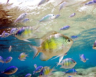
Tourism is one of the major industries in the Great Barrier Reef region. Approximately 2.19 million people visit the Great Barrier Reef each year. According to the WWF, tourism of the area contributes $5.89 billion a year to the Australian economy, and employs approximately 69,000 people. Ove Hoegh-Guldberg sees the key competitive advantage of the Great Barrier Reef as opposed to other, closer, reef tourism destinations is the region's reputation as being "the most pristine coral reef on the planet". The GBRMPA states that careful management, which includes permits for camping and all commercial marine tourism within the Great Barrier Reef Marine Park, seeks to ensure that tourists have minimal impact on the reef. However, rising incidences of widespread coral bleaching, coastal development, and tourism impacts have taken a toll the biodiversity of the reef.
Piti Bomb Holes Marine Preserve is a marine protected area comprising all of Piti Bay on the western coast of Guam, located off of the village of Piti in the Philippine Sea. The defining "bomb hole" features, named because they look like bomb craters in the reef flat, are actually natural percolation pits where fresh water filters into the shallow lagoon at a depth of 25 to 30 feet. The largest pit houses the commercial Fish Eye Marine Park tourist attraction, which includes a wooden pier to a underwater observatory and a Seawalker tour of the lagoon bottom. It is visited by more than 200,000 people annually. The Piti preserve is the most ecologically diverse of Guam's five marine preserves. The pit around Fish Eye is a popular snorkeling and recreational diving site.

