Peninver

Last updated

Peninver
Houses above Peninver.jpg
Houses above Peninver
Argyll and Bute UK location map.svg
Red pog.svg
Peninver
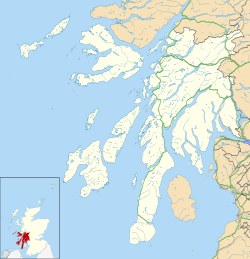
Location within Argyll and Bute
OS grid reference NR759249
Council area
Lieutenancy area
  • Argyll and Bute
Country Scotland
Sovereign state United Kingdom
Post town CAMPBELTOWN
Postcode district PA28
Police Scotland
Fire Scottish
Ambulance Scottish
UK Parliament
Scottish Parliament
List of places
UK
Scotland
55°28′01″N5°32′53″W / 55.467°N 5.548°W / 55.467; -5.548

Peninver (pronounced "Pe-NEE-ver") is a small village situated on the east coast of Kintyre, Scotland. It lies 4.5 miles (7 kilometres) north of Campbeltown, the principal town in the area. The village is located on Ardnacross Bay, with an outlook over the bay to the Isle of Arran.
Related Research Articles

<span class="mw-page-title-main">Inverclyde</span> Council area of Scotland

Inverclyde is one of 32 council areas used for local government in Scotland. Together with the East Renfrewshire and Renfrewshire council areas, Inverclyde forms part of the historic county of Renfrewshire, which currently exists as a registration county and lieutenancy area. Inverclyde is located in the west central Lowlands. It borders the North Ayrshire and Renfrewshire council areas, and is otherwise surrounded by the Firth of Clyde.

<span class="mw-page-title-main">Firth of Clyde</span> Inlet on the west coast of Scotland

The Firth of Clyde is the estuary of the River Clyde, on the west coast of Scotland. The Firth has some of the deepest coastal waters of the British Isles. The Firth is sheltered from the Atlantic Ocean by the Kintyre peninsula. The Firth lies between Argyll and Bute in the west and Inverclyde, North Ayrshire and South Ayrshire in the east. The Kilbrannan Sound is a large arm of the Firth, separating the Kintyre Peninsula from the Isle of Arran. The Kyles of Bute separates the Isle of Bute from the Cowal peninsula.

<span class="mw-page-title-main">Dalgety Bay</span> Human settlement in Scotland

Dalgety Bay is a coastal town and parish in Fife, Scotland, on the north shore of the Firth of Forth, 9 miles from Edinburgh city centre. The civil parish is the 8th largest in Fife with a population of 10,777 (2011)

<span class="mw-page-title-main">Brodick</span> Village in Scotland

Brodick is the main village on the Isle of Arran, in the Firth of Clyde, Scotland. It is halfway along the east coast of the island, in Brodick Bay below Goat Fell, the tallest mountain on Arran. The name is derived from the Norse "breda-vick" meaning "Broad Bay".

<span class="mw-page-title-main">Whiting Bay</span> Village in Scotland

Whiting Bay is a village located on the Isle of Arran in the Firth of Clyde, Scotland four miles south of Lamlash and eight miles south of Brodick. With more than 600 inhabitants it’s the third largest village on the island of Arran, behind Lamlash and Brodick.

<span class="mw-page-title-main">Kintyre</span> Peninsula in Argyll and Bute, Scotland, UK

Kintyre is a peninsula in western Scotland, in the southwest of Argyll and Bute. The peninsula stretches about 30 miles, from the Mull of Kintyre in the south to East and West Loch Tarbert in the north. The region immediately north of Kintyre is known as Knapdale.

<span class="mw-page-title-main">Stronsay</span>

Stronsay is an island in Orkney, Scotland. It is known as Orkney's 'Island of Bays', owing to an irregular shape with miles of coastline, with three large bays separated by two isthmuses: St Catherine's Bay to the west, the Bay of Holland to the south and Mill Bay to the east. Stronsay is 3,275 hectares in area, and 44 metres in altitude at its highest point. It has a usually resident population of 349. The main village is Whitehall, home to a heritage centre.

<span class="mw-page-title-main">Wemyss Bay</span> Human settlement in Scotland

Wemyss Bay is a village on the coast of the Firth of Clyde in Inverclyde in the west central Lowlands of Scotland. It is in the traditional county of Renfrewshire. It is adjacent to Skelmorlie, North Ayrshire. The town and villages have always been in separate counties, divided by the Kelly Burn.

<span class="mw-page-title-main">Cruden Bay</span> Human settlement in Scotland

Cruden Bay is a small village in Scotland, on the north coast of the Bay of Cruden in Aberdeenshire, 26 miles (42 km) north of Aberdeen.

<span class="mw-page-title-main">Findhorn</span> Human settlement in Scotland

Findhorn is a village in Moray, Scotland. It is located on the eastern shore of Findhorn Bay and immediately south of the Moray Firth. Findhorn is 3 miles (5 km) northwest of Kinloss, and about 5 miles (9 km) by road from Forres.

<span class="mw-page-title-main">St Margaret's Hope</span> Human settlement in Scotland

St Margaret's Hope is a village in the Orkney Islands, off the north coast of Scotland. It is known locally as The Hope or The Hup. With a population of about 550, it is Orkney's third largest settlement after Kirkwall and Stromness.

<span class="mw-page-title-main">Craignure</span> Ferry port on Isle of Mull, Scotland

Craignure is a village and the main ferry port on the Isle of Mull, Argyll and Bute, Scotland. The village is within the parish of Torosay.

<span class="mw-page-title-main">Uig, Snizort</span> Human settlement in Scotland

Uig is a village at the head of Uig Bay on the west coast of the Trotternish peninsula on the Isle of Skye, Scotland. In 2011 it had a population of 423.

<span class="mw-page-title-main">Wemyss Bay railway station</span> Railway station in Inverclyde, Scotland

Wemyss Bay railway station serves the village of Wemyss Bay, Inverclyde, Scotland. The station is a terminus on the Inverclyde Line, about 26 miles (42 km) west of Glasgow Central. The station incorporates the Caledonian MacBrayne ferry terminal connecting mainland Scotland to Rothesay on the Isle of Bute. The station is managed by ScotRail.

<span class="mw-page-title-main">Tarskavaig</span> Human settlement in Scotland

Tarskavaig is a crofting village on the west coast of Sleat on the Isle of Skye in Scotland. It sits in a glen which meets Tarskavaig Bay and lies opposite the Isles of Eigg, Rum and Canna. It is often said that Tarskavaig has the best view of the Cuillin in Skye.

<span class="mw-page-title-main">Shulishader</span> Human settlement in Scotland

Shulishader is a small village with a population of around 120 people in Point, Outer Hebrides on the Isle of Lewis, Scotland. Located on the north-western side of the Eye Peninsula, it overlooks Broad Bay. Most of the village is over 60m above sea level, affording excellent views across the bay and northern Lewis, though the land falls gently towards the sea before ending in small cliffs. There are several small, difficult to access, sandy beaches, and a small cove on the coastline. The cove is accessible via 88 dilapidated steps, and contains a pebble peach, some natural caves and a concrete structure once used for boat moorings above the high tide line.

<span class="mw-page-title-main">Elgol</span> Human settlement in Scotland

Elgol is a village on the shores of Loch Scavaig towards the end of the Strathaird peninsula in the Isle of Skye, in the Scottish Highlands.

<span class="mw-page-title-main">Harrapool</span> Human settlement in Scotland

Harrapool is a village, that lies on the right hand side of Broadford Bay, in Isle of Skye, Scottish Highlands and is in the Scottish council area of Highland.

Culbin Sands, Forest and Findhorn Bay is a huge area of coast and countryside and an SSSI in Moray, Scotland, stretching from just east of the town of Nairn eastwards to the village of Findhorn and its bay. All of the areas are very important for wildlife in general and are strongly protected by law. The Culbin Sands are known in Gaelic as Bar Inbhir Èireann.