Oconto County is a county in the U.S. state of Wisconsin. As of the 2020 census, the population was 38,965. Its county seat is Oconto. The county was established in 1851.
Kewaunee County is a county located in the U.S. state of Wisconsin. As of the 2020 census, the population was 20,563. Its county seat is Kewaunee. The county was created in 1852 and organized in 1859. Its Menominee name is Kewāneh, an archaic name for a species of duck. Kewaunee County is part of the Green Bay, WI Metropolitan Statistical Area as well as the Green Bay-Shawano, WI Combined Statistical Area.
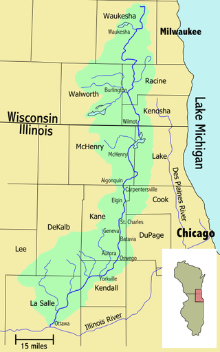
The Fox River is a 202-mile-long (325 km) tributary of the Illinois River, flowing from southeastern Wisconsin to Ottawa, Illinois in the United States. The Wisconsin section was known as the Pishtaka River in the 19th century. There is another Fox River in Wisconsin that flows through Lake Winnebago into Green Bay. There are also two other "Fox Rivers" in southern Illinois: the Fox River and a smaller "Fox River" that joins the Wabash River near New Harmony, Indiana.

Lake Winnebago is a shallow freshwater lake in the north central United States, located in east central Wisconsin. At 137,700 acres, it is the largest lake entirely within the state, covering an area of about 30 miles by 10 miles with 88 miles of shoreline, an average depth of 15.5 feet, and a maximum depth of 21 feet. It has many shallow reefs along the west shore and a drop-off type shoreline on the east. There are several islands along the west shore.

The Kankakee River is a tributary of the Illinois River, approximately 133 miles (214 km) long, in the Central Corn Belt Plains of northwestern Indiana and northeastern Illinois in the United States. At one time, the river drained one of the largest wetlands in North America and furnished a significant portage between the Great Lakes and the Mississippi River. Significantly altered from its original channel, it flows through a primarily rural farming region of reclaimed cropland, south of Lake Michigan.

The Wolf River is a 225 mi (362 km) long tributary of the Fox River in northeastern Wisconsin in the Great Lakes region of the United States. The river is one of the two National Scenic Rivers in Wisconsin, along with the St. Croix River. The scenic portion is 24 miles (39 km) long. The river and its parent the Fox River and associated lakes are known for their sturgeon which spawn every spring upstream on the lower river until blocked by the Shawano Dam. The river flows through mostly undeveloped forestland southerly from central Forest County in the north to Lake Poygan in the south. The lake is part of the Winnebago Pool of lakes fed by both the Fox and Wolf Rivers. The Fox-Wolf basin is usually considered to be a single unified basin and the rivers themselves may be referred to as the Fox-Wolf River system.

The Driftless Area, also known as Bluff Country and the Paleozoic Plateau, is a topographical and cultural region in the Midwestern United States that comprises southwestern Wisconsin, southeastern Minnesota, northeastern Iowa, and the extreme northwestern corner of Illinois. The Driftless Area is a USDA Level III Ecoregion: Ecoregion 52. The Driftless Area takes up a large portion of the Upper Midwest forest–savanna transition. The Blufflands refers to the eastern section of the Driftless area in Minnesota, due to the steep bluffs and cliffs around the river valleys. The western half is known as the Rochester Plateau, which is flatter than the Blufflands. The Coulee Region refers to the southwestern part of the Driftless Area in Wisconsin. It is named for its numerous ravines.

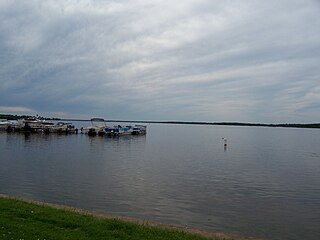
Located in northeastern Wisconsin, the Oconto River is a tributary of Lake Michigan via Green Bay. The Oconto River is 56.9 miles (91.6 km) long, stretching from the confluence of its North and South branches at Suring, Wisconsin, to Green Bay at the city of Oconto. Its drainage basin covers 2,416 square miles (6,260 km2), encompassing most of Oconto County as well as portions of Shawano, Marinette, Menominee, Langlade, and Forest counties.

Paynes Prairie Preserve State Park is a Florida State Park, encompassing a 21,000-acre (85 km2) savanna in Alachua County, Florida lying between Micanopy and Gainesville. It is also a U.S. National Natural Landmark. It is crossed by both I-75 and U.S. 441. It is in the center of the Paynes Prairie Basin. The basin's primary source of drainage is Alachua Sink. During occasional wet periods, the basin will become full. A notable period occurred from 1871 to 1891 when the Alachua Sink was temporarily blocked. During this period, shallow draft steamboats were a frequent sight on Alachua Lake in the center of the prairie. The region was also historically known as the Alachua Savannah. Its drainage has been modified by several canals. Since 1927, Camps Canal has linked the basin to the River Styx which leads to Orange Lake and eventually the Atlantic Ocean through the St. Johns River. That reduced the basins water intake by half. Additional changes to the prairie's environment have been detrimental to its hydrology. In 1970, the state of Florida acquired the land and has been in the process of restoring the environment to a more natural condition ever since.

The Door Peninsula is a peninsula in eastern Wisconsin, separating the southern part of the Green Bay from Lake Michigan. The peninsula includes northern Kewaunee County, northeastern Brown County, and the mainland portion of Door County. It is on the western side of the Niagara Escarpment. Well known for its cherry and apple orchards, the Door Peninsula is a popular tourism destination. With the 1881 completion of the Sturgeon Bay Ship Canal, the northern half of the peninsula became an island.

The Kinnickinnic River is one of three primary rivers that flows into the harbor of Milwaukee, Wisconsin, at Lake Michigan, along with the Menomonee River and Milwaukee River. It is locally called the "KK River".
Green Lake — also known as Big Green Lake — is a lake in Green Lake County, Wisconsin, United States. Green Lake has a maximum depth of 237 ft (72 m), making it the deepest natural inland lake in Wisconsin and the second largest by volume. The lake covers 29.72 km2 and has an average depth of 30.48 m (100.0 ft). Green Lake has 43.94 km (27.30 mi) of diverse shoreline, ranging from sandstone bluffs to marshes.

The Klamath Basin is the region in the U.S. states of Oregon and California drained by the Klamath River. It contains most of Klamath County and parts of Lake and Jackson counties in Oregon, and parts of Del Norte, Humboldt, Modoc, Siskiyou, and Trinity counties in California. The 15,751-square-mile (40,790 km2) drainage basin is 35% in Oregon and 65% in California. In Oregon, the watershed typically lies east of the Cascade Range, while California contains most of the river's segment that passes through the mountains. In the Oregon-far northern California segment of the river, the watershed is semi-desert at lower elevations and dry alpine in the upper elevations. In the western part of the basin, in California, however, the climate is more of temperate rainforest, and the Trinity River watershed consists of a more typical alpine climate.

Wisconsin, a state in the Midwestern United States, has a vast and diverse geography famous for its landforms created by glaciers during the Wisconsin glaciation 17,000 years ago. The state can be generally divided into five geographic regions—Lake Superior Lowland, Northern Highland, Central Plain, Eastern Ridges & Lowlands, and Western Upland. The southwestern part of the state, which was not covered by glaciers during the most recent ice age, is known as the Driftless Area. The Wisconsin glaciation formed the Wisconsin Dells, Devil's Lake, and the Baraboo Range. A number of areas are protected in the state, including Devil's Lake State Park, the Apostle Islands National Lakeshore, and the Chequamegon–Nicolet National Forest.
Shawano Lake is a lake situated in Shawano County in northeastern Wisconsin. Shawano Lake is a hard water drainage lake with multiple inlets and one major outlet, the Wolf River. A dam on the Wolf River located in the City of Shawano raises the water levels of Shawano Lake. Shawano Lake is approximately 6,178 acres (25.00 km2), with an average depth of approximately 9 feet (2.7 m) and a maximum depth of approximately 42 feet (13 m). The shoreline length is estimated at 18 miles (29 km). The Towns of Wescott, and Washington, and the Village of Cecil border Shawano Lake.

The Wiouwash State Trail is a rail trail in northeastern Wisconsin. Its name is derived from the first two letters of the four counties it traverses: Winnebago, Outagamie, Waupaca, and Shawano. The trail's Tribal Heritage Crossing of Lake Butte des Morts is a nationally designated recreation trail. The trail is used by walkers, hikers, bikers, horseback riders, and snowmobilers during the winter months. Two sections of the trail are complete: 24 miles from Aniwa south to Split Rock and 21 miles from Hortonville south to Oshkosh.
The Devils River is a small 15.8-mile-long (25.4 km) river in the state of Wisconsin in the United States. The Devils River flows primarily through Brown and Manitowoc counties and joins with the Neshota River to form the West Twin River. It is part of the 176-square-mile (460 km2) West Twin River watershed.
The West Branch Lackawanna River is a tributary of the Lackawanna River in Susquehanna County, Pennsylvania, in the United States. It is approximately 9.5 miles (15.3 km) long and flows through Ararat Township, Herrick Township, and Union Dale. The watershed of the river has an area of 16.8 square miles (44 km2). The river is not designated as an impaired stream and it has a high level of water quality. Lakes and wetlands in the river's watershed include Ball Lake, Fiddle Lake, Hathaway Lake, Lake Romobe, Lewis Lake, Lowe Lake, and Sink Hole Swamp. The river is also dammed by at least two dams: the Romobe Lake Dam and the Hathaway Pond Dam.

Lake Namakagon is located in Bayfield County, Wisconsin. The lake is a large freshwater drainage lake that opens inlet and outlet of streams located between Lake Superior and Mississippi River system. The lake is located in the upper Namekagon river watershed as St. Croix river basin is the subwatershed of it. The lake derives its name from the Ojibwe language, and it means "Lake abundant with sturgeons." It is known for tourism and was the home of the legendary Anishinaabe Chief Namakagon.