Penton Mewsey | |
---|---|
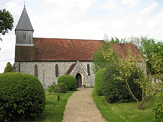
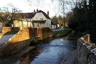
Penton Mewsey – Holy Trinity Church | |
Penton Mewsey shown within Hampshire | |
Population | 412 (census 2011) [1] |
OS grid reference | SU329474 |
Civil parish |
|
District | |
Shire county | |
Region | |
Country | England |
Sovereign state | United Kingdom |
Post town | ANDOVER |
Postcode district | SP11 |
Dialling code | 01264 |
Police | Hampshire |
Fire | Hampshire |
Ambulance | South Central |
EU Parliament | South East England |
UK Parliament | |
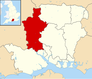
Penton Mewsey is a village and civil parish in Hampshire, England. It is located 2 miles (3.2 km) north-west of Andover.
In England, a civil parish is a type of administrative parish used for local government, they are a territorial designation which is the lowest tier of local government below districts and counties, or their combined form, the unitary authority. Civil parishes can trace their origin to the ancient system of ecclesiastical parishes which historically played a role in both civil and ecclesiastical administration; civil and religious parishes were formally split into two types in the 19th century and are now entirely separate. The unit was devised and rolled out across England in the 1860s.
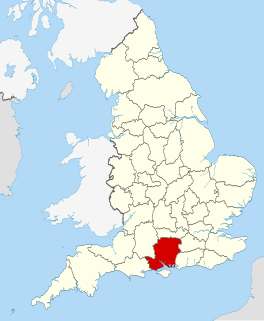
Hampshire is a county on the southern coast of England. The county town is the city of Winchester. Its two largest cities, Southampton and Portsmouth, are administered separately as unitary authorities; the rest of the county is governed by Hampshire County Council.
Andover is a town in the English county of Hampshire. The town is on the River Anton, a major source of the Test, 18 miles (29 km) west of the town of Basingstoke, both major rail stops. It is 15 miles (24 km) NNW of the city of Winchester, 25 miles (40 km) north of the city of Southampton and 65 miles (105 km) WSW of London. Andover is twinned with the towns of Redon in France, Goch in Germany, and Andover, Massachusetts in the United States.
The village is home to approximately 400 people and has about 110 houses. The name Penton is derived from Penitone, which is a farm held at penny rent. The village is adjacent to the hamlet and parish of Penton Grafton. Both villages are collectively known as The Pentons.
A penny is a coin or a unit of currency in various countries. Borrowed from the Carolingian denarius, it is usually the smallest denomination within a currency system. Presently, it is the formal name of the British penny (abbr. p) and the informal name of one American cent (abbr. ¢) as well as the informal Irish designation of 1 cent euro coin (abbr. c). It is the informal name of the cent unit of account in Canada, although one cent coins are no longer minted there. The name is also used in reference to various historical currencies also derived from the Carolingian system, such as the French denier and the German pfennig. It may also be informally used to refer to any similar smallest-denomination coin, such as the euro cent or Chinese fen.
Penton Grafton is a village and civil parish in the Test Valley district of Hampshire, England. It is adjacent to the village and parish of Penton Mewsey. Both villages are collectively known as The Pentons.
Until the 1920s the Pentons were mainly agricultural communities supporting sheep and corn, typical of northern Hampshire at the time. The Pentons are still surrounded by farmland which is currently completely arable. Today, three stables provide the main village-based commercial activities. The Holy Trinity church dates from the 14th century, although it was refurbished extensively in the 19th century.
Arable land is, according to one definition, land capable of being ploughed and used to grow crops. In Britain, it was traditionally contrasted with pasturable land such as heaths which could be used for sheep-rearing but not farmland.
It is also the current home of Sir George Young.
Test Valley is a local government district and borough in Hampshire, England, named after the valley of the River Test. Its council is based in Andover.
Pimperne is a village and civil parish in north Dorset, England, situated on Cranborne Chase 2 miles (3.2 km) northeast of the town of Blandford Forum. In the 2011 census the civil parish had 478 households and a population of 1109.
Exton is a small village and civil parish in the City of Winchester district of Hampshire, England. The village lies in the South Downs National Park, on the west bank of the River Meon, immediately to the north of Corhampton. It is located two miles north east of Droxford and five miles north east of Bishops Waltham. Its name first appears in 940 as East Seaxnatune, meaning "farmstead of the East Saxons".
Horndean is a village and civil parish in the East Hampshire district of Hampshire, England. It is 8 miles (13 km) north of Portsmouth.
Beech Hill is a village and civil parish in Berkshire, England. It is in the south east of the West Berkshire district and bounds Hampshire and Wokingham district. The Foudry Brook, a tributary of the Kennet, and the Reading to Basingstoke Line, run through the north of the parish.
Dummer is a parish and village in Hampshire, England. It is 6 miles south-west of Basingstoke and half a mile south of Junction 7 on the M3 motorway.
Ashmansworth is a village and civil parish in the Basingstoke and Deane district of the English county of Hampshire.
Beech is a village and civil parish in the East Hampshire district of Hampshire, England. It lies 2 miles (3 km) west of Alton, just west of the A339 road.
Binsted is a village and large civil parish in the East Hampshire district of Hampshire, England. It lies about 4.1 miles (6.6 km) east of Alton, its nearest town. The parish is one of the largest in northern Hampshire and covers almost 7,000 acres (2,800 ha). It contains two villages, Bucks Horn Oak and Holt Pound, as well as two hamlets, Wyck and Wheatley. The parish also covers the entirety of the Alice Holt Forest, a royal forest situated near the border with Surrey. The nearest railway station is 1.8 miles (2.9 km) northeast of the village, at Bentley. According to the 2011 census, the parish had a population of 1,817 people.
Sway is a village and civil parish in Hampshire in the New Forest national park in England. The civil parish was formed in 1879, when lands were taken from the extensive parish of Boldre. The village has shops and pubs, and a railway station on the South Western Main Line from Weymouth and Bournemouth to Southampton and London Waterloo. Sway is on the southern edge of the woodland and heathland of the New Forest. Much of the children's novel The Children of the New Forest is set in the countryside surrounding Sway.
Godshill is a village and civil parish and in New Forest National Park in Hampshire, England. It is about 1 1⁄2 miles (2.4 km) east of the town of Fordingbridge and 10 miles (16 km) south of the city of Salisbury.
Sherborne St John is a village and civil parish near Basingstoke in the English county of Hampshire.
Hale is a small village and civil parish in Hampshire, England. It lies on the border of the New Forest, overlooking the valley of the River Avon. The village is about 3.5 miles (5.6 km) north-east of the town of Fordingbridge, and about 8 miles (13 km) south of the city of Salisbury. Within the parish stands Hale House, a large 18th-century mansion which was the country house of architect Thomas Archer, who also rebuilt Hale church in 1717.
Wellow is a village and civil parish in Hampshire, England that falls within the Test Valley district. The village lies just outside the New Forest, across the main A36 road which runs from the M27 motorway to Salisbury. The nearest town is Romsey (6 km) and the nearest city Southampton (13 km). The parish had a population of just over 3,000 in 2011.
Warnford is a village and civil parish in the City of Winchester district of Hampshire, England.
Weyhill is a village, 2.5 miles (3.8 km) west of Andover, Hampshire. It sits within the civil parish of Penton Grafton, which includes the village of the same name. The village is famous for having a medieval fair and then later a livestock fair, with up to 100,000 sheep a day being auctioned. The fair owed its existence to Weyhill being positioned on 8 ancient trackways, including the Harrow Way.
Penton Corner is a hamlet in the civil parish of Penton Mewsey in the Test Valley district of Hampshire, England. Its nearest town is Andover, which lies approximately 2 miles (3 km) east from the hamlet.
Penton is a motorcycle brand.
Itchen Stoke and Ovington is an English civil parish consisting of two adjoining villages in Hampshire, England, 2 miles (3.2 km) west of Alresford town centre in the valley of the River Itchen, 5 miles (8.0 km) north-east of Winchester, and 2 miles (3.2 km) south-east of Itchen Abbas.
This Hampshire location article is a stub. You can help Wikipedia by expanding it. |