
Lake Elsinore is a city in western Riverside County, California, United States. Established as a city in 1888, it is on the shore of Lake Elsinore, a natural freshwater lake about 3,000 acres (1,200 ha) in size. The city has grown from a small resort town in the late 19th and early 20th centuries to a suburban city with over 70,000 residents.

Nuevo is a rural community located east of Lake Perris and the city of Perris in Riverside County, California. The population of the census-designated place (CDP) is 7,033 according to the 2020 census, up from 6,447 at the 2010 census.
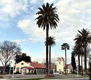
Perris is an old railway city in Riverside County, California, United States, located 71 miles (114 km) east-southeast of Los Angeles and 81 miles (130 km) north of San Diego. It is known for Lake Perris, an artificial lake, skydiving, Southern California Railway Museum, and its sunny dry climate. Perris is within the Inland Empire metropolitan area of Southern California. Perris had a population of 78,700 as of the 2020 census.
Romoland is a census-designated place (CDP) in Riverside County, California, United States. The population was 2,005 at the 2020 census, up from 1,684 at the 2010 census.

Wildomar is a city in southwest Riverside County, California, United States. The city was incorporated on July 1, 2008. As of the 2020 census, the population was 36,875. The community has grown quickly during the early 21st century; the population has more than doubled since the 2000 census, when the community was still an unincorporated census-designated place.

State Route 74, part of which forms the Palms to Pines Scenic Byway or Pines to Palms Highway, and the Ortega Highway, is a state highway in the U.S. state of California. It runs from Interstate 5 in San Juan Capistrano in Orange County to the city limits of Palm Desert in Riverside County. Stretching about 111 miles (179 km), it passes through several parks and National Forests between the Pacific coast and the Coachella Valley.
Lake Elsinore Unified School District is a public school district located in Lake Elsinore, California, USA. It was formed on July 1, 1989, when the Elsinore Union High School District merged with the Lake Elsinore School District (elementary). The Lake Elsinore Unified School District is the 8th largest school district in Riverside County and encompasses an area of 131.78 square miles.
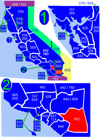
Area code 951 is a telephone area code in the North American Numbering Plan for western Riverside County in the southern part of the U.S. state of California. It was assigned in 2004 to a new numbering plan area that was created by an area code split of area code 909.

The San Jacinto River is a 42-mile-long (68 km) river in Riverside County, California. The river's headwaters are in Santa Rosa and San Jacinto Mountains National Monument. The lower portion of the 765-square-mile (1,980 km2) watershed is urban and agricultural land. As a partially endorheic watershed that is contiguous with other Great Basin watersheds, the western side of the San Jacinto Basin is a portion of the Great Basin Divide.
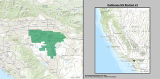
California's 41st congressional district is a congressional district in Riverside County, in the U.S. state of California. The district is currently represented by Republican Ken Calvert.

Menifee is a city in Riverside County, California, United States, and is part of the Inland Empire. Named after a local miner, Luther Menifee Wilson, it was settled in the 19th century, and established as an independent city in 2008. Since then, Menifee has become one of the fastest growing cities in California and the United States.

The Eastern Municipal Water District of Southern California is a regional water district formed in 1950 to secure additional water for a largely rural area of western Riverside County. In addition to water service, responsibilities include sewage collection, water desalination and water recycling.
Menifee Union School District is a school district located in the city of Menifee, California, serving grades K-8. The district plans on adding at least two more schools in addition to the ones listed below.
The Perris Elementary School District is the organization responsible for the administration of public elementary schools (K-6) in the city of Perris, California in the United States. The district currently administers eight elementary schools.
The Riverside County Office of Education (RCOE) serves as an intermediary between the California Department of Education and local school districts. It provides a wide range of educational and administrative services to the 23 school districts and more than 423,000 students in Riverside County.

The San Jacinto Valley is a valley located in Riverside County, in Southern California, in the Inland Empire. The valley is located at the base of the San Jacinto Mountains in the east and Santa Rosa Hills to the south with the San Gorgonio Pass to the north. The average elevation is 1,500 feet (460 m), with the highest points in the foothills south of Hemet and the western slopes of the San Jacinto Mountains. It is home to two cities, Hemet and San Jacinto, and several unincorporated communities. According to the 2020 census, the valley has a combined population of over 190,000 residents, including more than 143,000 residents within the city limits of Hemet and San Jacinto. The valley is also where the story and play "Ramona" was set; the story was written after author Helen Hunt Jackson visited the valley in the 1880s. The valley is also known for being an area of agriculture, which has given way to more urbanized development.

Riverside County is a county located in the southern portion of the U.S. state of California. As of the 2020 census, the population was 2,418,185, making it the fourth-most populous county in California and the 10th-most populous in the United States. The name was derived from the city of Riverside, which is the county seat.

French Valley is a census-designated place located in the French Valley of Riverside County, California. The 2020 United States census reported French Valley's population as 35,280, up from 23,067 at the 2010 census. It became the most populous CDP in Riverside County when Rubidoux was incorporated into Jurupa Valley.
Romoland School District is a TK–8 public school district based in Riverside County, California, United States serving over 4,500 students.
The Perris Block is the central block of three major fault-bounded blocks of the northern part of the Peninsular Ranges. The Perris Block lies between the Santa Ana Block to the west and the San Jacinto Block to the east. The Perris Block, was named by Walter A. English in 1925 for the city of Perris, located near the center of the block.