Petworth Canal

Last updated

The canal near Haines Cottages Haslingbourne Stream at Haines.JPG
The canal near Haines Cottages
Petworth Canal
BSicon WASSER.svg
Haslingbourne Stream
BSicon uSKRZ-Yu.svg
Haslingbourne Bridge
BSicon ueWHARF.svg
Terminates at former wharf 1¼ miles
BSicon uSTR.svg
BSicon uSTR.svg
BSicon uLock5.svg
Lock
BSicon ueTEEnl.svg
BSicon uSTR.svg
BSicon uSTR.svg
BSicon uWEIRr.svg
BSicon WASSERq.svg
Haslingbourne Stream
BSicon ugLock5.svg
Lock
BSicon gSTR.svg
BSicon gSTR.svg
BSicon WASSERq.svg
BSicon gSTR.svg
BSicon WASSERq.svg
Culvert
BSicon gSTR.svg
BSicon gSTR.svg
BSicon uSTR+l.svg
BSicon uxWEIRr.svg
BSicon ugFABZgr+r.svg
(silted up)To River Rother
BSicon ugFABZqlr.svg
BSicon uFABZqlr.svg
Junction with Rother Navigation

The Petworth Canal was one of Britain's shorter lasting canals, opened in 1795 and dismantled in 1826. Upon completion of the Rother Navigation, the Earl of Egremont used his estate workforce to build the 1¼ mile long canal from just upstream of the Shopham Cut to Haslingbourne, with two locks, each with a rise of 8 feet and 6 inches. The Haslingbourne Stream was diverted to provide the water supply, and still flows in the canal bed from Haslingbourne to the site of Haines Lock. The initial intention was to extend the canal through the Shimmings Valley to Hamper's Green on the north side of Petworth, then northwards to join the Wey Navigation at Shalford.

George Wyndham, 3rd Earl of Egremont British earl

George O'Brien Wyndham, 3rd Earl of EgremontFRS of Petworth House in Sussex and Orchard Wyndham in Somerset, was a British peer, a major landowner and a great art collector. He was interested in the latest scientific advances. He was an agriculturist and a friend of the agricultural writer Arthur Young, and was an enthusiastic canal builder who invested in many commercial ventures for the improvement of his estates. He played a limited role in politics.

Petworth town and in the Chichester District of West Sussex, England

Petworth is a small town and civil parish in the Chichester District of West Sussex, England. It is located at the junction of the A272 east-west road from Heathfield to Winchester and the A283 Milford to Shoreham-by-Sea road. Some twelve miles (21 km) to the south west of Petworth along the A285 road lies Chichester and the south-coast. The parish includes the settlements of Byworth and Hampers Green and covers an area of 2,690 hectares. In 2001 the population of the parish was 2,775 persons living in 1,200 households of whom 1,326 were economically active. At the 2011 Census the population was 3,027.

Shalford, Surrey village in Surrey, United Kingdom

Shalford is a village and civil parish in Surrey, England on the A281 Horsham road immediately south of Guildford. It has a railway station which is between Guildford and Dorking on the Reading to Gatwick Airport line.

Contents

Construction of the branch to Haslingbourne bridge was included in the Act of Parliament, [1] numbered [2151] passed in 1791, titled;

An act of parliament, also called primary legislation, are statutes passed by a parliament (legislature). Act of the Oireachtas is an equivalent term used in the Republic of Ireland where the legislature is commonly known by its Irish name, Oireachtas. It is also comparable to an Act of Congress in the United States.

"An Act to enable the Earl of Egremont to make and maintain the River Rother navigable, from the Town of Midhurst, to a certain Meadow, called the Railed Pieces, or Stopham Meadow in the Parish of Stopham, and a navigable Cut, from the said River to the River Arun, at or near Stopham Bridge, in the county of Sussex; and for other Purposes."

Construction

Digging began early in 1795, employing about twenty navvies. In August lock gates were being hung and a bridge built at Haines Lock. Sandstone from the nearest quarries at Fittleworth and Upperton would have been used for the bridges and locks. Coping stones are recorded as being barged from Todham and Moorland locks near Midhurst by Edmund Sayer. The navigation was open by October 1795.

Fittleworth village in the United Kingdom

Fittleworth is a village and civil parish in the District of Chichester in West Sussex, England located seven kilometres (3 miles) west from Pulborough on the A283 road and three miles (5 km) south east from Petworth. The village has an Anglican church, a primary school and one pub, The Swan. It is within the ancient divisions of the Bury Hundred and the Rape of Arundel. The village is bounded south by the Rother Navigation.

Upperton, West Sussex village in United Kingdom

Upperton is a hamlet in the Chichester district of West Sussex, England. Part of Tillington civil parish it lies on the Tillington to Lurgashall road 1.4 miles (2.2 km) northwest of Petworth.

Coping (architecture) covering for the top of a wall

Coping consists of the capping or covering of a wall.

Plans for extension

The Earl of Egremont wanted a safe inland waterway that would link London on the River Thames with the south coast and the naval base at Portsmouth. Coastal shipping at that time faced serious hazards such as the notorious Goodwin Sands, where the Earl's own two-year-old brigantine Egremont was wrecked in 1797. During wars with France there were military dangers as well. The initial intention was to extend the canal through the Shimmings Valley to Hamper's Green on the north side of Petworth, then northwards to join the Wey Navigation at Shalford. [2] Canal engineer William Jessop believed a route could be found past Northchapel, Shillinglee, Dunsfold and Alfold, then following the Cranleigh stream through Bramley to Shalford. A branch from Alfold to Horsham was also proposed. Agriculturalist Arthur Young advocated the scheme as a means to bring lime for the farms to improve their productivity. The Earl's estate surveyor Thomas Upton carried out a more detailed survey in 1793 and concluded that the 32 mile route would rise some 220 feet to cross the watershed into Surrey, with as many as nine locks needed just to climb 58 feet to the north side of Petworth. He suggested that a 17-mile extension of the Arun Navigation from Newbridge to the River Wey would be more practical. Even in that year when Canal Mania was at its height it was apparent that extension of the Petworth Canal could not be cost effective.

River Thames river in southern England

The River Thames, known alternatively in parts as the Isis, is a river that flows through southern England including London. At 215 miles (346 km), it is the longest river entirely in England and the second longest in the United Kingdom, after the River Severn.

Portsmouth City & unitary authority area in England

Portsmouth is a port city in Hampshire, England, with a total population of 205,400 residents. The city of Portsmouth is nicknamed Pompey and is mainly built on Portsea Island, a flat, low-lying island measuring 24 square kilometres in area, just off the south-east coast of Hampshire. Uniquely, Portsmouth is the only island city in the United Kingdom, and is the only city whose population density exceeds that of London.

Goodwin Sands

Goodwin Sands is a 10-mile (16 km) long sandbank at the southern end of the North Sea lying 6 miles (10 km) off the Deal coast in Kent, England. The area consists of a layer of approximately 25 m (82 ft) depth of fine sand resting on an Upper Chalk platform belonging to the same geological feature that incorporates the White Cliffs of Dover. The banks lie between 0.5 m above the low water mark to around 3 m (10 ft) below low water, except for one channel that drops to around 20 m (66 ft) below. Tides and currents are constantly shifting the shoals.

Trade

The main products carried on the canal were chalk, coal and timber. Coal from Newcastle or South Wales was transferred from coastal ships into barges at Arundel. Chalk was barged up the River Arun from pits leased and operated by the Earl at Houghton and Amberley. Timber and all kinds of timber products, including charcoal and oak bark for tanning were barged out from the Peworth area, although there are few records of what passed through Haslingbourne. A lime kiln was operated at Haslingbourne wharf, [3] and some lime barged down the canal. Most of the Petworth trade however went to Coultershaw wharf on the Rother navigation, which was further away from the town but was on the well maintained turnpike road to Chichester. There was no extra toll for using the Petworth canal but this also saved the barge masters having to travel through two locks. From east of Petworth it was often cheaper to cart goods to and from the River Arun, which was free of tolls below Pallingham, avoiding the Rother Navigation tolls payable on passing through Stopham Lock.

Chalk A soft, white, porous sedimentary rock made of calcium carbonate

Chalk is a soft, white, porous, sedimentary carbonate rock, a form of limestone composed of the mineral calcite. Calcite is an ionic salt called calcium carbonate or CaCO3. It forms under reasonably deep marine conditions from the gradual accumulation of minute calcite shells (coccoliths) shed from micro-organisms called coccolithophores. Flint (a type of chert) is very common as bands parallel to the bedding or as nodules embedded in chalk. It is probably derived from sponge spicules or other siliceous organisms as water is expelled upwards during compaction. Flint is often deposited around larger fossils such as Echinoidea which may be silicified (i.e. replaced molecule by molecule by flint).

Newcastle upon Tyne City and metropolitan borough in England

Newcastle upon Tyne, commonly known as Newcastle, is a city in Tyne and Wear, North East England, 103 miles (166 km) south of Edinburgh and 277 miles (446 km) north of London on the northern bank of the River Tyne, 8.5 mi (13.7 km) from the North Sea. Newcastle is the most populous city in the North East, and forms the core of the Tyneside conurbation, the eighth most populous urban area in the United Kingdom. Newcastle is a member of the UK Core Cities Group and is a member of the Eurocities network of European cities.

South Wales Region of Wales

South Wales is the region of Wales bordered by England and the Bristol Channel to the east and south, mid Wales to the north, and west Wales to the west. With an estimated population of around 2.2 million, which is almost three-quarters of the whole of Wales, Cardiff has approximately 400,000, Swansea has approximately 250,000 and Newport has 150,000. The region is loosely defined, but it is generally considered to include the historic counties of Glamorgan and Monmouthshire, extending westwards to include Carmarthenshire and Pembrokeshire. In the western extent, from Swansea westwards, local people would probably recognise that they lived in both south Wales and west Wales. The Brecon Beacons national park covers about a third of South Wales, containing Pen y Fan, the highest British mountain south of Cadair Idris in Snowdonia.

Closure

Dredging was carried out in 1824 and the banks repaired, [4] but when repairs to locks on the Rother navigation were urgently needed in 1826 the Earl decided to close the underused canal and reuse materials from the locks, which were completely dismantled that summer. This paid no regard to the landowner's legal duty to maintain the navigation. The cutting across the field below Haines Lock was then filled in.

The canal today

The canal channel on the Rother floodplain Petworth Canal on Rother floodplain.JPG
The canal channel on the Rother floodplain

The wharf at Haslingbourne has entirely disappeared and an electricity sub-station and a former water treatment plant, which pumped water from springs at the foot of Gore Hill to Petworth, are on the site. The area is now used for storage of construction machinery. Below Haslingbourne Cottages the stream flows in the canal bed which is cut through sandstone beds, creating a shaded artificial gorge rich in mosses and lichens. Emerging from this cutting at the site of Upper Lock the canal follows a straight course across low lying boggy ground, fenced off as a nature reserve area. Reaching the site of Haines Lock the stream can be heard pouring through a broken down weir in the undergrowth as it turns eastward into its natural course. The west bank of the canal here runs into the pasture for some twenty metres and the position of the levelled course beyond can just be discerned. Beyond the slightly higher ground here, as the Haslingbourne Stream again comes close to the canal, the embankments can be seen forming a straight line across the floodplain to the river. A pond near the river is the site of a weir and tumblebay.

Related Research Articles

Portsmouth and Arundel Canal

The Portsmouth and Arundel Canal was a canal in the south of England that ran between Portsmouth and Arundel, it was built in 1823 but was never a financial success and was abandoned in 1855; the company was wound up in 1888. The canal was part of a larger scheme for the construction of a secure inland canal route from London to Portsmouth, which allowed craft to move between the two without having to venture into the English Channel and possibly encounter enemy ships or natural disaster. It was built by the Portsmouth & Arundel Navigation company. The canal was made up of three sections: a pair of ship canals, one on Portsea Island and one to Chichester, and a barge canal that ran from Ford on the River Arun to Hunston where it joined the Chichester section of the canal.

River Arun river in the United Kingdom

The River Arun is a river in the English county of West Sussex. At 37 miles (60 km) long, it is the longest river entirely in Sussex and one of the longest starting in Sussex after the River Medway, River Wey and River Mole. From the series of small streams that form its source in the area of St Leonard's Forest in the Weald, the Arun flows westwards through Horsham to Nowhurst where it is joined by the North River. Turning to the south, it is joined by its main tributary, the western River Rother, and continues through a gap in the South Downs to Arundel to join the English Channel at Littlehampton. It is one of the faster flowing rivers in England, and is tidal as far inland as Pallingham Quay, 25.5 miles (41.0 km) upstream from the sea at Littlehampton. The Arun gives its name to the Arun local government district of West Sussex.

Limehouse Cut

The Limehouse Cut is a largely straight, broad canal in the East End of London, England, which linked the lower reaches of the Lee Navigation to the River Thames. It now connects to Limehouse Basin as a result of changes made in 1968.

Lee Navigation

The Lee Navigation is a canalised river incorporating the River Lea. It flows from Hertford Castle Weir to the River Thames at Bow Creek; its first lock is Hertford Lock and its last Bow Locks.

River Rother, West Sussex river in West Sussex

The River Rother flows from Empshott in Hampshire, England, to Stopham in West Sussex, where it joins the River Arun. At 52 kilometres (32 mi) long, most of the river lies within West Sussex except for the first 10 kilometres (6.2 mi) which lie in Hampshire. The upper river, from its source to Midhurst, has been used to power watermills, with the earliest recorded use being in 1086, when the Domesday survey was conducted. Although none are still operational, many of the buildings which housed the mills still exist, and in some cases, still retain their milling machinery. This upper section is also noted for a number of early bridges, which have survived since their construction in the fifteenth, sixteenth and seventeenth centuries.

Chichester District Non-metropolitan district in England

Chichester is a largely rural local government district in West Sussex, England. Its council is based in the city of Chichester.

Wey and Arun Canal

The Wey and Arun Canal is a partially restored, 23-mile-long (37 km) canal in the south east of England. It runs southwards from the River Wey at Shalford, Surrey to the River Arun at Pallingham, in West Sussex. The canal comprises parts of two separate undertakings – the northern part of the Arun Navigation, opened in 1787 between Pallingham and Newbridge Wharf, and the Wey and Arun Junction Canal, opened in 1816, which connected the Arun at Newbridge to the Godalming Navigation near Shalford, south of Guildford. The canal was built with 26 locks.

Thames Path long-distance trail following the River Thames in England

The Thames Path is a National Trail following the River Thames from its source near Kemble in Gloucestershire to the Thames Barrier at Charlton, south east London. It is about 184 miles (296 km) long. A path was first proposed in 1948 but it only opened in 1996.

Lodsworth village in the United Kingdom

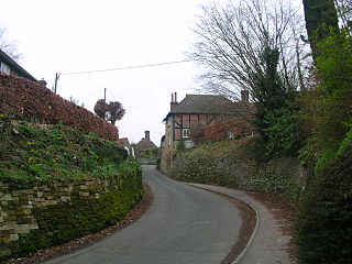
Lodsworth is a small village and civil parish in the Chichester district of West Sussex, England. It is situated between Midhurst and Petworth, half a mile north of the A272 road. It lies within the South Downs National Park, just to the north of the valley of the River Rother and a tributary stream the River Lod runs close to the east end of the village.

London to Portsmouth canal

The London to Portsmouth canal was a proposal for the construction of a secure inland canal route from the capital London to the headquarters of the Royal Navy at Portsmouth. It would have allowed craft to move between the two without having to venture into the English Channel and possibly encounter enemy ships. There is no naturally navigable route between the two cities, resulting in several schemes.

Wey and Godalming Navigations

The River Wey Navigation and Godalming Navigation, geographically the Wey Navigation, form a continuous waterway which provides a 20-mile (32 km) navigable route from the River Thames between Weybridge and Hamm Court, Addlestone via Guildford to Godalming. The waterway is in Surrey and is owned by the National Trust. The Wey Navigation connects to the Basingstoke Canal at West Byfleet, and the Godalming Navigation part to the Wey and Arun Canal in the Broadford part of Shalford. The Navigations consist of man-made canal and adapted parts of the River Wey. Its adjoining path is part of European long-distance path E2.

Dapdune Wharf

Dapdune Wharf is a former wharf on the Wey and Godalming Navigations in Guildford, England, UK, close to the Surrey County Cricket Club ground. It is now maintained by the National Trust.

Stopham village in the United Kingdom

Stopham is a hamlet and civil parish in the District of Chichester in West Sussex, England, about 1.5 miles (2.4 km) west of Pulborough on the A283 road. It is in the civil parish of Fittleworth.

River Wey river in Surrey, United Kingdom

The River Wey is a tributary of the River Thames in south east England and one of two major tributaries in Surrey. The name is of unknown origin and meaning. It begins as two branches rising outside the county which join at Tilford between Guildford and Farnham. Once combined the flow is eastwards then northwards via Godalming and Guildford to meet the Thames while in Surrey. The main sub-tributary is the Tillingbourne flowing from the western slopes of Leith Hill in Surrey westwards to a point just south of Guildford between the main village of Shalford and the hamlet of Peasmarsh. Downstream the river forms the backdrop to Newark Priory and Brooklands.

<i>Perseverance IV</i>

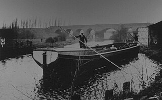
Perseverance IV is a preserved Wey barge, moored at Dapdune Wharf on the River Wey. She was the final barge to leave the historic yards at Dapdune, Guildford, in 1966. She is on the National Register of Historic Ships under registration number 2080, but does not form part of the National Historic Fleet.

Rotherbridge village in the United Kingdom

Rotherbridge is a small, rural community situated approximately 1 mile (1.6 km) south-west of Petworth in West Sussex, England. Until 1800, the road from Chichester to Petworth crossed the River Rother by a bridge here; the river acquired its present name from the bridge. Rotherbridge also gave its name to the Hundred of Rotherbridge which comprised several of the surrounding villages, as well as the town of Petworth.

Coultershaw Wharf and Beam Pump Rural community in England

Coultershaw Bridge is a rural community situated 1.5 mi (2.4 km) south of the town Petworth in West Sussex, England where the A285 road from Petworth to Chichester crosses the River Rother.

Barges of the Wey Navigation

The Wey barge was based on the earlier West Country barge designs and the first barges built specifically for use on the Wey were probably built at Honeystreet Wharf, near Devizes. The earliest that this could be was 1810 as the Kennet and Avon Canal was opened through to the Thames that year.

References

  1. Act of Parliament [2151] of 1791
  2. P A L Vine, London's Lost Route to Midhurst The Earl of Egremont's Navigation pp 64-67
  3. P A L Vine, London's Lost Route to Midhurst The Earl of Egremont's Navigation p 73
  4. P A L Vine, London's Lost Route to Midhurst The Earl of Egremont's Navigation p 73

Coordinates: 50°57′51″N0°36′10″W / 50.96417°N 0.60278°W / 50.96417; -0.60278