Phillips-Williams Fork Reservoir Site

Last updated

The Phillips-Williams Fork Reservoir site (5GA1955) is a Paleoindian site located on the shore of the Williams Fork Reservoir, about 20 kilometers (12 mi) southeast of Kremmling at an elevation of 2400 m (7874 ft.) in Grand County, Colorado, near the center of Middle Park.

Williams Fork Reservoir

Williams Fork Reservoir, located near the town of Parshall in Grand County, Colorado, is owned and operated by Denver Water. The reservoir impounds the Williams Fork of the Colorado River.

Kremmling, Colorado Statutory Town in Colorado, United States

The Town of Kremmling is a Statutory Town in Grand County, Colorado, United States. The town population was 1444 at the 2010 United States Census. The town sits along the upper Colorado River in the lower arid section of Middle Park between Byers Canyon and Gore Canyon. The town was founded in 1881 during the Colorado Silver Boom days, but the lack of mineral resources in the nearby mountains made the town grow very slowly in the early days.

Grand County, Colorado County in the United States

Grand County is one of the 64 counties in the U.S. state of Colorado. As of the 2010 census, the population was 14,843. The county seat is Hot Sulphur Springs.

Contents

Projectile points were found on the site from the James Allen complex (generally 9350 – 7900 before present) and Goshen / Plainview (generally 11,000 before present).

Projectile point object that was hafted to a projectile

In archaeological terms, a projectile point is an object that was hafted to weapon that was capable of being thrown or projected, such as a spear, dart, or arrow, or perhaps used as a knife. They are thus different from weapons presumed to have been kept in the hand, such as axes and maces, and the stone mace or axe-heads often attached to them.

The Goshen point is a medium-sized, lanceolate-shaped, Paleo-Indian projectile point with a straight or concave base. It exhibits characteristic fine flaking.

Plainview point

In the classification of Archaeological cultures of North America, the term Plainview points refer to Paleoindian projectile points dated between 10,000–9,000 Before Present. The point was named in 1947 after the discovery of a large cache of unfluted, lanceolate spear tips with concave bases that were found in a Bison antiquus kill site along the Running Water Draw river, near the town of Plainview in Texas, United States. The point is found primarily throughout the South Plains, however, this range may sometimes be misidentified, as "Plainview" was previously used as a general term to describe unfluted lanceolate points throughout the entirety of the Plains, as well as the eastern Upper Mississippi Valley.

Geography

The Phillips-William site sits on a terrace between the Colorado River and the Williams Fork Tributary. The area surrounding the intersection of these two drainages maintains a relatively flat slope for 5–10 miles in every direction until the terraces intersect the Front Range to the east, the Rabbit Ears Range to the North and the Gore Range to the southwest.

Colorado River major river in the western United States and Mexico

The Colorado River is one of the principal rivers in the Southwestern United States and northern Mexico. The 1,450-mile-long (2,330 km) river drains an expansive, arid watershed that encompasses parts of seven U.S. and two Mexican states. Starting in the central Rocky Mountains of Colorado, the river flows generally southwest across the Colorado Plateau and through the Grand Canyon before reaching Lake Mead on the Arizona–Nevada border, where it turns south toward the international border. After entering Mexico, the Colorado approaches the mostly dry Colorado River Delta at the tip of the Gulf of California between Baja California and Sonora.

Front Range mountain range of the Southern Rocky Mountains of North America

The Front Range is a mountain range of the Southern Rocky Mountains of North America located in the central portion of the U.S. State of Colorado, and southeastern portion of the U.S. State of Wyoming. It is the first mountain range encountered as one goes westbound along the 40th parallel north across the Great Plains of North America.

Rabbit Ears Range

The Rabbit Ears Range is a mountain range of the Rocky Mountains in north central Colorado in the United States. The range stretches east-west along the continental divide forming the border between Grand and Jackson Counties, separating Middle Park (south) from North Park (north). The range connects the Front Range on the east with the Park Range and the Gore Range on the west. It is traversable at Willow Creek Pass. Muddy Pass separates the Rabbit Ears range to the east from the Park Range to the north. Rabbit Ears Pass, and Rabbit Ears Peak, despite their names, are not in the Rabbit Ears Range, but actually reside in the Park Range to the south.

History

Discovery

The Phillips-Williams Fork Reservoir Site was discovered and collected over a five-year period by Ralph and Ruth Phillips, husband and wife. No excavations have been conducted at the site and all specimens are reported as being recovered during surface collection.

Artifacts

The Phillips-Williams Fork Reservoir site assemblage is dominated by James Allen projectile points although two specimens resembling the Goshen/Plainview type were also recovered. Despite the presence of parallel-oblique flaking, some of the points reflect morphological variability that does not allow a quick assignment to the James Allen category. Wiesend and Frison (1998:19) refer to these points as falling within the “grey area” of the James Allen type classification. Despite variations among the 30 specimens, metric analyses showed that the specimens were indeed of the James Allen and Goshen/Plainview types.

George Carr Frison is an American archaeologist. He has been given the Society for American Archaeology's Lifetime Achievement Award, the Paleoarchaeologist of the Century Award, and was elected to the National Academy of Sciences. He was Wyoming’s first State Archaeologist, and was a founder of the University of Wyoming Anthropology Department.

The single publication on the Phillips-Williams Fork Reservoir site assemblage reports 28 projectile points of the James Allen variety and 2 projectile points of the Goshen/Plainview variety. Currently, there is no information about other recovered tool forms or debitage from the site.

Debitage

Debitage is all the material produced during the process of lithic reduction and the production of chipped stone tools. This assemblage includes, but is not limited to, different kinds of lithic flakes and lithic blades, shatter and production debris, and production rejects.

Relative dates for both categories have been established using radiocarbon dates from sites with similar assemblages from Colorado, Wyoming, Kansas, Montana, and elsewhere. These dates are 9350 – 7900 radiocarbon years for Jimmy Allen (Pitblado 2003) and 11,000 radiocarbon years for Goshen/Plainview (Frison 1991).

Wyoming State of the United States of America

Wyoming is a state in the mountain region of the western United States. The state is the 10th largest by area, the least populous, and the second most sparsely populated state in the country. Wyoming is bordered on the north by Montana, on the east by South Dakota and Nebraska, on the south by Colorado, on the southwest by Utah, and on the west by Idaho and Montana. The state population was estimated at 577,737 in 2018, which is less than 31 of the most populous U.S. cities including Denver in neighboring Colorado. Cheyenne is the state capital and the most populous city, with an estimated population of 63,624 in 2017.

Kansas State of the United States of America

Kansas is a U.S. state in the Midwestern United States. Its capital is Topeka and its largest city is Wichita, with its most populated county being Johnson County. Kansas is bordered by Nebraska on the north; Missouri on the east; Oklahoma on the south; and Colorado on the west. Kansas is named after the Kansas River, which in turn was named after the Kansa Native Americans who lived along its banks. The tribe's name is often said to mean "people of the (south) wind" although this was probably not the term's original meaning. For thousands of years, what is now Kansas was home to numerous and diverse Native American tribes. Tribes in the eastern part of the state generally lived in villages along the river valleys. Tribes in the western part of the state were semi-nomadic and hunted large herds of bison.

Montana State of the United States of America

Montana is a landlocked state in the Northwestern United States. Montana has several nicknames, although none are official, including "Big Sky Country" and "The Treasure State", and slogans that include "Land of the Shining Mountains" and more recently "The Last Best Place".

No faunal remains have been reported for this site.

Historical significance

The Phillips-Williams Fork Reservoir site provides archaeologists with the opportunity to assess the extent to which James Allen (and perhaps earlier) groups were utilizing mountain settings during the early Holocene period. When compared to other, similar sites in Colorado, the frequency of points in the Phillips-Williams Fork Reservoir site assemblage is most similar to assemblages from large, communal bison kills in the eastern portions of the state. The absence of evidence for a bison (or other species) kill site and the low occurrence of impact fractures (a common result of point use in hunting) on points raises questions about the nature of the collection. The presence of bend breaks (breaks causing during manufacture) indicates the site may have acted as some sort of temporary camp. The additional presence of Goshen/Plainview points at the Phillips-Williams Fork Reservoir is important as it indicates that the site was either multi-component, that individuals were finding and reusing older projectile points, or that the Goshen/Plainview form may have continued or been adopted by flintknappers of later periods.

See also

Related Research Articles

Clovis point characteristically fluted projectile points associated with the Clovis culture, present in dense concentrations across North America and in northern South America, dating to the Early Paleoindian period roughly 13,500 to 12,800 calendar years ago

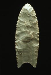
Clovis points are the characteristically-fluted projectile points associated with the New World Clovis culture. They are present in dense concentrations across much of North America; in South America, they are largely restricted to the north of that continent. Clovis points date to the Early Paleoindian period roughly 13,500 to 12,800 calendar years ago. Clovis fluted points are named after the city of Clovis, New Mexico, where examples were first found in 1929 by Ridgely Whiteman.

Folsom tradition Paleo-Indian archaeological culture that occupied much of central North America

The Folsom Complex is a name given by archaeologists to a specific Paleo-Indian archaeological culture that occupied much of central North America. The term was first used in 1927 by Jesse Dade Figgins, director of the Colorado Museum of Natural History.

The San Dieguito Complex is an archaeological pattern left by early Holocene inhabitants of Southern California and surrounding portions of the Southwestern United States and northwestern Mexico. Radiocarbon dating places a 10,200 BP date consideration.

Meadowcroft Rockshelter

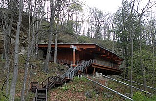
Meadowcroft Rockshelter is an archaeological site located near Avella in Jefferson Township, Washington County, Pennsylvania, United States. The site is a rock shelter in a bluff overlooking Cross Creek, and contains evidence that the area may have been continually inhabited for more than 19,000 years. If accurately dated, the site would be the earliest known evidence of human presence and the longest sequence of continuous human occupation in the New World.

Stanfield-Worley Bluff Shelter

The Stanfield-Worley Bluff Shelter, located on private property in Colbert County in northwestern Alabama, United States, is one of the most important prehistoric sites excavated in the state due to the archeological evidence deposited by the Paleo-Indians who once occupied the rock shelter. Lying in Sanderson Cove along a tributary of Cane Creek approximately seven miles (11 km) south of the Tennessee Valley, the shelter and the high bluffs of the surrounding valley provided a well-protected environment for the Native American occupants.

Clary Ranch, formerly a private cattle ranch, is a site of multiple archaeological digs, many of which produced significant artifacts and remains.

Thunderbird Archaeological District

The Thunderbird Archaeological District, near Limeton, Virginia, is archaeological district described as consisting of "three sites--Thunderbird Site, the Fifty Site, and the Fifty Bog--which provide a stratified cultural sequence spanning Paleo-Indian cultures through the end of Early Archaic times with scattered evidence of later occupation."

J&J Hunt Site (8JE740) is an inundated prehistoric archaeological site located 6 km off the coast of northwestern Florida. The site which was discovered in 1989 is located in 3.7 to 4.6 m of salt water in the Gulf of Mexico along the PaleoAucilla River. In prehistory the site had at least two different occupations: a Late Paleoindian-Early Archaic and Middle Archaic. The J&J Hunt site was a major focus of the PaleoAucilla Prehistory Project conducted by Dr. Michael K. Faught.

Cueva Fell Cave and archaeological site in Patagonia

Cueva Fell is a natural cave and archaeological site in southern Patagonia. Cueva Fell is in proximity to the Pali Aike Crater, another significant archaeological site. Cueva Fell combined with the nearby Pali Aike site have been submitted to UNESCO as a possible World Heritage Site.

St. Mary Reservoir is a reservoir in southwestern Alberta, Canada. It was created for irrigation purposes by the damming of the St. Mary River, which was completed in 1951. The Kainai Nation's Blood 148 Indian reserve borders its northwest side. There are camping and picnic areas at the reservoir, and it is a popular site for power boating, water skiing, windsurfing, swimming and fishing.

Golondrina point

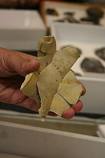
Golondrina points are lanceolate spear or dart projectile points, of medium size, dated to the transitional Paleo-Indian Period, between 9000–7000 BP. Golondrina points were attached on split-stem hafts and may have served to bring down medium-sized animals such as deer, as well as functioning as butchering knives. Distribution is widespread throughout most of Texas, and points have also been discovered in Arkansas and Mexico. The concentration of Golondrina specimens is highest across the South Texas Plains, where the point is the most prevalent of Paleo-Indian types and defines a distinctive cultural pattern for the region. The Golondrina point is so named for its flared basal corners ("ears"), which resemble a swallow's split tail. Classification of Golondrina can be difficult because of its similarity to other types, particularly the Plainview point, to which it was originally thought to be related.

The Paleoindian Database of the Americas (PIDBA), is a website dedicated to the compilation of projectile point and other relevant data pertaining to Paleoindian site assemblages across the Americas. As of April 2011, the PIDBA database contains information pertaining to locational data (n=29,393), attribute data (n=15,254), and image data on Paleoindian projectile points and other tools in North America and also includes bibliographic references, radiocarbon dates, and maps created making use of database and GIS data. The PIDBA site provides a database that is useful in studying stylistic and morphological variability, lithic raw material usage and procurement strategies, geographic distributions of technology, and land use strategies during the Paleoindian period, which took place prior to ca. 11,450 cal year BP. The PIDBA database also serves a function as an intermediary between academic and advocational archaeologists in the collection and integration of primary projectile point data. Overall, the PIDBA project aims to compile data from multiple sources into a comprehensive database, while simultaneously seeking out and including new data. The PIDBA website contains a large amount of primary data collected and donated by researchers and advocational archaeologists from all over the Americas ranging from metric measurements to the type of chert any particular piece is made from. It is the voluntary contributions of primary data from these researchers that makes PIDBA possible. While it is understandable that researchers would like to fully examine and publish on their data, the site’s philosophy is that it is important to disseminate information freely, so that other researchers can work with it. This allows researchers to make new discoveries that they perhaps would not be possible otherwise.

Jones-Miller Bison Kill Site

The Jones-Miller Bison Kill Site, located in northeast Colorado, was a Paleo-Indian site where Bison antiquus were killed using a game drive system and butchered. Hell Gap complex bones and tools artifacts at the site are carbon dated from about ca. 8000-8050 BC.

Outline of Colorado prehistory

The following outline is provided as an overview of and topical guide to the prehistoric people of Colorado, which covers the period of when Native Americans lived in Colorado prior to contact with the Dominguez-Escalante Expedition in 1776. People's lifestyles included nomadic hunter-gatherering, semi-permanent village dwelling, and residing in pueblos.

Dent Site

Dent Site is a Clovis culture site located in Weld County, Colorado, near Milliken, Colorado. It provided evidence that man and mammoth co-existed in the Americas.

Hell Gap complex is a Plano culture from 10,060 to 9,600 before present. It is named after the Hell Gap archaeological site, in Goshen County, Wyoming.

Hell Gap Archaeological Site

Hell Gap is a deeply stratified archaeological site located in the Great Plains of eastern Wyoming, approximately thirteen miles north of Guernsey, where an abundant amount of Paleoindian and Archaic artifacts have been found and excavated since 1959. This site has had an important impact on North American archaeology because of the large quantity and breadth of prehistoric Paleoindian and Archaic period artifacts and cultures it encompasses. It was designated a National Historic Landmark in 2016.

References