The Pyrenees is a range of mountains in southwest Europe that forms a natural border between Spain and France. Reaching a height of 3,404 metres (11,168 ft) altitude at the peak of Aneto, the range separates the Iberian Peninsula from the rest of continental Europe, and extends for about 491 km (305 mi) from the Bay of Biscay to the Mediterranean Sea.

The Tödi, is a mountain massif and with the mountain peak Piz Russein the highest mountain in the Glarus Alps and the highest summit in the canton of Glarus, Switzerland. It is located on the border between the cantons of Graubünden, to the south, and Glarus, to the north, close to the point where those two cantons meet the canton of Uri, to the west. Although not the culminating point of Graubünden, it is its highest peak outside the Bernina range.

The Diablerets are a huge ice-covered mountain massif of the Alps, culminating at the Sommet des Diablerets at 3,210 metres (10,530 ft) above sea level and straddling the border between the Swiss cantons of Vaud (VD) and Valais (VS). The northeastern part of the massif stretches also into the canton of Bern (BE).

Pico de Orizaba, also known as Citlaltépetl, is a stratovolcano, the highest mountain in Mexico and the third highest in North America, after Denali of Alaska in the United States and Mount Logan of Canada. It rises 5,636 metres (18,491 ft) above sea level in the eastern end of the Trans-Mexican Volcanic Belt, on the border between the states of Veracruz and Puebla. The volcano is currently dormant but not extinct, with the last eruption taking place during the 19th century. It is the second most prominent volcanic peak in the world after Africa's Mount Kilimanjaro.

The Aiguille de Bionnassay is a mountain in the Mont Blanc massif of the Alps in France and Italy. It has been described as "one of the most attractive satellite peaks of Mont Blanc", and is located on its western side. The mountain's south and east ridges form the frontier between the two countries, and its summit is a knife-edge crest of snow and ice. Reaching it via any route provides a "splendid and serious snow and ice climb".

The Grand Combin is a mountain massif in the western Pennine Alps in Switzerland. With its 4,314 metres (14,154 ft) highest summit, the Combin de Grafeneire, it is one of the highest peaks in the Alps and the second most prominent of its range. The Grand Combin is also a large glaciated massif consisting of several summits, among which three are above 4000 metres.

La Meije is a mountain in the Massif des Écrins range, located at the border of the Hautes-Alpes and Isère départements. It overlooks the nearby village of La Grave, a mountaineering centre and ski resort, well known for its off-piste and extreme skiing possibilities, and also dominates the view west of the Col du Lautaret. It is the second highest mountain of the Écrins after Barre des Écrins

The Barre des Écrins is a mountain in the French Alps with a peak at 4102m altitude. It is the highest peak of the Massif des Écrins and the Dauphiné Alps and the most southerly alpine peak in Europe that is higher than 4,000 m. It is the only 4,000 m mountain in France that lies outside the Mont Blanc Massif. Before the annexation of Savoy in 1860 it was the highest mountain in France.
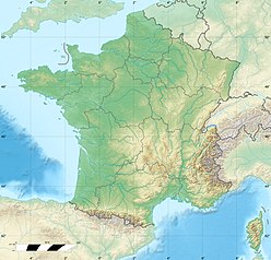
The Pic du Midi d'Ossau is a mountain rising above the Ossau Valley in the French Pyrenees. Despite possessing neither a glacier nor, in the context of the range, a particularly high summit, its distinctive shape makes it a symbol of the French side of the Pyrenees. This familiar shape also makes it easily recognisable from afar, and it is particularly distinctive from the Boulevard des Pyrénées in Pau, some 55 km to the north.

The Mont Blanc massif is a mountain range in the Alps, located mostly in France and Italy, but also straddling Switzerland at its northeastern end. It contains eleven major independent summits, each over 4,000 metres (13,123 ft) in height. It is named after Mont Blanc, the highest point in western Europe and the European Union. Because of its considerable overall altitude, a large proportion of the massif is covered by glaciers, which include the Mer de Glace and the Miage Glacier – the longest glaciers in France and Italy, respectively.

Belledonne is a mountain range in the Dauphiné Alps in southeast France. The southern end of the range forms the eastern wall of the mountains that surround the city of Grenoble.

Wedge Mountain, 2895 m (9497 ft) prominence: 2249 m, often locally referred to as The Wedge or simply "Wedge", is the highest summit in the Garibaldi Ranges and therefore also Garibaldi Provincial Park, and is among the nearest of the many peaks visible from the Whistler Blackcomb Ski Area, lying north across the valley of Billygoat Pass from the Spearhead Range, which includes one of that resort's two flagship mountains, Blackcomb. It was named for its distinctive wedge shape by the Garibaldi Park Board in 1932 in preference to Mount Vancouver, which had been submitted earlier. It is part of an unnamed range forming the most northerly group of peaks in the Garibaldi Ranges, the other two most notable being Mount Weart, known as the Armchair because of its shape, and Mount Currie, which overlooks the First Nations Reserve of the same name and the neighbouring town of Pemberton. Wedge's very high prominence is defined by the divide between the Green and Cheakamus Rivers at a locality at the south end of Alta Lake known as Tokum Corners.

The Ailefroide is a mountain in the Massif des Écrins in the French Alps, and is the third highest peak in the Dauphiné Alps after the Barre des Écrins and La Meije. It lies at the south-western end of the Mont Pelvoux–Pic Sans Nom–Ailefroide ridge.

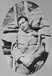
Henry Patrick Marie, Count Russell-Killough (1834–1909) was one of the pioneers of Pyrenean exploration, known for his obsession with the Vignemale.

The Néouvielle massif is a group of mountains in the Pyrenees in France notable for its lakes and its microclimate. Much of the massif lies within the 23.13 square kilometres (8.93 sq mi) Néouvielle National Nature Reserve; this nature reserve was created in 1936 and is the third oldest in France.

White River Glacier is an alpine glacier located on the south slopes of Mount Hood in the U.S. state of Oregon. It ranges in elevation from about 10,000 to 6,200 feet. It is among the best known of the twelve glaciers on the mountain, and the lower reaches are a popular destination for Nordic skiing enthusiasts. The glacier is the source of the White River, a tributary of the Deschutes River, and has a long history of washing out the bridge where Oregon Route 35 crosses at 45.30307°N 121.67208°W.
Henri Cordier or Henry Cordier was a French mountaineer. In his short two-year career, he became the first Frenchman to reach the level of the English members of the Alpine Club, in the silver age of alpinism in the second half of the 19th century, which was dominated by the development of mountaineering in the Alps. With some of the Alpine Club's mountain guides and mountaineers, he led significant first ascents in the Mont Blanc massif and in the Dauphiné Alps.
The Rieserferner Group is a mountain range in the Austrian Central Alps. Together with the Ankogel Group, Goldberg Group, Glockner Group, Schober Group, Kreuzeck Group, Granatspitze Group, Venediger Group and the Villgraten Mountains the group is part of the High Tauern. The Rieserferner mountains extend across the Austrian state of Tyrol and the Italian province of South Tyrol. The mountains mainly lie in South Tyrol, where the greater part is protected within the Rieserferner-Ahrn Nature Park.