Pigeon River (Tennessee–North Carolina)

Last updated

Pigeon River
Pigeon River (Tennessee - North Carolina).jpg
The confluence of the Pigeon River and Big Creek in Waterville, North Carolina. The power plant is in the background.
Pigeon River watershed.jpg
Pigeon River watershed (Interactive map)
Location
Country United States
State North Carolina, Tennessee
Physical characteristics
SourceWest Fork Pigeon River
  locationbelow Mount Hardy in Haywood County, North Carolina
  coordinates 35°18′11″N82°55′05″W / 35.30306°N 82.91806°W / 35.30306; -82.91806 [1]
  elevation5,320 ft (1,620 m)
2nd sourceEast Fork Pigeon River
  locationbelow South Spring Top in Haywood County, North Carolina
  coordinates 35°19′37″N82°49′47″W / 35.32694°N 82.82972°W / 35.32694; -82.82972 [2]
  elevation4,190 ft (1,280 m)
Source confluence 
  locationsouth of Canton, North Carolina
  coordinates 35°28′43″N82°52′55″W / 35.47861°N 82.88194°W / 35.47861; -82.88194 [3]
  elevation2,644 ft (806 m)
Mouth French Broad River
  location
Irish Bottoms in Cocke County, Tennessee
  coordinates
36°01′28″N83°11′47″W / 36.02444°N 83.19639°W / 36.02444; -83.19639 [3]
  elevation
1,001 ft (305 m) [3]
Length70 mi (110 km) [4]
Basin size704 sq mi (1,820 km2) [5]
Discharge 
  location Newport, Tennessee, 6.8 miles (10.9 km) above the mouth(mean for water years 1945–1983) [6]
  average1,256 cu ft/s (35.6 m3/s)(mean for water years 1945–1983) [6]
  minimum38 cu ft/s (1.1 m3/s)October 1952 [6]
  maximum50,000 cu ft/s (1,400 m3/s)February 1902 [6]

The Pigeon River of Western North Carolina and East Tennessee rises above Canton, North Carolina, is impounded by Walters Dam, enters Tennessee, and flows into the French Broad River, just past Newport, Tennessee. The river traverses the Pisgah National Forest and the Cherokee National Forest, and drains much of the northeastern Great Smoky Mountains National Park.

Contents

The river takes its name from the passenger pigeon, an extinct bird whose migration route once included the river valley in North Carolina. [7]

Course

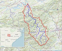
The Pigeon River arises in southeastern Haywood County, North Carolina, and flows basically northwest for most of its length. However, near Pressley Mountain it turns northeast for about four miles and in the town of Canton, where it is utilized by the local paper mill, it turns north. After Canton it turns almost due west for about five miles, before resuming its northwest trend at about Clyde. From Canton, the Pigeon River flows roughly parallel to Interstate 40 for many miles. It is impounded by the Walters Dam of Progress Energy creating the long, narrow Waterville Lake. It enters Tennessee just after the village of Waterville, and continues with I-40 in the same valley northwestward through Hartford to Newport, where I-40 heads west, and the Pigeon River flows north into the French Broad River.

History

The Pigeon River dam was started in 1927 and was completed in 1930. The project was started by Carolina Power & Light and was completed by its affiliate Phoenix Electric Co. The concrete dam is 180 ft (55 m) high by 800 ft long. The brick power plant (visible from I-40) is actually 6.2 miles (10.0 km) from the dam. A tunnel 6.2 miles (10.0 km) long stretches from the dam to the power plant. [8]

The floods following the series of storms spawned by Hurricanes Frances and Ivan in September 2004 have changed the character of the river. The rains lasted days and flooding was severe. Portions of the towns of Canton and Clyde were completely underwater, and there was significant damage to a large portion of both towns. [9] [10] Farther upstream the water levels reached unprecedented levels. Part of Interstate 40 collapsed into the river gorge because of the force of the floodwaters. This began when trees on the hill beside the highway fell in the river, followed by the soil the trees had held in place. The shoulder gave way, and a guardrail ended up just hanging. [11]

A large paper mill (once part of Champion International Paper and now the Blue Ridge Paper Company) in Canton was the primary source of considerable dioxin and particulate matter pollution discharged into the Pigeon River. The pollution situation in the river became a minor issue in the campaign for the 1988 Presidential election. As Al Gore started his first run for the Presidency, Newsweek magazine reported that Gore was pressured by North Carolina Senator Terry Sanford and Congressman Jamie Clarke to ease up on his campaign against Champion's wastewater discharges into the Pigeon River. According to Newsweek, Gore complied with their request, writing to the United States Environmental Protection Agency to oppose tighter water pollution control requirements. [12] This issue came up again during the 2000 Presidential election.

Recreation

Recreational rafting is popular in two sections of the river, the Upper and the Lower. Both sections are found in Hartford, Tennessee. The Upper section begins at the powerhouse (located right on the North Carolina/Tennessee border) and features up to Class III+ whitewater rapids. The Lower section features "more modest" waves. [13]

See also

Related Research Articles

<span class="mw-page-title-main">Canton, North Carolina</span> Town in North Carolina, United States

Canton is the second largest town in Haywood County, North Carolina, United States. It is located about 17 miles (27 km) west of Asheville and is part of that city's metropolitan area. The town is named after the city of Canton, Ohio. The population was 4,227 at the 2010 census.

<span class="mw-page-title-main">Kennebec River</span> River in Maine, United States

The Kennebec River is a 170-mile-long (270 km) river within the U.S. state of Maine. It rises in Moosehead Lake in west-central Maine. The East and West Outlets join at Indian Pond and the river flows southward. Harris Station Dam, the largest hydroelectric dam in the state, was constructed near that confluence. The river is joined at The Forks by its tributary the Dead River, also called the West Branch.

<span class="mw-page-title-main">Little Tennessee River</span> River in the United States of America

The Little Tennessee River is a 135-mile (217 km) tributary of the Tennessee River that flows through the Blue Ridge Mountains from Georgia, into North Carolina, and then into Tennessee, in the southeastern United States. It drains portions of three national forests— Chattahoochee, Nantahala, and Cherokee— and provides the southwestern boundary of the Great Smoky Mountains National Park.

<span class="mw-page-title-main">French Broad River</span> River in North Carolina and Tennessee, United States

The French Broad River is a river in the U.S. states of North Carolina and Tennessee. It flows 218 miles (351 km) from near the town of Rosman in Transylvania County, North Carolina, into Tennessee, where its confluence with the Holston River at Knoxville forms the beginning of the Tennessee River. The river flows through the counties of Transylvania, Buncombe, Henderson, and Madison in North Carolina, and Cocke, Jefferson, Sevier, and Knox in Tennessee. It drains large portions of the Pisgah National Forest and the Cherokee National Forest.

<span class="mw-page-title-main">Rockaway River</span> River in New Jersey, United States

The Rockaway River is a tributary of the Passaic River, approximately 35 mi (56 km) long, in Morris County, New Jersey in the United States. The upper course of the river flows through a wooded mountainous valley, whereas the lower course flows through the populated New Jersey suburbs and former industrial area west of New York City. It drains an area of approximately 130 sq mi (340 km²).

<span class="mw-page-title-main">Lehigh River</span> River in Pennsylvania, United States

The Lehigh River is a 109-mile-long (175 km) tributary of the Delaware River in eastern Pennsylvania. The river flows in a generally southward pattern from the Pocono Mountains in Northeastern Pennsylvania through Allentown and much of the Lehigh Valley before joining the Delaware River in Easton.

<span class="mw-page-title-main">Toccoa/Ocoee River</span> River in Georgia and Tennessee in the United States

The Toccoa River and Ocoee River are the names in use for a single 93-mile-long (150 km) river that flows northwestward through the southern Appalachian Mountains of the southeastern United States. It is a tributary of the Hiwassee River, which it joins in Polk County, Tennessee, near the town of Benton. Three power generating dams are operated along it.

<span class="mw-page-title-main">Watauga River</span> River in the United States of America

The Watauga River is a large stream of western North Carolina and East Tennessee. It is 78.5 miles (126.3 km) long with its headwaters in Linville Gap to the South Fork Holston River at Boone Lake.

<span class="mw-page-title-main">Doe River</span> Tributary of the Watauga River in northeast Tennessee, United States

The Doe River is a tributary of the Watauga River in northeast Tennessee in the United States. The river forms in Carter County near the North Carolina line, just south of Roan Mountain State Park, and flows to Elizabethton.

<span class="mw-page-title-main">Caney Fork River</span> River in Tennessee, United States

The Caney Fork River is a river that flows through central Tennessee in the United States, draining a substantial portion of the southwestern Cumberland Plateau and southeastern Highland Rim regions. It is a major tributary of the Cumberland River, and is part of the Cumberland, Ohio and Mississippi basins. The river is 143 miles (230 km) long, and its watershed covers 1,771 square miles (4,590 km2) in eleven counties. Monterey, Baxter, Sparta, Smithville, McMinnville, Altamont, Spencer and Gordonsville are among the towns that are at least partially drained by the river.

<span class="mw-page-title-main">Nolichucky River</span> River in the Eastern United States

The Nolichucky River is a 115-mile (185 km) river that flows through Western North Carolina and East Tennessee, in the southeastern United States. Traversing the Pisgah National Forest and the Cherokee National Forest in the Blue Ridge Mountains, the river's watershed is home to some of the highest mountains in the Appalachians, including Mount Mitchell in North Carolina, the highest point in the eastern United States. The river is a tributary of the French Broad River, and is impounded by Nolichucky Dam near Greeneville, Tennessee.

<span class="mw-page-title-main">Hiwassee River</span> River in the United States of America

The Hiwassee River originates from a spring on the north slope of Rocky Mountain in Towns County in the northern area of the State of Georgia. It flows northward into North Carolina before turning westward into Tennessee, flowing into the Tennessee River a few miles west of what is now State Route 58 in Meigs County, Tennessee. The river is about 147 miles (237 km) long.

<span class="mw-page-title-main">Cheat River</span> River in West Virginia, United States

The Cheat River is a 78.3-mile-long (126.0 km) tributary of the Monongahela River in eastern West Virginia and southwestern Pennsylvania in the United States. Via the Ohio River, the Cheat and Monongahela are part of the Mississippi River watershed. Owing to the ruggedness of the surrounding Allegheny Mountains, the Cheat remains largely remote with few settlements or developments along its banks. Its headwaters are in the Cheat-Potomac Ranger District of the Monongahela National Forest.

<span class="mw-page-title-main">Black River (New York)</span> River in New York state, United States

The Black River is a 125-mile-long (201 km) blackwater river that empties into the eastern end of Lake Ontario on the shore of Jefferson County, New York in the United States. The origin of the name is not clear, but it may stem from the natural tannic acid that darkens the water in places. The river flows in a generally northwest direction, with its valley dividing the Adirondack Mountains on the east from the Tug Hill region to the west.

<span class="mw-page-title-main">Farmington River</span> River in the United States of America

The Farmington River is a river, 46.7 miles (75.2 km) in length along its main stem, located in northwest Connecticut with major tributaries extending into southwest Massachusetts. The longest route of the river, from the origin of its West Branch, is 80.4 miles (129.4 km) long, making it the Connecticut River's longest tributary by 2.3 miles (3.7 km) over the major river directly to its north, the Westfield River. The Farmington River's watershed covers 609 square miles (1,580 km2). Historically, the river played an important role in small-scale manufacturing in towns along its course, but it is now mainly used for recreation and drinking water.

<span class="mw-page-title-main">Chattooga River</span> River in the Southeastern USA

The Chattooga River is the main tributary of the Tugaloo River.

<span class="mw-page-title-main">Green River (North Carolina)</span> Stream in North Carolina, USA

The Green River is a dam-release river that flows through the mountains of North Carolina, south of Asheville. The Green has numerous tributaries, but much of its water flows from a confluence with Big Hungry Creek. The Green River is itself a tributary of the Broad River. The river is dammed to form Lake Summit, in Tuxedo, North Carolina, and Lake Adger near Mill Spring, NC. The Green River is named for its deep green color but runs brown after heavy rains.

<span class="mw-page-title-main">Hartford, Tennessee</span> Unincorporated community in Tennessee, United States

Hartford is an unincorporated community in Cocke County, Tennessee, located in the southeastern United States. Although it is not a census-designated place, the ZIP Code Tabulation Area for the ZIP Code (37753) that serves Hartford had a population of 814, according to the 2000 census.

<span class="mw-page-title-main">South Fork American River</span> Tributary of the river in Northern California

The South Fork American River is a major tributary of the American River in El Dorado County, California, draining a watershed on the western slope of the Sierra Nevada east of Sacramento. The river begins in pristine Desolation Wilderness and flows through the Sierra Nevada foothills. The river at Coloma was the site of James Marshall's discovery of gold at Sutter's Mill on January 24, 1848, which started the California Gold Rush. The South Fork of the American is "the most popular recreation stream in the West" for whitewater rafting in North America, e.g., 80,000 visitors in 2011. Professional whitewater rafting companies have been offering commercial rafting trips on the South Fork American River since 1978.

<span class="mw-page-title-main">U.S. Route 23 in North Carolina</span>

U.S. Route 23 (US 23) in North Carolina is a north–south United States Numbered Highway that runs for 106 miles (171 km) from the Georgia state line, near Dillard, to the Tennessee state line, near Flag Pond.

References

  1. U.S. Geological Survey Geographic Names Information System: West Fork Pigeon River
  2. U.S. Geological Survey Geographic Names Information System: East Fork Pigeon River
  3. 1 2 3 U.S. Geological Survey Geographic Names Information System: Pigeon River
  4. U.S. Geological Survey. Waynesville, NC. 1:24,000.
  5. "Pigeon River Watershed (06010106) of the Tennessee River Basin: Watershed Water Quality Management Plan, Tennessee Department of Environment and Conservation website, 2010. Retrieved at archive.org: 7 June 2015.
  6. 1 2 3 4 United States Geological Survey, Water Resources Data Tennessee: Water Year 1979, Water Data Report TN-79-1, p. 136. Gaging station 03461500.
  7. Burnette, Edie (4 December 2008). "Video, Books Recount Pigeon Valley History". Asheville Citizen-Times.
  8. "Walters Dam". sections.asce.org. Archived from the original on 12 January 2003. Retrieved 4 December 2008.
  9. Studenc, Bill (21 August 2008). "Clyde Is Back after '04 Floods". Asheville Citizen-Times.
  10. Dale, Neal (7 May 2005). "Canton Cleanup Impresses Perdue: Lt. Gov. Tours Flood Comeback". Asheville Citizen-Times.
  11. Schlosser, Jim (19 September 2004). "Portions of I-40 Closed Indefinitely, DOT Says". Greensboro News & Record.
  12. Isikoff, Michael (23 November 1997). "Gore's Pollution Problem" . Newsweek. Retrieved 20 July 2015.
  13. "Walter's Power Plant at Waterville to Bridge at Hartford". American Whitewater. 2015. Retrieved 20 July 2015.