
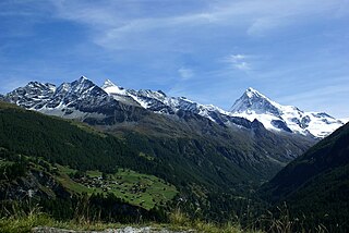
The Matterhorn is a mountain of the Alps, straddling the main watershed and border between Switzerland and Italy. It is a large, near-symmetric pyramidal peak in the extended Monte Rosa area of the Pennine Alps, whose summit is 4,478 metres (14,692 ft) high, making it one of the highest summits in the Alps and Europe. The four steep faces, rising above the surrounding glaciers, face the four compass points and are split by the Hörnli, Furggen, Leone/Lion, and Zmutt ridges. The mountain overlooks the Swiss town of Zermatt, in the canton of Valais, to the northeast; and the Italian town of Breuil-Cervinia in the Aosta Valley to the south. Just east of the Matterhorn is Theodul Pass, the main passage between the two valleys on its north and south sides, which has been a trade route since the Roman Era.

The Haute Route is the name given to a route undertaken on foot or by ski touring between the Mont Blanc in Chamonix, France, and the Matterhorn, in Zermatt, Switzerland.

The Grünhorn is a mountain in the Bernese Alps range of the Swiss Alps. It is located on the ridge between the two largest glaciers of the Alps: the Aletsch Glacier to the west and the Fiescher Glacier to the east. To the south lies the Gross Wannenhorn and, to the north, the Gross Fiescherhorn.

The Grimsel Pass is a mountain pass in Switzerland, crossing the Bernese Alps at an elevation of 2,164 metres (7,100 ft). The pass connects the Haslital, the upper valley of the river Aare, with the upper valley of the Rhône. In so doing, and as the Aare is a tributary of the Rhine, the pass crosses the continental divide between the North Sea and the Mediterranean Sea.

Arolla is a village in the municipality of Evolène in the Swiss canton of Valais. It is situated at the end of the Val d'Hérens, south of the cantonal capital, Sion.
Val d'Hérens is an alpine valley in the Valais canton of Switzerland. It was formed by the Hérens glacier, which retreated at the end of the last ice age. It is now the valley of the Borgne river, a tributary of the Rhone

Mont Collon is a mountain of the Swiss Pennine Alps in the canton of Valais. Its glaciated north face dominates the view south from the village of Arolla.

Adolphus Warburton Moore (1841–1887) was a British civil servant and mountaineer.

The Weisshorn is a major peak of Switzerland and the Alps, culminating at 4,506 metres above sea level. It is part of the Pennine Alps and is located between the valleys of Anniviers and Zermatt in the canton of Valais. In the latter valley, the Weisshorn is one of the many 4000ers surrounding Zermatt, with Monte Rosa and the Matterhorn.
Horace Walker (1838–1908) was an English mountaineer who made many notable first ascents, including Mount Elbrus and the Grandes Jorasses.

The Aiguilles Rouges d'Arolla are a multi-summited mountain of the Swiss Pennine Alps, located west of Arolla in the canton of Valais. The main summit has an elevation of 3,646 metres above sea level.

La Cassorte is a mountain of the Swiss Pennine Alps, located west of Arolla in the canton of Valais. It lies on the range between the Lac des Dix and the Val d'Arolla, south of the Aiguilles Rouges d'Arolla.

The Patrouille des Glaciers (PDG) is a ski mountaineering race organised every two years by the Swiss Armed Forces, in which military and civilian teams compete. It takes place once every two years at the end of April, in the south part of the canton of Valais below the summits of the Pennine Alps.

The Vignettes Hut is an alpine hut, located south of Arolla in the Swiss canton of Valais. It lies at a height of 3,160 metres above sea level, at the foot of the Pigne d'Arolla and near the Col de Chermotane in the Pennine Alps. All accesses to the hut involve glacier crossing.
Jakob Anderegg was a Swiss mountain guide and the first ascensionist of many prominent mountains in the western Alps during the golden and silver ages of alpinism. Jakob Anderegg made the first ascent of the following peaks or routes:
The Col de Chermotane is an Alpine pass located in the Swiss canton of Valais. With an elevation of 3,037 metres above sea level, the Col de Chermotane is the lowest pass between the valleys of Bagnes and Hérens. The pass lies a few kilometres north of the main chain of the Alps and is covered by the Otemma Glacier. It connects Chanrion to Arolla, both in the upper part of their valley.
The Pigne de la Lé is a mountain of the Swiss Pennine Alps, located south of Zinal in the canton of Valais. It lies north of the Grand Cornier, on the range between the Moiry Glacier and the valley of Zinal.

La Serpentine is a mountain of the Swiss Pennine Alps, located south of Arolla in the canton of Valais. It lies west of the Pigne d'Arolla, on the range between the valley of Bagnes and the valley of Arolla.

The Dix Hut is a mountain hut of the Swiss Alpine Club, located south of Hérémence in the canton of Valais. The hut lies above the Cheilon Glacier, at a height of 2,928 metres above sea level, approximately halfway between the Lac des Dix and the Mont Blanc de Cheilon.

The Annot derailment occurred on 8 February 2014 when a train travelling from Nice to Digne-les-Bains on the Chemins de Fer de Provence was hit by a rock which fell down a mountain side. Both vehicles of the train were derailed, killing two people and injuring 20 others.


