Seville is the capital and largest city of the Spanish autonomous community of Andalusia and the province of Seville. It is situated on the lower reaches of the River Guadalquivir, in the southwest of the Iberian Peninsula.

The Guadalquivir is the fifth-longest river in the Iberian Peninsula and the second-longest river with its entire length in Spain. The Guadalquivir is the only major navigable river in Spain. Currently it is navigable from the Gulf of Cádiz to Seville, but in Roman times it was navigable to Córdoba.
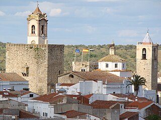
Azuaga is a town located in the province of Badajoz in southern Extremadura, bordering the Andalusian provinces of Seville and Córdoba in Spain. Azuga is 140 km from Badajoz, 125 km from Córdoba, and 140 km from Seville, in the foothills of Sierra Morena in the frontier region of Campiña Sur.

Pila, officially the Municipality of Pila, is a 3rd class municipality in the province of Laguna, Philippines. According to the 2020 census, it has a population of 54,613 people.

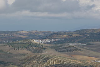
Olvera is a town in the province of Cádiz, Andalusia, Spain. According to the 2005 census, the city has a population of 8,585 inhabitants.

Sierro is a municipality of Almería province, in the autonomous community of Andalusia, Spain, It is located in the valley of the River Sierro in the 'Comarca del Mármol', county of the marble. The name 'Sierro' seems to come from the Latin 'serra' meaning mountain range.

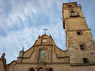
Santa Olalla del Cala is a large village within the Autonomous region of Andalucia in southern Spain. The village is also a municipality located in the province of Huelva. the village is situated 1.1 miles (1.8 km) west of the A66-E803 motorway which runs from Sevilla to Salamanca. The village is 43.7 miles (70.3 km) north of the city of Sevilla and 40.9 miles (65.8 km) south of the town of Zafra. The village is 447.5 kilometres (278.1 mi) from the Spanish capital of Madrid and takes approximately 6 hours to travel from there by taxi. The nearest airport is Sevilla Airport which is 52.0 miles (83.7 km) to the south of the village. The nearest railway station is at Llerena which is 34.6 miles (55.7 km) north east of the village.

Tutazá or Tutasá, is a town and municipality in the Colombian Department of Boyacá, part of the Tundama Province, a subregion of Boyacá. Tutazá borders the municipalities Belén, Paz de Río, Sativasur and Sativanorte of the department of Boyacá and Onzaga and Coromoro of the department of Santander.
Alameda is a town and municipality in the province of Málaga, part of the autonomous community of Andalusia in southern Spain. The municipality is situated approximately 85 km from the city of Málaga. It has a population of approximately 5,000 and the natives are called Alamedanos or Lametanos. It takes its name from the stream Álamos, which crosses the municipality. The Bandito "El Tempranillo" is buried here.
Almargen is a town and municipality in the province of Málaga, part of the autonomous community of Andalusia in southern Spain. The municipality is situated approximately 105 kilometers from the capital, Málaga. It is 43.7 km from Ronda and 48.2 km from Antequera. It has a population of approximately 2,100 residents. The natives are called Almargeños.

Gines is a municipality in the south-west Spain, in the province of Seville, Andalusia. It is part of the metropolitan area of Seville. Gines has a population of 13,529 inhabitants as of 2021 and an area of 2.9 km2 (1.1 sq mi).
Cabeza la Vaca is a municipality located in the province of Badajoz, Extremadura, Spain. The economy is based on agriculture. The surroundings have thousands of evergreen oaks, olive trees, pine trees and leafy scrubland.
Fregenal de la Sierra is a municipality located in the province of Badajoz, Extremadura, Spain.
Torrijo del Campo is a municipality located in the province of Teruel, Aragon, Spain. According to the 2018 census (INE), the municipality has a population of 447 inhabitants.

Abánades is a municipality located in the province of Guadalajara, Castile-La Mancha, Spain. According to the 2010 census (INE), the municipality had a population of 75 inhabitants.

Atlacomulco is one of 125 municipalities in the State of Mexico located in the northwest of the State of Mexico in central Mexico, 63 kilometres (39 mi) from the state capital of Toluca. The municipal seat is the city of Atlacomulco de Fabela. The name is derived from the Nahuatl phrase "atlacomulli" which means "where there are wells." The city, with a population of 109,384 is surrounded by rural area in which 75% of the rest of the municipality lives. The municipality has a sizable percentage of indigenous language speakers, mostly Mazahua. The Mazahua name for the area is Embaró, which means "colored rock." Agriculture is still the main economic activity, but the development of a number of industrial parks, such as Atlacomulco 2000, which allowed the seat to reach city statues by 1987. Atlacomulco is also the origin of a political organization called the "Atlacomulco Group" made up of powerful political figures who deny its existence.

Maçanet de Cabrenys is a municipality in the comarca of Alt Empordà, Girona, Catalonia, Spain. It also belongs to the subcomarca of Alta Garrotxa. It includes the villages of Arnera, Les Creus, Les Mines, Les Salines, Tapis, Els Vilars, and Oliveda. It is situated at the foot of the Eastern Pyrenees, with the Rivers Arnera and Frausa. It has numerous springs, which makes it attractive for tourism, the largest source of revenue, together with dryland farming and animal husbandry. It has a water bottling facility.

Calimaya is a town and municipality located just south of Toluca, the capital of the State of Mexico in central Mexico. The settlement was probably established around 800 BCE, when the city of Teotenango was in existence. It remained an important town through the colonial period, part of the vast lands held by a family which came to be known as the Counts of Calimaya. The town is home to one of the oldest examples of an open chapel in the State of Mexico. Today, the municipality is still mostly agricultural but there has been a rapid construction of housing divisions, changing parts of it from rural to suburban.

The Romería de El Rocío is a procession/pilgrimage on the second day of Pentecost to the Hermitage of El Rocío in the countryside of Almonte, Province of Huelva, Andalucia, Spain, in honor of the Virgin of El Rocío. In recent years the Romería has brought together roughly a million pilgrims each year.
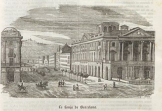
Llotja ; in Aragonese: loncha; in Spanish: lonja; is a Catalan term for important buildings used for commercial purpose during the Middle Ages and Early Modern Ages.