
The Pilbara freshwater ecoregion is a freshwater ecoregion in Australia. It includes several river basins in semi-arid northwestern Western Australia.
The Pilbara freshwater ecoregion is a freshwater ecoregion in Australia. It includes several river basins in semi-arid northwestern Western Australia.
The ecoregion includes, from south to north, the drainages of the Greenough, Murchison, Gascoyne, Ashburton, Fortescue, and De Grey rivers. [1] These rivers drain Western Australia's Pilbara and Gascoyne regions.
The climate of the ecoregion is tropical and semi-arid. Most of the rivers are intermittent (or ephemeral). The ecoregion has rugged terrain, underlain by ancient Precambrian blocks. Most of the ecoregion is over 200 metres in elevation, and the highest elevation is Mount Meharry at 1,253 metres elevation. Many of the rivers have carved deep canyons as they drain towards the Indian Ocean. During extended dry periods the rivers are reduced to shallow pools in protected canyons. [1]
The ecoregion adjoins the Great Sandy Desert to the north and east. It adjoins Southwestern Australia to the south, which has a more temperate and moist climate, with more year-round rivers.
There are extensive cave systems on the North West Cape, with subterranean brackish water habitats hosting unique aquatic communities. [1]
The ecoregion corresponds to the Indian Ocean drainage division and mostly corresponds to Pilbara–Gascoyne Level 1 drainage basin as defined in Australia's National Catchment Boundaries (NCB) system, although Pilbara–Gascoyne excludes the De Grey River.
The fish fauna includes both species widespread through Australia and species endemic to the ecoregion. 20 fish species are native to the ecoregion, of which 5, or 25%, are endemic. Widespread species include the bony bream (Nematalosa erebi), Hyrtl's catfish (Neosilurus hyrtlii), banded grunter ( Amniataba percoides ), and spangled perch (Leiopotherapon unicolor). [1]
Endemic freshwater species include the Murchison River hardyhead ( Craterocephalus cuneiceps ) and golden gudgeon ( Hypseleotris aurea ), which are found in the rivers from the Gascoyne south, and the Fortescue grunter (Leiopotherapon aheneus), which is found in the Fortescue and Ashburton rivers. [1]
The blind gudgeon ( Milyeringa veritas ) and blind cave eel (Ophisternon candidum) are endemic to brackish-water caves on the North West Cape. [1]
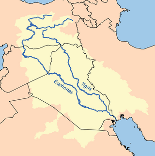
The Tigris–Euphrates river system is a large river system in Western Asia that discharges into the Persian Gulf. Its principal rivers are the Tigris and Euphrates, along with smaller tributaries.
The Pilbara is a large, dry, thinly populated region in the north of Western Australia. It is known for its Aboriginal peoples; its ancient landscapes; the red earth; and its vast mineral deposits, in particular iron ore. It is also a global biodiversity hotspot for subterranean fauna.

Southwest Australia is a biogeographic region in Western Australia. It includes the Mediterranean-climate area of southwestern Australia, which is home to a diverse and distinctive flora and fauna.

The Avon Wheatbelt is a bioregion in Western Australia. It has an area of 9,517,104 hectares. It is considered part of the larger Southwest Australia savanna ecoregion.

The North West, North West Coast, North Western Australia and North West Australia, are usually informal names for the northern regions of the State of Western Australia. However, some conceptions of "North West Australia" have included adjoining parts of the Northern Territory (NT) – or even the entire NT.
The Fortescue grunter is a species of freshwater ray-finned fish, a grunter from the family Terapontidae. It is endemic to rivers in Western Australia.

Leiopotherapon is a genus of fish in the family Terapontidae, the grunters. Three species are endemic to Australia, while L. plumbeus is from the Philippines. They are mainly found in fresh water, although H. unicolor also occurs in desert lakes with higher salinity.

The Permanent Maghreb of World Wide Fund for Nature is a freshwater ecoregion of North Africa.
Western Australia has the longest coastline of any state or territory in Australia, at 10,194 km or 12,889 km. It is a significant portion of the coastline of Australia, which is 35,877 km.

The Northern Basin and Range ecoregion is a Level III ecoregion designated by the United States Environmental Protection Agency (EPA) in the U.S. states of Oregon, Idaho, Nevada, Utah, and California. It contains dissected lava plains, rolling hills, alluvial fans, valleys, and scattered mountain ranges in the northern part of the Great Basin. Although arid, the ecoregion is higher and cooler than the Snake River Plain to the north and has more available moisture and a cooler climate than the Central Basin and Range to the south. Its southern boundary is determined by the highest shoreline of Pleistocene Lake Bonneville, which once inundated the Central Basin and Range. The western part of the region is internally drained; its eastern stream network drains to the Snake River system.

Southwestern Sri Lanka rivers and streams is a freshwater ecoregion in Sri Lanka. The ecoregion is listed in Global 200, a list of ecoregions compiled by the World Wide Fund for Nature for conservation priorities. The extensive network of rivers and streams of Sri Lanka drains a total of 103 distinct natural river basins. Several waterfall habitats have been formed as a result of rivers and streams flowing through high and mid elevation areas. The ecoregion spreads over 15,500 km2 in the wet zone of the southwestern part of Sri Lanka. More than a quarter of the freshwater fishes that have been discovered in Southwestern Sri Lanka rivers and streams are endemic. Nine endemic genera of freshwater fishes of Western Ghats and Sri Lanka hotspot Malpulutta are found only in Sri Lanka. Studies suggest that the number of species still to be discovered is quite high. Until recently wetlands in Sri Lanka were used for drainage, construction sites and land fills.

The Naracoorte woodlands is an ecoregion in southern Australia. It covers the Naracoorte coastal plain in southeastern South Australia and southwestern Victoria. It is coterminous with the Naracoorte Coastal Plain IBRA region. Only 10% of the ecoregion's area still has its original vegetation; most has been converted to agriculture and pasture.
The 1900 Western Australian floods were a series of flooding events from March to May 1900 that affected large areas of Western Australia, primarily in the Pilbara and Gascoyne regions, though it extended to cover most of the state except the more humid Kimberley and South West regions.

Lake Yliki is a large natural lake of Boeotia, central Greece. Situated 8 km north of Thebes at 78 m elevation, it has been an important source of drinking water for the Athens agglomeration since 1958. It is surrounded by low mountains, which separate it from the drained Lake Copais.

The Nimba Range forms part of the southern extent of the Guinea Highlands. The highest peak is Mount Richard-Molard on the border of Côte d'Ivoire and Guinea, at 1,752 m (5,748 ft). "Mount Nimba" may refer either to Mount Richard-Molard or to the entire range. Other peaks include Grand Rochers at 1,694 m (5,558 ft), Mont Sempéré at 1,682 m (5,518 ft), Mont Piérré Richaud at 1,670 m (5,480 ft), Mont Tô at 1,675 m (5,495 ft), and Mont LeClerc 1,577 m (5,174 ft), all of them are located in Guinea. Mount Nimba Strict Nature Reserve of Guinea and Côte d'Ivoire covers significant portions of the Nimba Range.
Eremophila accrescens is a plant in the figwort family, Scrophulariaceae and is endemic to Western Australia where it usually grows in rocky places or near drainage channels. It is an erect shrub with greyish, slightly furry, variably-shaped leaves and white to pale blue or purple petals.

Acacia palustris, commonly known as needlewood, is a tree or shrub belonging to the genus Acacia and the subgenus Juliflorae that is native to an arid area of western Australia

Acacia marramamba, commonly known as marramamba, is a shrub or tree belonging to the genus Acacia and the subgenus Phyllodineae that is endemic to arid parts of western Australia.

The Pilbara shrublands is a deserts and xeric shrublands ecoregion in Western Australia. It is coterminous with the Pilbara IBRA region. For other definitions and uses of "Pilbara region" see Pilbara.