Related Research Articles

Jaunpur is a city and a municipal board in Jaunpur district in the Indian state of Uttar Pradesh. It is located 228 km southeast of state capital Lucknow. Demographically, Jaunpur resembles the rest of the Purvanchal area in which it is located.
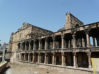
Jaunpur district is a district in the Varanasi Division of the Indian state of Uttar Pradesh. The district headquarters is the city of Jaunpur which is situated on the banks of the Gomti River. It is located 228 km southeast of the state capital Lucknow. 65 km northwest of Varanasi and 732 km southeast of New Delhi. The district has two Lok Sabha seats and nine Vidhan Sabha seats. According to the 2011 census, Jaunpur has a gender ratio of 1,018 females to 1,000 males, the highest in Uttar Pradesh. The main languages spoken in the district is Hindi and Urdu.
Bilariaganj is the second largest city and a Nagar Palika Parishad in Azamgarh division after its capital city Azamgarh in the state of Uttar Pradesh, India.

Ghosi comes under Mau district of Uttar Pradesh State. It belongs to Azamgarh Division. It is located 24 km towards North from District headquarters Mau. It is a Block headquarter.
Kerakat or Kirakat is a town and nagar panchayat in Jaunpur district of the Indian state of Uttar Pradesh with a population of approximately 13,500. It is situated near the Gomati River, which helps the land around the town stay very fertile. Kerakat or Kirakat forms a part of Varanasi Division. It is located 30 km east of the city of Jaunpur and 279 km from Lucknow, the capital of Uttar Pradesh.

Hanswar is a village in the Ambedkar Nagar district of Uttar Pradesh, India, located east of Tanda. Demographically, Hanswar resembles the rest of the Purvanchal area in which it is located.

Janghai is a market and Gram Panchayat in the district of Prayagraj, in the Indian state of Uttar Pradesh. It is located 226 km kilometres southeast of the state capital, Lucknow, and 24 kilometres from Handia Tehsil. As of 2022, Janghai's population was about 29,000.
Zabran Pur, also Zabranpur or Zabaranpur, otherwise Jabaranpur, Jabranpur or Jabran Pur, is a small village in Saidpur block, Ghazipur district, Varanasi division, Uttar Pradesh, India.
Gariaon is a village in Jaunpur district in the Indian state of Uttar Pradesh. It is also known as Gariaon Bazar. Gariaon is located 6 km kilometres north-west of Janghai Junction Railway Station and 13 km east of Mungra Badshahpur.
Pattinarendrapur is a village in Khutahan Block, Shahganj Tehsil, Jaunpur District, Varanasi division, Uttar Pradesh, India. Its Postal Code is 223102.
Usraon (Mariyahu) is a town and nagar panchayat in Jaunpur district in the Indian state of Uttar Pradesh. It is one of the six tahsils of Jaunpur District; the others are Jaunpur City, Shahganj, Machalishahar, Badlapur and Kerakat.
Walidpur is a village in Mau district in the Indian state of Uttar Pradesh.
Suhwal is a village in the Kamsar region of Ghazipur district under Reotipur block. It is situated on Ghazipur to Buxar Road 8 km (5 mi) from Ghazipur City. Its population is 10,814. The Village is quite old. It has its own local administration under the Panchayati Raj system, with Gram Pradhan as head of local administration. There are two Government Secondary Schools, three Government Primary Schools and some privately run Schools. There is a small permanent Market in the western side of the Village and also a weekly Market. Suhwal is a center of Shopping and Primary Education for many other small villages situated on its fringe.

Baramadpur is a village in Akhand Nagar block of Kadipur tehsil in Sultanpur district of Uttar Pradesh, India. As of 2011, it has a population of 3,251 people, in 442 households. It has one primary school and one primary health centre and it hosts both a regular market and a weekly haat. It is part of the nyaya panchayat of Sajampur.
Teunga is a village in Phulpur tehsil in Azamgarh district of Uttar Pradesh state, India. It comes under Teunga Panchayath. It belongs to Azamgarh division. It is located 36 km west from district headquarters Azamgarh, 2 km from Phulpur and 243 km from state capital Lucknow.
Meerganj is a village in Jaunpur district in the Indian state of Uttar Pradesh. Meerganj is located 6 km kilometres north-east of Janghai Junction railway station and 1 km west of Jarauna railway station.
Jaunpur City railway station is one of the railway stations in Jaunpur district, Uttar Pradesh, India. It is situated on the southwest side of the city about 5 km from Jaunpur Junction railway station. This station is under the administration of Northern Railway zone's Lucknow division and Varanasi–Jaunpur–Sultanpur–Lucknow line. It is the cleanest railway station in whole city compared to Jaunpur Junction, Zafarabad Junction, Shahganj Junction and Janghai Junction.
Bhadon is a village and Gram Panchayat located in Martinganj tehsil of the Azamgarh District in the Indian state of Uttar Pradesh, near the border with Jaunpur District. It is 37.7 kilometres (23.4 mi) north-east of the district headquarters in Azamgarh and 229.9 kilometres (142.9 mi) from the state capital of Lucknow.

Bisauri is a village of the Jaunpur district, Uttar Pradesh, Northern India. Bisauri's Postal Index Number is 222129 and its post office is at Patrahi. The village is also a Gram Panchayat, comprising itself and the village of Tiwaripur.
Patrahi is a small village/market in Dobhi Block in Jaunpur district, Uttar Pradesh State, India. It comes under Patarahi Panchayath. It belongs to Varanasi Division. It is located 49 km (30 mi) towards East from District headquarters Jaunpur and 288 km (179 mi) from the state capital Lucknow. The nearest town is Kerakat, while and Varanasi and Jaunpur are the nearest cities.
References
- ↑ http://eci.nic.in/archive/se2002/pollupd/ac/states/s24/acnstcand241.htm Election Commission data, retrieved on 11 August 2010
25°58′N82°33′E / 25.967°N 82.550°E
| | This Jaunpur district location article is a stub. You can help Wikipedia by expanding it. |