Bhind is a city in the Indian state of Madhya Pradesh. It is the headquarters of the Bhind district.

Lakhisarai town is the administrative headquarters of Lakhisarai district in the Indian state of Bihar. The town has a population of 99,979. it is situated about 45 km west of Munger.
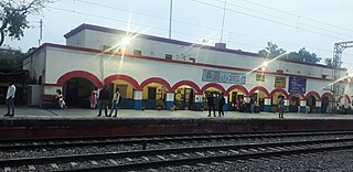
Amroha is a city in the state of Uttar Pradesh in India. It is located north-west of Moradabad, near the Ganga River. It is the administrative headquarters of the Amroha district.

Guna is a city and a municipality in Guna district in the Indian state of Madhya Pradesh. It is the administrative headquarters of Guna District and is located on the banks of Parbati river.
Farrukhabad is a city in the Indian state of Uttar Pradesh. It is the administrative headquarters of the Farrukhabad tehsil. The city is on the banks of river Ganges and is 295 kilometres (183 mi) from the national capital Delhi and 210 kilometres (130 mi) from the state capital Lucknow.
Barahiya is a town and nagar parishad in Lakhisarai district in the Indian state of Bihar. It has a total population of 43,032. It lies on the southern bank of the river Ganges, about 116.8 km east of Patna

Deoria is a city in the state of Uttar Pradesh, India. It is one of five tehsils of the Deoria district. Deoria is located 45 km east of Gorakhpur and about 317 km from the state capital Lucknow. It shares its eastern border with Bihar.
Dhanuha is a census town in Jaunpur district in the state of Uttar Pradesh, India.

Khatima is a city and a municipal board in Udham Singh Nagar district in the Indian state of Uttarakhand.
Mhowgaon is a Nagar Panchayat under Sub Division Dr. Ambedkar Nagar (Mhow) in Indore district in the Indian state of Madhya Pradesh. The total geographical area of Mhowgaon nagar panchayat is 13.5 km2 and it is the smallest city by area in the sub district. The population density of the city is 2309 persons per km2. Mhowgaon is divided into 15 wards for which elections are held every 5 years. Among them, Mhowgaon Ward No. 2 is the most populous ward with a population of 3440 and Mhowgaon Ward No. 15 is the least populous ward with a population of 957. Mhowgaon Nagar Panchayat has total administration over 6,373 houses to which it supplies basic amenities like water and sewerage. It is also authorized to build roads within Nagar Panchayat limits and impose taxes on properties coming under its jurisdiction.

Musafirkhana is a town and tehsil in Amethi district in Indian state of Uttar Pradesh. The word "Musafirkhana" means "Sarai," or "Dharamshala". Musafirkhana is located 32 km northwest of Amethi, 20 km from Jagdishpur. Gauriganj and Amethi are accessible from Musafirkhana via roadways; the nearest railway station is the Musafirkhana railway station on the Lucknow–Varanasi rail route via Sultanpur, and the nearest airport is the Amausi airport. It is surrounded by more than 100 villages. The town is between 26.37° north latitude and 81.8° east longitude at a height of 102 metres (434 feet) above mean sea level.
Nainana Jat is a census town in Agra district in the Indian state of Uttar Pradesh.
Nasrullaganj, also known as Bherunda, is a nagar panchayat in Sehore district in the Indian state of Madhya Pradesh. The nearest airport is in Bhopal.
Pachperwa is a town and a nagar panchayat in Balrampur district in the Indian state of Uttar Pradesh. Pachperwa is situated 54 km (34 mi) from district headquarters Balrampur and 200 km (120 mi) from state capital Lucknow. The National Highway 730 connected the town to district headquarters as well as other cities.
Pinahat is a town and a nagar panchayat in Agra district in the Indian state of Uttar Pradesh and situated on the Bank of Chambal River. It is about 55 km from Agra. The distance between Pinahat and Chambal is only 2 km.
Sarai Mir is a town and a nagar panchayat in Azamgarh district in the Indian state of Uttar Pradesh.
Jafarabad is a town and nagar panchayat in Jaunpur district in the Indian state of Uttar Pradesh.

Nawabganj is a town and nagar panchayat in Hasanganj tehsil of Unnao district, Uttar Pradesh, India. It is located northeast of Unnao on the Lucknow-Kanpur road, near the Ajgain railway station. Founded in 1842 and first officially classified as a town for the 1981 census, Nawabganj once served as the seat of a tehsil under the Nawabs of Awadh and is today the headquarters of a community development block containing 124 villages.
Punjab is home to 2.3% of India's population; with a density of 551 persons per km2. According to the provisional results of the 2011 national census, Punjab has a population of 27,743,338, making it the 16th most populated state in India. Of which male and female are 14,639,465 and 13,103,873 respectively. 32% of Punjab's population consists of Dalits. In the state, the rate of population growth is 13.9% (2011), lower than national average. Out of total population, 37.5% people live in urban regions. The total figure of population living in urban areas is 10,399,146 of which 5,545,989 are males and while remaining 4,853,157 are females. The urban population in the last 10 years has increased by 37.5%. According to the 2011 Census of India, Punjab, India has a population of around 27.7 million.
Atariya is a village in the Hardoi district of the Indian state of Uttar Pradesh. Atariya village is situated 48 km away from district headquarter Hardoi.

