Related Research Articles

Bareilly division is an administrative geographical unit of Uttar Pradesh state of India. Bareilly is the administrative headquarters of the division. Part of the Rohilkhand region, Bareilly division has three major cities in west Uttar Pradesh - Bareilly, Badaun, Pilibhit and Shahjahanpur.
The Dhasan River is a right bank tributary of the Betwa River. The river originates in Begumganj tehsil of Raisen district in Madhya Pradesh state in central India. The river forms the southeastern boundary of the Lalitpur District of Uttar Pradesh state. Total length of the river is 365 km, out of which 240 km lies in Madhya Pradesh, 54 km common boundary between Madhya Pradesh and Uttar Pradesh and 71 km in Uttar Pradesh. The river was known as the Dasharna in ancient period. The Lehchura Dam is built on this river at 2 km from Harpalpur railway station. Residents of nearby villages regard this river as a holy river.

Ballia district is one of the districts of Uttar Pradesh, India. Ballia district is a part of Azamgarh division situated in the east of Uttar Pradesh. The main economic activity is agriculture. Ballia City is the district headquarters and commercial market of this district. There are six tehsils in this district: Ballia, Bansdih, Rasra, Bairia, Sikandarpur and Belthara. Rasra is the second major commercial area of the district, having a government sugar mill and a cotton weaving industry. Though Ballia's core occupation is agriculture there are some additional small industries. Maniar is known for its bindi industry and is a major supplier.

Etawah district is one of the districts in the western portion of Uttar Pradesh state of India. Etawah town is the district headquarters. The district covers an area of 2311 km2. It has a population of 1,581,810.
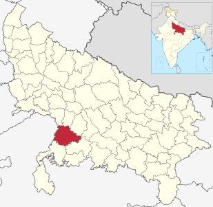
Jalaun district is a district of Uttar Pradesh, India. The district is named after the town of Jalaun, which was the former headquarters of a Maratha governor, but the administrative headquarters of the district is at Orai. Other large towns in the district are Konch, Kalpi, and Madhogarh.

Shahjahanpur district is one of the historical districts of Uttar Pradesh in the republic of India. It is a part of Bareilly division which is situated in south-east of Rohilkhand division. It was established in 1813 by the British Government. Previously it was a part of district Bareilly. Geographically the main town is Shahjahanpur city which is its headquarters. Its Tehsils are: Powayan, Tilhar, Jalalabad,Kalan, and Sadar.

Shravasti district is one of the districts of the Uttar Pradesh state of India, with Bhinga town as its district headquarters. Shravasti district is a part of Devipatan Division. According to Government of India, it is one of the minority concentrated districts in India on the basis of the 2001 census data on population, socio-economic indicators and basic amenities indicators.

Kannauj district is an administrative district of Uttar Pradesh state in northern India, along the river Ganges. The historic town of Kannauj, northwest of Kanpur, is the administrative center. The district was carved out of the Farrukhabad district on 18 September 1997. The native dialect of this district is Kannauji.

Hardoi district is a district situated in the center of Uttar Pradesh, India, and Hardoi town is the district headquarters.

Lucknow district is a district located in the Uttar Pradesh state in northern India. The city of Lucknow is the district headquarters and the district is part of Lucknow Division. It also is the capital of Uttar Pradesh.

Barkhera is a town and a nagar panchayat in Pilibhit district in the Indian state of Uttar Pradesh.
Khudaganj is a town and a nagar panchayat in Shahjahanpur district in the Indian state of Uttar Pradesh.

Kunda is a town and a Tahsil in Pratapgarh district in the Indian state of Uttar Pradesh.
Janakpatti is a village in Varanasi district, Uttar Pradesh, India. The village has population of about 450 and is located close to the Varanasi–Jaunpur border.
Girdharpur( गिरधरपुर, گردھرپر ) is a village in Bareilly district of the Indian state of Uttar Pradesh. It is 3 kilometers away from State Highway 37 and lies within the coordinates 28°42'51.60"N & 79°27'46"E.
Aryapur Khera is the village. Mainpuri city is an administrative headquarters of this village. Mainpuri is located to the north-east of Agra.
Tharakki Patti is a village in the Northern Indian state of Uttar Pradesh. It is located in the Tarab Ganj taluk of Gonda district. The river Kutila is around 1 km from the main village.

Baoni State was a princely state in India during the British Raj. It was a small sanad state, the only Muslim-ruled one in Bundelkhand Agency. Its ruler was granted the right to an 11 gun salute. The Baoni Royal Family claim to be descendants of the Asaf Jahi dynasty of Hyderabad, tracing its origins to Abu Bakr, the First Islamic Caliph.
Majhupur is a village located in Kannauj district in the Indian state of Uttar Pradesh. The village was founded by Manju Singh Sikarwar.
Kandharapur is a village in Azamgarh District, Uttar Pradesh, India.
References
- ↑ Food and Civil Supplies Department, Uttar Pradesh Archived 11 July 2015 at the Wayback Machine
| This Jaunpur district location article is a stub. You can help Wikipedia by expanding it. |