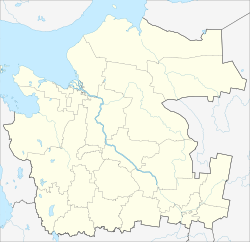
Kholmogorsky District is an administrative district (raion), one of the twenty-one in Arkhangelsk Oblast, Russia. Municipally, it is incorporated as Kholmogorsky Municipal District. It is located in the center of the oblast and borders with Pinezhsky District in the east, Vinogradovsky District in the southeast, the territory of the town of oblast significance of Mirny in the south, Plesetsky District in the southwest, and with Primorsky District in the northwest. The area of the district is 16,827 square kilometers (6,497 sq mi). Its administrative center is the rural locality of Kholmogory. District's population: 25,061 (2010 Census); 30,797 (2002 Census); 35,891 (1989 Census). The population of Kholmogory accounts for 16.6% of the district's total population.
Konoshsky District is an administrative district (raion), one of the twenty-one in Arkhangelsk Oblast, Russia. As a municipal division, it is incorporated as Konoshsky Municipal District. It is located in the southwest of the oblast and borders with Nyandomsky District in the north, Velsky District in the east, Verkhovazhsky, Vozhegodsky, and Kirillovsky Districts of Vologda Oblast in the south, and with Kargopolsky District in the west. The area of the district is 8,500 square kilometers (3,300 sq mi). Its administrative center is the urban locality of Konosha. Population: 26,106 (2010 Census); 31,067 (2002 Census); 42,136 (1989 Census). The population of Konosha accounts for 47.6% of the district's total population.
Lensky District is an administrative district (raion), one of the twenty-one in Arkhangelsk Oblast, Russia. As a municipal division, it is incorporated as Lensky Municipal District. It is located in the southeast of the oblast and borders with Udorsky District of the Komi Republic in the north, Syktyvdinsky, Ust-Vymsky, and Sysolsky Districts, also of the Komi Republic, in the east, Vilegodsky District in the south, and with Kotlassky and Krasnoborsky Districts in the west. The area of the district is 10,700 square kilometers (4,100 sq mi). Its administrative center is the rural locality of Yarensk. Population: 13,362 (2010 Census); 16,071 (2002 Census); 20,488 (1989 Census). The population of Yarensk accounts for 27.4% of the district's total population.
Within the framework of administrative divisions, Arkhangelsk Oblast is divided into six cities and towns of oblast significance, twenty-one districts, and two island territories. Besides, Mirny is a town under the federal government management.

Leshukonsky District is an administrative district (raion), one of the twenty-one in Arkhangelsk Oblast, Russia. Municipally, it is incorporated as Leshukonsky Municipal District. It is located in the northeast of the oblast and borders with Mezensky District in the north, Ust-Tsilemsky District of the Komi Republic in the east, Udorsky District of the Komi Republic in the south, and with Pinezhsky District in the west. Its administrative center is the rural locality of Leshukonskoye. District's population: 7,979 (2010 Census); 10,708 (2002 Census); 15,488 (1989 Census). The population of Leshukonskoye accounts for 55.2% of the district's population.
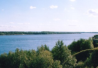
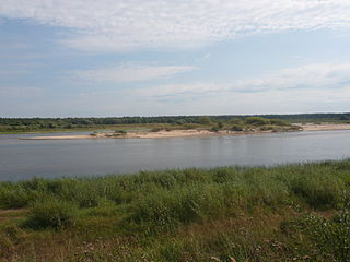
Bereznik, also known as Dvinskoy Bereznik, is an rural locality and the administrative center of Vinogradovsky District of Arkhangelsk Oblast, Russia, located on the left bank of the Northern Dvina River, 192 kilometers (119 mi) southeast of Kholmogorskaya railway station and 276 kilometers (171 mi) from Arkhangelsk. Within the framework of municipal divisions, it serves as the administrative center of Bereznikovskoye Urban Settlement, the only urban settlement in the district. Population: 6,018 (2010 Census); 6,464 (2002 Census); 7,006 (1989 Census); ~4,000 (1968).
Privodino is an urban locality in Kotlassky District of Arkhangelsk Oblast, Russia, located on the left bank of the Northern Dvina River 23 kilometers (14 mi) from Kotlas. Municipally, it is the administrative center of Privodinskoye Urban Settlement, one of the three urban settlements in the municipal district. Population: 3,161 (2010 Census); 3,264 (2002 Census); 3,154 (1989 Census).

Urdoma is an urban locality in Lensky District of Arkhangelsk Oblast, Russia, located on the Verkhnyaya Lupya River, a tributary of the Vychegda. Municipally, it is the administrative center of Urdomskoye Urban Settlement, the only urban settlement in the district. Population: 4,577 (2010 Census); 4,637 (2002 Census); 4,998 (1989 Census)..

Ustyansky District is an administrative district (raion), one of the twenty-one in Arkhangelsk Oblast, Russia. As a municipal division, it is incorporated as Ustyansky Municipal District. It is located in the south of the oblast and borders with Verkhnetoyemsky District in the northeast, Krasnoborsky and Kotlassky Districts in the east, Velikoustyugsky, Nyuksensky, Tarnogsky, and Verkhovazhsky Districts, all of Vologda Oblast, in the south, Velsky District in the west, and with Shenkursky District in the northwest. The area of the district is 10,700 square kilometers (4,100 sq mi). Its administrative center is the urban locality of Oktyabrsky. Population: 30,581 (2010 Census); 37,131 (2002 Census); 45,352 (1989 Census). The population of Oktyabrsky accounts for 30.4% of the district's total population.

Krasnoborsky District is an administrative district (raion), one of the twenty-one in Arkhangelsk Oblast, Russia. Municipally, it is incorporated as Krasnoborsky Municipal District. It is located in the southeast of the oblast and borders with Verkhnetoyemsky District in the north, Udorsky District of the Komi Republic in the northeast, Lensky District in the east, Kotlassky District in the south, and with Ustyansky District in the west. Its administrative center is the rural locality of Krasnoborsk. District's population: 13,815 (2010 Census); 17,144 (2002 Census); 20,491 (1989 Census). The population of Krasnoborsk accounts for 34.5% of the district's total population.
Verkhnetoyemsky District is an administrative district (raion), one of the twenty-one in Arkhangelsk Oblast, Russia. Municipally, it is incorporated as Verkhnetoyemsky Municipal District. It is located in the southeast of the oblast and borders with Pinezhsky District in the north, Udorsky District of the Komi Republic in the east, Krasnoborsky and Ustyansky Districts in the south, Shenkursky District in the west, and with Vinogradovsky District in the northwest. Its administrative center is the rural locality of Verkhnyaya Toyma. District's population: 17,060 (2010 Census); 22,630 (2002 Census); 27,989 (1989 Census). The population of Verkhnyaya Toyma accounts for 20.3% of the district's total population.
Shenkursky District is an administrative district (raion), one of the twenty-one in Arkhangelsk Oblast, Russia. As a municipal division, it is incorporated as Shenkursky Municipal District. It is located in the south of the oblast and borders with Vinogradovsky District in the north, Verkhnetoyemsky District in the east, Ustyansky District in the southeast, Velsky District in the south, Nyandomsky District in the west, and with Plesetsky District in the northwest. The area of the district is 11,298 square kilometers (4,362 sq mi). Its administrative center is the town of Shenkursk. Population: 15,196 (2010 Census); 18,680 (2002 Census); 22,597 (1989 Census). The population of Shenkursk accounts for 37.5% of the district's total population.

Nyandomsky District is an administrative district (raion), one of the twenty-one in Arkhangelsk Oblast, Russia. As a municipal division, it is incorporated as Nyandomsky Municipal District. It is located in the southwest of the oblast and borders with Plesetsky District in the north and west, Shenkursky District in the east, Velsky District in the southeast, Konoshsky District in the south, and with Kargopolsky District in the southwest. The area of the district is 8,100 square kilometers (3,100 sq mi). Its administrative center is the town of Nyandoma. Population: 30,244 (2010 Census); 33,465 (2002 Census); 40,601 (1989 Census). The population of Nyandoma accounts for 73.9% of the district's total population.

Vinogradovsky District is an administrative district (raion), one of the twenty-one in Arkhangelsk Oblast, Russia. As a municipal division, it is incorporated as Vinogradovsky Municipal District. It is located in the center of the oblast and borders with Pinezhsky District in the northeast, Verkhnetoyemsky District in the southeast, Shenkursky District in the south, Plesetsky District in the southwest, the town of oblast significance of Mirny in the west, and with Kholmogorsky District in the northwest. The area of the district is 12,600 square kilometers (4,900 sq mi). Its administrative center is the urban locality of Bereznik. Population: 16,753 (2010 Census); 20,862 (2002 Census); 24,834 (1989 Census). The population of Bereznik accounts for 35.9% of the district's total population.

Obozersky is an urban locality in Plesetsky District of Arkhangelsk Oblast, Russia, located on the upper Vaymuga River, a tributary of the Yemtsa River in the Northern Dvina basin. Obozersky lies 133 kilometers (83 mi) south of Arkhangelsk. The name of the settlement originates from Lake Obozero, located south of Obozersky. Military airfield Letneozyorsk is located 3 kilometers (1.9 mi) southeast of the settlement. Municipally, Obozersky is the administrative center of Obozerskoye Urban Settlement, one of the eight urban settlements in the district. Population: 3,620 (2010 Census); 3,725 (2002 Census); 5,837 (1989 Census)..

Samoded is a rural locality located in the north of Plesetsky District of Arkhangelsk Oblast, Russia, on both banks of the Vaymuga River, a tributary of the Yemtsa River. Within the framework of municipal divisions, it serves as the administrative center of Samodedskoye Rural Settlement, one of the thirteen rural settlements in the district. Population: 1,518 (2010 Census); 2,004 (2002 Census); 3,072 (1989 Census).
Pinezhsky District is an administrative district (raion), one of the twenty-one in Arkhangelsk Oblast, Russia. Municipally, it is incorporated as Pinezhsky Municipal District. It is located in the northeast of the oblast and borders with Mezensky District in the north, Leshukonsky District and Udorsky District of the Komi Republic in the east, Verkhnetoyemsky District in the south, Vinogradovsky District in the southwest, Kholmogorsky District in the west, and with Primorsky District in the northwest. Its administrative center is the rural locality of Karpogory. District's population: 26,978 (2010 Census); 33,516 (2002 Census); 40,486 (1989 Census). The population of Karpogory accounts for 16.5% of the district's total population.
Karpogory is a rural locality and the administrative center of Pinezhsky District, Arkhangelsk Oblast, Russia, located on the right bank of the Pinega River. It also serves as the administrative center of Karpogorsky Selsoviet, one of the seventeen selsoviets into which the district is administratively divided. Municipally, it is the administrative center of Karpogorskoye Rural Settlement. Population: 4,443 (2010 Census); 4,617 (2002 Census); 5,335 (1989 Census).

Mezensky District is an administrative district (raion), one of the twenty-one in Arkhangelsk Oblast, Russia. As a municipal division, it is incorporated as Mezensky Municipal District. It is located in the northeast of the oblast and borders with Nenets Autonomous Okrug in the northeast, Ust-Tsilemsky District of the Komi Republic in the east, Leshukonsky and Pinezhsky Districts in the south, and with Primorsky District in the southwest. From the north, the district borders the White Sea. The area of the district is 34,400 square kilometers (13,300 sq mi). Its administrative center is the town of Mezen. Population: 10,330 (2010 Census); 13,124 (2002 Census); 17,796 (1989 Census). The population of Mezen accounts for 34.6% of the total district's population.

Leshukonskoye is a rural locality and the administrative center of Leshukonsky District of Arkhangelsk Oblast, Russia, located on the left bank of the Vashka River. It also serves as the administrative center of Leshukonsky Selsoviet, one of the seven selsoviets into which the district is administratively divided. Municipally, it is the administrative center of Leshukonskoye Rural Settlement. Population: 4,406 (2010 Census); 5,003 (2002 Census); 6,199 (1989 Census).