Pinnacle Valley is the northwesternmost neighborhood of the city of Little Rock, Arkansas. The area is to the south of Pinnacle Mountain, one of the highest elevations in Pulaski County. Like Chenal Valley which borders the area on its south side, Pinnacle Valley is a fast-developing portion of Little Rock as the city continues to expand westward.
The neighborhood is anchored by Arkansas Highway 10 (which is officially signed as Cantrell Road on the portions that are inside Little Rock corporate limits), although most in the area refer to the path located west of an intersection with Interstate 430 simply as Highway 10. Minor developed areas including Pleasant Ridge and Walton Heights buffer Pinnacle Valley from the interstate on its eastern side. To the west and other directions lie unincorporated areas of Pulaski County.
Development of Pinnacle Valley's commercial corridor along Highway 10 has increased specifically since 2000, with new office complexes and retail centers still under construction by the spring of 2006. Juxtaposed with the new construction is a small number of existing homes from years prior to the area's annexation into Little Rock's city limits, including the formerly unincorporated community of Pankey.
The area, which includes the Little Maumelle River, was subject to a major flood when the Arkansas River crested at 29.71 feet (nearly seven feet above flood stage) on the early morning of June 5, 2019. This is the fourth highest recorded level. <US Army Corps of Engineers>
The Ranch, a western portion of the neighborhood that adjoins the highway to the north, is the site of small family home development and major employers including a customer service call center for AT&T Mobility (the wireless operations of AT&T Inc. formerly named Cingular Wireless) and headquarters for the craft-instruction guide publisher Leisure Arts, which has many products affiliated with the Time, Inc. subsidiary of Time Warner.
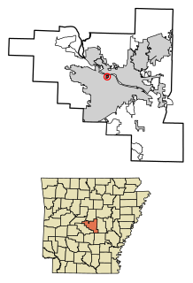
Pulaski County is located in the U.S. state of Arkansas with a population of 391,911, making it the most populous county in Arkansas. Its county seat is Little Rock, which is also Arkansas's capital and largest city. Pulaski County is Arkansas's fifth county, formed on December 15, 1818, alongside Clark and Hempstead Counties. The county is named for Casimir Pulaski, a Polish volunteer who saved George Washington's life during the American Revolutionary War. Pulaski County is included in the Little Rock–North Little Rock–Conway, AR Metropolitan Statistical Area which had 731,612 people in the 2015 census estimates. The Little Rock, North Little Rock Combined Statistical Area had 904,469 people in the 2015 census estimates.
Scott is an unincorporated community and census-designated place (CDP) in Lonoke and Pulaski counties in the central part of the U.S. state of Arkansas. The population was 72 at the 2010 census. It is part of the Little Rock–North Little Rock–Conway Metropolitan Statistical Area.
Cammack Village is a city in Pulaski County, Arkansas, United States. The population was 768 at the 2010 census. It is part of the Little Rock–North Little Rock–Conway metropolitan area.
McAlmont, also referred to as "Mac Side", is a census-designated place (CDP) in Pulaski County, Arkansas, United States. The population was 1,873 at the 2010 census. The community adjoins eastern North Little Rock, and is part of the Little Rock–North Little Rock–Conway Metropolitan Statistical Area.
North Little Rock is a city in Pulaski County, Arkansas, United States, across the Arkansas River from Little Rock in the central part of the state. The population was 62,304 at the 2010 census. In 2019 the estimated population was 65,903, making it the seventh-most populous city in the state. North Little Rock, along with Little Rock and Conway, anchors the six-county Little Rock–North Little Rock–Conway Metropolitan Statistical Area, which is further included in the Little Rock-North Little Rock Combined Statistical Area with 902,443 residents.
Central Arkansas, also known as the Little Rock metro, designated by the United States Office of Management and Budget as the Little Rock-North Little Rock-Conway Metropolitan Statistical Area, is the most populous metro area in the U.S. state of Arkansas. With an estimated 2016 population of 734,622, it is the most populated area in Arkansas. Located at the convergence of Arkansas's other geographic regions, the region's central location make Central Arkansas an important population, economic, education, and political center in Arkansas and the South. Little Rock is the state's capital, and the city is also home to two Fortune 500 companies, Arkansas Children's Hospital, and University of Arkansas for Medical Sciences (UAMS).
Simmons Bank Arena is an 18,000-seat multi-purpose arena in North Little Rock, Arkansas, directly across the Arkansas River from downtown Little Rock. Opened in October 1999, it is the main entertainment venue serving the greater Little Rock area.
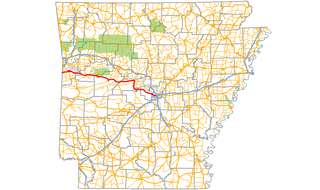
Arkansas Highway 10 is an east–west state highway in West Arkansas. The route runs 135.41 miles (217.92 km) from Oklahoma State Highway 120 near Hackett east to Interstate 30 in Little Rock, the state's capitol. The highway serves both the Fort Smith metropolitan area and the Little Rock – North Little Rock – Conway metropolitan area.
Interstate 440 (I-440) and Arkansas Highway 440 (AR 440), in the central part of the U.S. state of Arkansas, form a partial loop of 14.16 miles (22.79 km) connecting US 67, US 167, and I-40 with I-30 and I-530 near Little Rock. I-440, known as the East Belt Freeway during planning and construction, travels through much of the area's industrial core in the eastern part of the metropolitan area, near Clinton National Airport and the Port of Little Rock. The route is mostly a six-lane freeway. North of I-40, the route continues as AR 440 until it reaches US 67/US 167 in Jacksonville. This section is known as the North Belt Freeway.
Pulaski Heights is a section of the city of Little Rock, Arkansas, located in the north-central portion of the city. The area comprises two distinct neighborhoods representing an historic suburb dating from the 1890s that was among the first areas to be annexed into Little Rock.
A sizable and more recently developed section of the city, Chenal Valley is in the west-central section of Little Rock, Arkansas. Its name is derived from the area's Shinall Mountain, but Deltic Timber Corporation, a major early developer of the area, opted to alter the name to mimic French language as part of a strategy to orient the residential and commercial development toward upper-class population segments.
Brodie Creek is a traditional residential neighborhood in west Little Rock, Arkansas with close proximity to Interstate 430, Bowman Rd, Kanis Rd, Chenal Pkwy, and Col Glenn Rd.
Pleasant Valley is a neighborhood that is among the older western neighborhoods of the city of Little Rock, Arkansas. The area is to the northwest of Breckenridge and west of Colony West. Pleasant Valley lies to the south of the hillier Pleasant Ridge and Walton Heights areas, and mostly to the east of St. Charles.
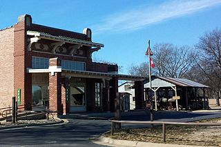
Mabelvale was a small, unincorporated train station town in southwestern Pulaski County, Arkansas, until being annexed into Little Rock following a special election that was held on May 3, 1973. The area today is part of Little Rock's seventh ward, although it retains a separate postal designation and ZIP code [72103] from most of the rest of the city. The neighborhood is currently represented on Little Rock's City Board of Directors by Brenda "B.J." Wyrick.
Broadmoor is a neighborhood of 553 homes in central Little Rock, Arkansas, located in the University District. It was developed west of Hayes Street on the western edge of the city beginning in 1953. A portion of the neighborhood lies on land occupied by the former hunting lodge of Raymond Rebsamen. A small lake near the lodge, Rebsamen Lake, was expanded in 1954 and is now known as Broadmoor Lake.
Shinall Mountain is the highest natural point in Pulaski County, Arkansas and home to a number of broadcast towers whose navigational lights can be seen for miles. It is located in the foothills of the Ouachita Mountains on the edge of Little Rock, the capital and most populous city of Arkansas.
Little Rock is the capital and most populous city of the U.S. state of Arkansas. As the county seat of Pulaski County, the city was incorporated on November 7, 1831, on the south bank of the Arkansas River close to the state's geographic center. The city derived its name from a rock formation along the river, named the "Little Rock" by the French explorer Jean-Baptiste Bénard de la Harpe in the 1720s. The capital of the Arkansas Territory was moved to Little Rock from Arkansas Post in 1821. The city's population was 197,312 in 2019 according to the United States Census Bureau. The six-county Little Rock-North Little Rock-Conway, AR Metropolitan Statistical Area (MSA) is ranked 78th in terms of population in the United States with 738,344 residents according to the 2017 estimate by the United States Census Bureau.
Highway 300 is a designation for two state highway segments in Central Arkansas. The main route of 34.11 miles (54.89 km) runs from Highway 9/Highway 10 east to Cantrell Road and Chenal Parkway in Little Rock. A second segment runs 1.45 miles (2.33 km) east from Interstate 430 as Colonel Glenn Road.
Inside Little Rock's city limits, there are numerous different neighborhoods. These include Apple Gate, Birchwood, Breckenridge, Broadmoor, Brodie Creek, Candlewood, Capitol View, Capitol View/Stifft's Station, Chenal Ridge, Cloverdale, Colony West, Downtown, East End, Echo Valley, Fair Park, Geyer Springs, Gibraltar Heights, Granite Mountain, Gum Springs, Hall High, The Heights, Highland Park, Hillcrest, John Barrow, Leawood, Mabelvale, Mushroom Pass, Oak Forest, Otter Creek, Parkway Place, Pleasant Valley, Quapaw Quarter, River Mountain, River Ridge, Riverdale, Robinwood, Rock Creek, Rosedale, St. Charles, Santa Fe Heights, Historic South End District/South Little Rock, Southwest Little Rock, Stagecoach, Sturbridge, the Villages of Wellington, Wakefield, West End and Woodland Edge.
Highway 338 is an east–west state highway in Pulaski County, Arkansas. The highway begins at Highway 5 in Little Rock and runs east, crossing three Interstate highways before terminating at Highway 365 in Sweet Home. It is maintained by the Arkansas Department of Transportation (ArDOT). The designation was also applied to a section of Roosevelt Road in Little Rock near Clinton National Airport between 1973 and 1981.
This page is based on this Wikipedia article Text is available under the CC BY-SA 4.0 license; additional terms may apply. Images, videos and audio are available under their respective licenses.