
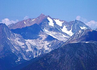
Mount Robson is the most prominent mountain in North America's Rocky Mountain range; it is also the highest point in the Canadian Rockies. The mountain is located entirely within Mount Robson Provincial Park of British Columbia, and is part of the Rainbow Range. Mount Robson is the second highest peak entirely in British Columbia, behind Mount Waddington in the Coast Range. The south face of Mount Robson is clearly visible from the Yellowhead Highway, and is commonly photographed along this route.

The Canadian Rockies or Canadian Rocky Mountains, comprising both the Alberta Rockies and the British Columbian Rockies, is the Canadian segment of the North American Rocky Mountains. It is the easternmost part of the Canadian Cordillera, which is the northern segment of the North American Cordillera, the expansive system of interconnected mountain ranges between the Interior Plains and the Pacific Coast that runs northwest–southeast from central Alaska to the Isthmus of Tehuantepec in Mexico.

The Winston Churchill Range is a mountain range in the central section of the Park Ranges of the Canadian Rockies located in Jasper National Park. The range was named after Sir Winston Churchill, former British prime minister.

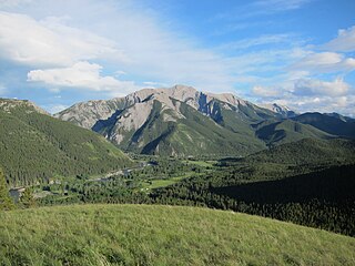
The Fairholme Range is a mountain range east of the Bow River valley in the Canadian Rockies. The range is bounded on the west side by the Trans-Canada Highway as it passes through the towns of Exshaw and Canmore, while the northern section of the range extends into Banff National Park to the southern shores of Lake Minnewanka. John Palliser named the range in 1859 after his sister Grace Fairholme, who had married William Fairholme.

The Slate Range is a mountain range of the Canadian Rockies, located in Banff National Park, Canada. The range is named after slate, the primary composition of the mountains in the area.

The Sawback Range is a mountain range of the Canadian Rockies that stretches from the Bow Valley in Alberta into southeastern Banff National Park.

The Beaverfoot Range is a mountain range in the Kootenay Ranges of the Canadian Rockies, located in southeastern British Columbia. The range extends from Cedared Creek near Spillimacheen north to the Kicking Horse River.

The Hart Ranges are a major subrange of the Canadian Rockies located in northeastern British Columbia and western Alberta. The mountains constitute the southernmost portion of the Northern Rocky Mountains.
Skihist Mountain, also sometimes referred to as Skihist Peak, is the highest mountain in the Cantilever Range and in southwestern British Columbia, Canada. It is located on the southern boundary of Stein Valley Nlaka'pamux Heritage Park, about 20 km (12 mi) west of Lytton. It is the highest summit in the Lillooet Ranges, which lie between the Lillooet and Fraser Rivers, south of the Gates Valley and Seton and Anderson Lakes.
The Northern Rocky Mountains, usually referred to as the Northern Rockies, are a subdivision of the Canadian Rockies comprising the northern half of the Canadian segment of the Rocky Mountains. While their northward limit is easily defined as the Liard River, which is the northward terminus of the whole Rockies, the southward limit is debatable, although the area of Mount Ovington and Monkman Pass is mentioned in some sources, as south from there are the Continental Ranges, which are the main spine of the Rockies forming the boundary between British Columbia and Alberta. Some use the term to mean only the area north of the Peace Arm of the Williston Reservoir, and in reference to Northern Rocky Mountains Provincial Park, while others consider the term to extend all the way south, beyond the limit of the Hart Ranges at Mount Ovington, to include the McBride area, the Sir Alexander Group and Mount Robson.

The Terminal Range is the northernmost mountain range of the Canadian Rockies, so-named for its position at the northern terminus of the Rockies. Lying west of Muncho Lake and the Trout River, its northern perimeter is the Liard River. The Sentinel Range lies to its east.
The Livingstone Range is a sub-range of the Canadian Rockies in Alberta, Canada. It forms the eastern boundary of the Rockies in the south of the province. Its northern boundary is the Highwood River and it extends to Crowsnest Pass in the south. The Livingstone and Oldman Rivers bound it to the west.
The Waputik Mountains are a mountain range of the Canadian Rockies, located on the Continental Divide between Banff and Yoho National Park. Covering an area of 1,069 square kilometres (413 sq mi), the range is located west of the Howse, Blaeberry and Amiskwi Rivers and east of the Bow and Mistaya Rivers and south to Kicking Horse Pass. Named in 1884 by George M. Dawson, "waputik" is the Stoney Indian word for white goat.

Murray Range is a subdivision range of the Hart Ranges, of the Northern Rockies in British Columbia, Canada. The majority of the range lies within the Pine-Lemoray Provincial Park and is noted for its snowmobiling, hiking and ski touring opportunities. The boundaries of the Murray Range generally lie between the Misinchinka River to the west and Mountain Creek to the east; the Pine River to the north and Mount Reynolds to the south.
Misinchinka Ranges, is the largest subdivision range of the Hart Ranges, of the Northern Rockies in British Columbia, Canada. The boundaries of the Misinchinka Ranges generally lie between the Rocky Mountain Trench to the west, Clearwater Creek and the Sukunka River to the east, the Peace Arm of Williston Reservoir to the north and Monkman Provincial Park to the south.
Solitude Range is a subdivision range of the Misinchinka Ranges of the Hart Ranges of the Northern Rockies in British Columbia, Canada. The boundaries of the Solitude Range generally lie between the Murray Range and Mountain Creek to the west, Le Moray Creek to the east, the Pine River to the north and Mount Merrick to the south.
Mount Stephenson, is a 2,037-metre (6,683 ft) mountain in the Solitude Range, a subrange of the Misinchinka Ranges of the Hart Ranges in northern British Columbia, Canada. It is named for Canadian Army Corporal Harry Stephenson, from Kilkerran. Corporal Stephenson served with the 10 Field Squadron, Canadian Engineers with the 5th Canadian Armoured Division and was killed in action on 11 September 1944, along the Italian Gothic Line, age 31. He is buried in the Gradara War Cemetery, Italy.
Watson Peak, is a 1,923-metre (6,309 ft) mountain in the Solitude Range of the Hart Ranges in Northern British Columbia.

Mount Vreeland, is a 2,464-metre (8,084 ft) mountain in the Miscinchinka Ranges of the Hart Ranges in the Northern Rocky Mountains.
Alexis Peak, is a 2,123-metre (6,965 ft) mountain in the Misinchinka Ranges of the Hart Ranges in Northern British Columbia.

