Konstantynów is a village in the administrative district of Gmina Biała Rawska, within Rawa County, Łódź Voivodeship, in central Poland. It lies approximately 7 kilometres (4 mi) south-east of Biała Rawska, 21 km (13 mi) east of Rawa Mazowiecka, and 75 km (47 mi) east of the regional capital Łódź.
Uników is a village in the administrative district of Gmina Złoczew, within Sieradz County, Łódź Voivodeship, in central Poland. It lies approximately 5 kilometres (3 mi) west of Złoczew, 27 km (17 mi) south-west of Sieradz, and 77 km (48 mi) south-west of the regional capital Łódź.
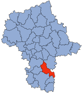
Brzeźnica is a village in the administrative district of Gmina Kozienice, within Kozienice County, Masovian Voivodeship, in east-central Poland. It lies approximately 6 kilometres (4 mi) south-east of Kozienice and 86 km (53 mi) south-east of Warsaw.
Kępeczki is a village in the administrative district of Gmina Kozienice, within Kozienice County, Masovian Voivodeship, in east-central Poland. It lies approximately 6 kilometres (4 mi) east of Kozienice and 84 km (52 mi) south-east of Warsaw.
Kuźmy is a village in the administrative district of Gmina Kozienice, within Kozienice County, Masovian Voivodeship, in east-central Poland. It lies approximately 8 kilometres (5 mi) north of Kozienice and 74 km (46 mi) south-east of Warsaw.
Nowa Wieś is a village in the administrative district of Gmina Kozienice, within Kozienice County, Masovian Voivodeship, in east-central Poland. It lies approximately 8 kilometres (5 mi) north-west of Kozienice and 73 km (45 mi) south-east of Warsaw.
Samwodzie is a village in the administrative district of Gmina Kozienice, within Kozienice County, Masovian Voivodeship, in east-central Poland. It lies approximately 7 kilometres (4 mi) east of Kozienice and 82 km (51 mi) south-east of Warsaw.
Staszów is a village in the administrative district of Gmina Kozienice, within Kozienice County, Masovian Voivodeship, in east-central Poland. It lies approximately 6 kilometres (4 mi) east of Kozienice and 85 km (53 mi) south-east of Warsaw.
Świerże Górne is a village in the administrative district of Gmina Kozienice, within Kozienice County, Masovian Voivodeship, in east-central Poland. It lies approximately 10 kilometres (6 mi) north-west of Kozienice and 72 km (45 mi) south-east of Warsaw.
Wólka Tyrzyńska is a village in the administrative district of Gmina Kozienice, within Kozienice County, Masovian Voivodeship, in east-central Poland. It lies approximately 6 kilometres (4 mi) north-east of Kozienice and 80 km (50 mi) south-east of Warsaw.
Adamów is a village in the administrative district of Gmina Głowaczów, within Kozienice County, Masovian Voivodeship, in east-central Poland. It lies approximately 5 kilometres (3 mi) east of Głowaczów, 14 km (9 mi) north-west of Kozienice, and 70 km (43 mi) south of Warsaw.
Klementynów is a village in the administrative district of Gmina Głowaczów, within Kozienice County, Masovian Voivodeship, in east-central Poland. It lies approximately 4 kilometres (2 mi) north-west of Głowaczów, 22 km (14 mi) west of Kozienice, and 68 km (42 mi) south of Warsaw.
Lipa is a village in the administrative district of Gmina Głowaczów, within Kozienice County, Masovian Voivodeship, in east-central Poland. It lies approximately 4 kilometres (2 mi) north-west of Głowaczów, 21 km (13 mi) west of Kozienice, and 68 km (42 mi) south of Warsaw.
Lipska Wola is a village in the administrative district of Gmina Głowaczów, within Kozienice County, Masovian Voivodeship, in east-central Poland. It lies approximately 5 kilometres (3 mi) west of Głowaczów, 23 km (14 mi) west of Kozienice, and 67 km (42 mi) south of Warsaw.
Koziołek is a village in the administrative district of Gmina Grabów nad Pilicą, within Kozienice County, Masovian Voivodeship, in east-central Poland. It lies approximately 5 kilometres (3 mi) south-east of Grabów nad Pilicą, 25 km (16 mi) north-west of Kozienice, and 61 km (38 mi) south of Warsaw.
Paprotnia is a village in the administrative district of Gmina Grabów nad Pilicą, within Kozienice County, Masovian Voivodeship, in east-central Poland. It lies approximately 6 kilometres (4 mi) south-east of Grabów nad Pilicą, 24 km (15 mi) north-west of Kozienice, and 61 km (38 mi) south of Warsaw.
Strzyżyna is a village in the administrative district of Gmina Grabów nad Pilicą, within Kozienice County, Masovian Voivodeship, in east-central Poland. It lies approximately 5 kilometres (3 mi) south of Grabów nad Pilicą, 28 km (17 mi) north-west of Kozienice, and 61 km (38 mi) south of Warsaw.
Zwierzyniec is a village in the administrative district of Gmina Grabów nad Pilicą, within Kozienice County, Masovian Voivodeship, in east-central Poland. It lies approximately 3 kilometres (2 mi) south-east of Grabów nad Pilicą, 27 km (17 mi) north-west of Kozienice, and 59 km (37 mi) south of Warsaw.
Przewóz Stary is a village in the administrative district of Gmina Magnuszew, within Kozienice County, Masovian Voivodeship, in east-central Poland. It lies approximately 4 kilometres (2 mi) north of Magnuszew, 26 km (16 mi) north-west of Kozienice, and 55 km (34 mi) south-east of Warsaw.
Trzebień is a village in the administrative district of Gmina Magnuszew, within Kozienice County, Masovian Voivodeship, in east-central Poland. It lies approximately 6 kilometres (4 mi) south of Magnuszew, 21 km (13 mi) north-west of Kozienice, and 61 km (38 mi) south-east of Warsaw.