Piranhas, Alagoas

Last updated
Piranhas
Municipality
Piranhas Alagoas.jpg
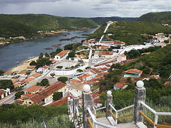
View of the centre of Piranhas looking upstream along the Rio São Francisco. The left-most building in the photo is a small part of the former railway station building (now a museum) and platform.
Bandeira Oficial de Piranhas.png
Brasao piranhas.jpg
Piranhas.png
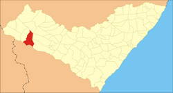
Location of Piranhas in the State of Alagoas
Brazil location map.svg
Red pog.svg
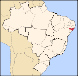
Piranhas
Location in Brazil
Coordinates: 09°37′26″S37°45′25″W / 9.62389°S 37.75694°W / -9.62389; -37.75694 Coordinates: 09°37′26″S37°45′25″W / 9.62389°S 37.75694°W / -9.62389; -37.75694
Country Brazil
State Bandeira de Alagoas.svg  Alagoas
Population
 (2020)
  Total25,183
Time zone UTC−3 (BRT)
Website Official website

Piranhas is a historic municipality near the western limit of the State of Alagoas, in the Northeast Region of Brazil.

Contents

Located on the banks of the São Francisco River, on the border with the State of Sergipe, Piranhas was founded in 1891 and originally named Floriano Peixoto (in honor of the Army General who was one of the founders of the Republic and was later elected President).

It was also known as Porto de Piranhas, because fishermen caught piranhas (a carnivorous predator fish) there.

History

The town was founded in 1891.

Its architecture is typical of late Empire, Northeast style of constructions.

In the 1930s, Piranhas was attacked several times by the cangaceiros, bands of marauders and bandits, commanded by the infamous Lampião, who frequently hid from the police in the rocky outcrops near the city.

Transport

Railway

Historically Piranhas was the upstream limit of navigation on the lower São Francisco River. Immediately upstream of Piranhas there were impassable rapids, and 60 km further upstream was the major falls at Paulo Afonso. Above those falls the São Francisco became navigable again for over 1500 km.

In 1881 Piranhas became the start of a railway line which was designed to bypass these obstacles to navigation. The line rose out of the deeply cut valley of the river and then, paralleling it at a distance of several kilometres, set off in a north-westerly direction, before rejoining it further upstream. The line passed through a series of small towns including Olho d'Água das Flores and Delmiro Gouveia, before reaching its destination at Petrolândia, on the banks of the upper São Francisco, and approximately 80 km upstream from Piranhas.

From 1881 to 1903 this railway was known as the Estrada de Ferro Paulo Afonso. After this date the line was incorporated successively in two other rail companies before closing finally in 1964. The line was never incorporated physically into any railway network, remaining a single, single track, line from beginning to end. Today the stretch of the abandoned trackbed, which climbs up the side of the valley from the centre of Piranhas, provides a walking route with views of São Francisco in the valley below and of the Xingó Dam hydroelectric installation, just upstream of the town.

Other transport

Today Piranhas can be reached by boat from several ports along the São Francisco, or by car, via a paved road from Maceió (AL-225).

Leisure

The municipality holds part of the 26,736 hectares (66,070 acres) Rio São Francisco Natural Monument, which protects the canyons of the São Francisco River between the Paulo Afonso Hydroelectric Complex and the Xingó Dam. [1]

Torre do Relogio Torre do Relogio de Piranhas.jpg
Torre do Relógio

Water sports such as catamarans, sailboats and canoes are available at river beaches and lakes, as well tours along the São Francisco using typical paddle steamers (gaiolas). Several waterfalls, the river itself, the semi-arid and rough caatinga, strange rock formations, and its river gorges are visible.

Statistics

Notable people

Related Research Articles

<span class="mw-page-title-main">Douro</span> River in Spain and Portugal

The Douro is the highest-flow river of the Iberian Peninsula. It rises near Duruelo de la Sierra in Soria Province, central Spain, meanders south briefly then flows generally west through the north-west part of central Spain and into northern Portugal, to its mouth at Porto, the second largest city of Portugal. At its mouth it meets the Atlantic Ocean.

<span class="mw-page-title-main">Saint Anthony Falls</span> Waterfall in Mississippi River into the Mississippi River Gorge in Minneapolis, Minnesota

Saint Anthony Falls, or the Falls of Saint Anthony located at the northeastern edge of downtown Minneapolis, Minnesota, is the only natural major waterfall on the Mississippi River. Throughout the mid-to-late 1800’s, various dams were built atop the east and west faces of the falls to support the milling industry that spurred the growth of the city of Minneapolis. In 1880, the central face of the falls was reinforced with a sloping timber apron to stop the upstream erosion of the falls. In the 1950s, the apron was rebuilt with concrete, which makes up the most visible portion of the falls today. A series of locks were constructed in the 1950s and 1960s to extend navigation to points upstream.

<span class="mw-page-title-main">São Francisco River</span> River in Brazil

The São Francisco River is a large river in Brazil. With a length of 2,914 kilometres (1,811 mi), it is the longest river that runs entirely in Brazilian territory, and the fourth longest in South America and overall in Brazil. It used to be known as the Opara by the indigenous people before colonisation, and is today also known as "Velho Chico".

<span class="mw-page-title-main">Paraná River</span> River in South America

The Paraná River is a river in south-central South America, running through Brazil, Paraguay, and Argentina for some 4,880 kilometres (3,030 mi). Among South American rivers, it is second in length only to the Amazon River. It merges with the Paraguay River and then farther downstream with the Uruguay River to form the Río de la Plata and empties into the Atlantic Ocean.

<span class="mw-page-title-main">Baixo Guandu</span> Municipality in Southeast, Brazil

Baixo Guandu is a municipality located in the Brazilian state of Espírito Santo that was founded on April 10, 1935 and established as a city on June 8, same year. The city's celebration day is April 10. Its population was 31,132 (2020) and its area is 918 km². The area is most well known for its exports of coffee, especially from the high mountains of the district of Alto Mutum Preto. The main watercourse through the municipality is the Rio Doce river whose basin is composed of 222 municipalities.

<span class="mw-page-title-main">Rio Grande (Paraná River tributary)</span> River in Brazil

Rio Grande is a river in south-central Brazil. It rises in the Mantiqueira Mountains in the state of Minas Gerais and descends inland, west-northwestward. Its lower course marks a portion of the Minas Gerais-São Paulo border. At the Mato Grosso do Sul state border, after a course of 1,090 km (677 mi), it joins the Paranaíba River to form the Upper Paraná River.

<span class="mw-page-title-main">Tietê River</span> River in São Paulo, Brazil

The Tietê River is a Brazilian river in the state of São Paulo.

<span class="mw-page-title-main">Paraíba do Sul</span> River in southeast Brazil

The Paraíba do Sul, or simply termed Paraíba, is a river in southeast Brazil. It flows 1,137 km (706 mi) west to northeast from its farthest source at the source of the river Paraitinga to the sea near Campos dos Goytacazes. The river receives its name when it meets the river Paraibuna at the Paraibuna dam.

<span class="mw-page-title-main">Paranapanema River</span> River in Brazil

The Paranapanema River is one of the most important rivers of the interior of the Brazilian state of São Paulo. The river forms most of the boundary between the states of São Paulo and Paraná.

<span class="mw-page-title-main">Paranaíba River</span> River in Brazil

The Paranaíba River is a Brazilian river whose source lies in the state of Minas Gerais in the Mata da Corda mountains, municipality of Rio Paranaíba, at an altitude of 1,148 meters; on the other face of this mountain chain are the sources of the Abaeté river, tributary of the São Francisco River. The length of the river is approximately 1,000 kilometres (620 mi) up to the junction with the Grande River, both of which then form the Paraná River, at the point that marks the borders of the states of São Paulo, Minas Gerais, and Mato Grosso do Sul.

<span class="mw-page-title-main">Barreiras</span> Municipality in Northeast, Brazil

Barreiras is a city located in the west of the state of Bahia, Brazil. It is the most important urban, political, technological and economic center of the western region of the state. Its economy is based on livestock raising and agriculture. In recent years it has experienced an economic boom and is one of the fastest-growing cities in the state of Bahia if not in Brazil.

<span class="mw-page-title-main">Paulo Afonso</span> Municipality in Northeast, Brazil

Paulo Afonso is a city in Bahia, Brazil. It was founded in 1958.

<span class="mw-page-title-main">Delmiro Gouveia</span> Municipality in Northeast, Brazil

Delmiro Gouveia is a municipality located in the westernmost point of the Brazilian state of Alagoas. Its population is 52,262 (2020) and its area is 609 km².

<span class="mw-page-title-main">Olho d'Água do Casado</span> Municipality in Northeast, Brazil

Olho d'Água do Casado is a municipality located in the western of the Brazilian state of Alagoas. Its population is 9,441 (2020) and its area is 323 square kilometres (125 sq mi).

<span class="mw-page-title-main">Canindé de São Francisco</span> Municipality in Northeast, Brazil

Canindé de São Francisco is a municipality located in the Brazilian state of Sergipe. Its population was 30,402 (2020) and its area is 902.2 km2 (348.3 sq mi).

<span class="mw-page-title-main">Paulo Afonso Falls</span> Series of waterfalls on the São Francisco River in Bahia, Brazil

Paulo Afonso Falls is a series of waterfalls on the São Francisco River in the north-east of Brazil adjacent to the city of Paulo Afonso.

<span class="mw-page-title-main">Petrolândia</span>

Petrolândia is a municipality in the state of Pernambuco, Brazil. It is in the São Francisco Region. Petrolândia has a total area of 1056.6 square kilometers and had an estimated population of 36,901 inhabitants in 2020 according to the IBGE. It has one of the largest GDP per capita of Sertão due to the location of one hydroelectric power plant, property of CHESF.

<span class="mw-page-title-main">Xingó Dam</span> Dam in Near Piranhas on border of Alagoas and Sergipe, Brazil

The Xingó Dam is a concrete face rock-fill dam on the São Francisco River on the border of Alagoas and Sergipe, near Piranhas, Brazil. The dam was built for navigation, water supply and hydroelectric power generation as it supports a 3,162 megawatts (4,240,000 hp) power station. It was constructed between 1987 and 1994 and the last of its generators was commissioned in 1997. In Portuguese, the dam is called the Usina Hidrelétrica de Xingó.

<span class="mw-page-title-main">Paulo Afonso Hydroelectric Complex</span> Brazilian hydroelectric project

The Paulo Afonso Hydroelectric Complex, also known as the Paulo Afonso Complex, is a system of three dams and five hydroelectric power plants on the São Francisco River near the city of Paulo Afonso in Bahia, Brazil. The complex exploits an 80-metre (260 ft) natural gap on the river, known as the Paulo Afonso Falls. Constructed in succession between 1948 and 1979, the dams support the Paulo Afonso I, II, III, IV and Apollonius Sales (Moxotó) power plants which contain a total of 23 generators with an installed capacity of 4,279.6 megawatts (5,739,000 hp).

The Rio São Francisco Natural Monument is a natural monument in the states of Alagoas, Bahia and Sergipe, Brazil. It protects a section of dramatic canyons on the São Francisco River and the surrounding caatinga environment, while supporting tourism and ecotourism.

References

  1. Unidade de Conservação: Monumento Natural do Rio São Francisco (in Portuguese), MMA: Ministério do Meio Ambiente, retrieved 2016-05-21
  2. IBGE 2020