Arcoverde is a municipality in Pernambuco, Brazil. It is located in the mesoregion of Sertão Pernambucano. Arcoverde has a total area of 353.4 square kilometers and had an estimated population of 74,822 inhabitants in 2020 according with IBGE.

Jardim Botânico is a wealthy residential neighborhood of Rio de Janeiro, Brazil, located north of Ipanema and Leblon, just across Lagoa Rodrigo de Freitas and east of Gávea. Jardim Botânico lies in the South Zone of Rio de Janeiro.

Ipatinga is a municipality in eastern Minas Gerais state, Brazil. The city was founded on 29 April 1964 and covers a total area of 164.8 km2 (63.6 sq mi). Its population is 267,333 as of 2021. It is part of the Vale do Aço metropolitan area.

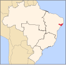
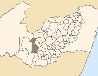
Pesqueira is a Brazilian municipality in the state of Pernambuco. It had an estimated population in 2020 according to the IBGE, of 67,735. Its area is 980.876 km².

Alagoinha is a Brazilian municipality in the state of Pernambuco. The name "Alagoinha" refers to the many small tanks, wells, cauldrons, and lagoons within the city. Nossa Senhora da Conceição Our Lady of Conceição is the patron saint of the city. The church of Nossa Senhora da Conceição, which has a simple style, was built by German Franciscan friars in 1916. The city has a strong connection to the German culture.
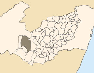
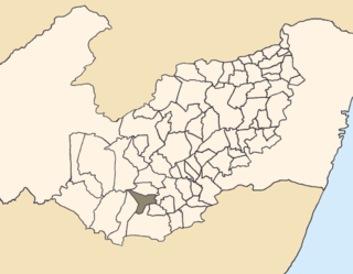
Buíque is a Brazilian municipality in the state of Pernambuco, mesoregion of Agreste. It has an estimated population of 58,919 in a total area of 1345,1 km2. The Kapinawá Indigenous Reserve is located in the municipality of Buíque.
Águas Belas is a Brazilian municipality in the state of Pernambuco.
Caetés is a Brazilian municipality located within the state of Pernambuco, in northeastern Brazil. The city belongs to the mesoregion of Agreste Pernambucano and microregion of Garanhuns. It is the birthplace of the president of Brazil Luiz Inácio Lula da Silva. The name originates from the indigenous Caetés people who lived in Pernambuco in the 16th century.

Conceição de Ipanema is a Brazilian municipality situated in state of Minas Gerais. It has an area of 234 km2. As of 2020, its population is 4,578.
Manari is a city established in 1997 in the state of Pernambuco, Brazil. The population in 2020, according to the Brazilian Institute of Geography and Statistics, was 21,776 and the area is 344.73 km². In 2000, Manari had the lowest HDI of any municipality in the state.

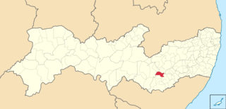
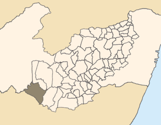
Bom Conselho is a city in northeastern Brazil, in the state of Pernambuco. It lies in the mesoregion of Agreste of Pernambuco and has 786.2 sq/km of total area.
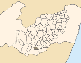
Venturosa is a city in northeastern Brazil, in the State of Pernambuco. It lies in the mesoregion of Agreste of Pernambuco and has 338.12 sq/km of total area.
Saloá is a city in the state of Pernambuco, Brazil. It is 263 km away from the state capital Recife, and has an estimated population of 15,862 inhabitants.
Pedra (stone) is a city located in the state of Pernambuco, Brazil. It is located at 255 km away from Recife, capital of the state of Pernambuco, and has an estimated population of 22,668 inhabitants.
Terezinha is a city located in the state of Pernambuco, Brazil. Located at 251 km away from Recife, capital of the state of Pernambuco, it has an estimated population of 7,198 inhabitants.

Tupanatinga is a city located in the state of Pernambuco, Brazil. Located at 306 km away from Recife, capital of the state of Pernambuco. Has an estimated population of 27,551 inhabitants.
Itaíba is a city located in the state of Pernambuco, Brazil. It is located 306 km away from Recife, the capital of the state of Pernambuco. It has an estimated population of 26,308 inhabitants.
Ipanema, Minas Gerais is a municipality in the state of Minas Gerais in the Southeast region of Brazil.

The Vale do Aço Metropolitan Region is a metropolitan area in Minas Gerais, Brazil, comprising only the four municipalities of Coronel Fabriciano, Ipatinga, Santana do Paraíso and Timóteo, but have an influence area of 22 other municipalities.

The Immediate Geographic Region of Manhuaçu is one of the 10 immediate geographic regions in the Intermediate Geographic Region of Juiz de Fora, one of the 70 immediate geographic regions in the Brazilian state of Minas Gerais and one of the 509 of Brazil, created by the National Institute of Geography and Statistics (IBGE) in 2017.