The country of Brazil occupies roughly half of South America, bordering the Atlantic Ocean. Brazil covers a total area of 8,514,215 km2 (3,287,357 sq mi) which includes 8,456,510 km2 (3,265,080 sq mi) of land and 55,455 km2 (21,411 sq mi) of water. The highest point in Brazil is Pico da Neblina at 2,994 m (9,823 ft). Brazil is bordered by the countries of Argentina, Bolivia, Colombia, Guyana, Paraguay, Peru, Suriname, Uruguay, Venezuela, and French Guiana.

Alagoas, officially State of Alagoas, is one of the 27 federative units of Brazil and is situated in the eastern part of the Northeast Region. It borders: Pernambuco ; Sergipe (S); Bahia (SW); and the Atlantic Ocean (E). Its capital is the city of Maceió. It has 1.6% of the Brazilian population and produces 0.8% of the Brazilian GDP. It is made up of 102 municipalities and its most populous cities are Maceió, Arapiraca, Palmeira dos Índios, Rio Largo, Penedo, União dos Palmares, São Miguel dos Campos, Santana do Ipanema, Delmiro Gouveia, Coruripe, and Campo Alegre.

João Pessoa is a port city in northeastern Brazil. It is the largest city in, and capital of, the state of Paraíba with an estimated population of 833,932. It is located on the right bank of the Paraíba do Norte river.

Porto Seguro, is a city located in the far south of Bahia, Brazil. The city has an estimated population of 150,658 (2020), covers 2,287 square kilometres (883 sq mi), and has a population density of 52.7 residents per square kilometer. The area that includes Porto Seguro and neighbouring Santa Cruz Cabrália and Eunápolis holds a distinctive place in Brazilian history: in 1500 it was the first landing point of Portuguese navigators, principally Pedro Álvares Cabral.

The Virgin Islands National Park is a national park of the United States preserving about 60% of the land area of Saint John, U.S. Virgin Islands, as well as more than 5,500 acres of adjacent ocean, and nearly all of Hassel Island, just off the Charlotte Amalie, Saint Thomas harbor.

Maceió, formerly sometimes Anglicised as Maceio, is the capital and the largest city of the coastal state of Alagoas, Brazil. The name "Maceió" is an Indigenous term for a spring.
Jatiuca is a beach and a neighborhood situated in Maceió, capital city of Alagoas state, Brazil. Jatiuca Beach is surrounded by palm trees and blue water, and enjoys warm weather all around the year. Its beauty attracts many Brazilian and foreign tourists.
Ponta Verde is a beach in Maceió, capital city of Alagoas, state with the most beautiful coastline in Brazil. A tip of land that rises out of the sea and is covered by green palm trees. This is the phenomenon that gave its name to one of the most frequented beaches in Maceió. In the past, it housed one of the most famous symbols of the city, “The Rhea Neck”, a palm tree whose trunk resembled a rhea's neck. It was located near the present Yacht Club Alagoas. The reefs form natural pools and it is very common, during low tides, to see tourists bathing in these pools, especially near the lighthouse. There are some stands with live music bars, restaurants, snack bars, and hotels.
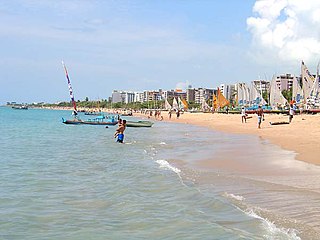
Pajuçara is a beach and a neighbourhood in Maceió, capital of Alagoas, in Brazil. This beach is approximately 2km from downtown. It is a calm water beach thanks to the reefs, which make it safe for swimming, especially for children. Near the arts and crafts fair in Pajuçara is also where the rafts leave for the natural pools formed by choral reefs, where the tourist will find floating bars.
Cabo de Santo Agostinho is a 448 square kilometer sized municipality located 35 kilometers south of the city of Recife, Pernambuco, Brazil. It is believed by some historians that Vicente Yáñez Pinzón had set anchor in a bay in Cabo de Santo Agostinho on January 26, 1500, however the Portuguese discovery of Brazil was by Pedro Álvares Cabral on April 21, 1500 is officially recognized instead. Cabo de Santo Agostinho was incorporated as a town in 1811.

Tamandarë is a coastal municipality about 103 km (64 mi) south of Recife, the capital city of the Brazilian state of Pernambuco.

Barra de São Miguel is a municipality located in the Brazilian state of Alagoas. Its population is 8,378 (2020) and its area is 77 km2.

Japaratinga is a municipality located in the Brazilian state of Alagoas. Its population is 8,403 (2020) and its area is 86 km².

Paripueira is a municipality located in the Brazilian state of Alagoas. Its population is 13,332 (2020) and its area is 93 km2.

Ipojuca is a municipality in Pernambuco in eastern Brazil. As of 2020 the population according to IBGE was 97,669 and the per capita income (2007) was R$76.418 making it one of the country's highest. The settlement dates to 1560, but the official founding date is 1861 and the community was incorporated as a town in 1864. It is famous for its beaches such as Porto de Galinhas, Muro Alto, Maracaipe.

Sirinhaém is a municipality in Pernambuco with 46,361 inhabitants. The town was founded in 1614 making it among the oldest in the state. The Mayor is Camila Machado Leocadio Lins Dos Santos.
São José da Coroa Grande is a city in the state of Pernambuco with 21,586 inhabitants. It is southernmost city of the state on the coast section.

The Rio Piranhas mangroves ecoregion covers a series of mangrove forests along the Atlantic Ocean coast of the eastern tip of Brazil. The mangrove sections are spread across 350 km, from the mouth of the Mamanguape River in the north, to the vicinity of Maceió in the south. This coast is centered on the city of Recife, and the mangrove sections often surround industrial ports and cities.

The Rio Sao Francisco mangroves ecoregion covers series of mangrove forests along the Atlantic Ocean coast of eastern Brazil, from the outskirts of Maceió southwards to just south of Salvador, Bahia. This ecoregion has high biodiversity, as it lies in different sub-climate zones, with a dry season in the north but not in the south.
Sri Lanka exhibits a remarkable biological diversity and is considered to be the richest country in Asia in terms of species concentration.