
Atanasoff Nunatak is a nunatak, a sharp peak rising to 523 m (1,716 ft) in the east extremity of Bowles Ridge, Livingston Island, Antarctica. The peak surmounts Huron Glacier to the south and east, and Struma Glacier to the north. The peak is “named in honour of the Bulgarian American John Atanasoff (1903–1995) who constructed the first electronic digital computer”.

The Debelt Glacier on Varna Peninsula, Livingston Island in the South Shetland Islands, Antarctica is situated southeast of Rose Valley Glacier and northeast of Panega Glacier. It drains the southeastern slopes of Vidin Heights and flows into Moon Bay between Edinburgh Hill and Helis Nunatak. The glacier extends three km in an east-west direction, and 1.5 km in north-south direction.

Kaliakra Glacier is a glacier in northeastern Livingston Island, Antarctica extending 3.8 nautical miles in east-west direction and 4.3 nautical miles in north-south direction, and situated southeast of Saedinenie Snowfield, southwest of Panega Glacier, north of Struma Glacier and upper Huron Glacier, and northeast of Perunika Glacier. It is bounded by Melnik Ridge and Bowles Ridge to the south, by Hemus Peak, Gurev Gap, Gleaner Heights, Elhovo Gap, Leslie Hill, Leslie Gap and Radnevo Peak to the west, and Miziya Peak and Samuel Peak to the north. The glacier drains eastwards into Moon Bay south of Perperek Knoll and north of Sindel Point.

Karnobat Pass is a 220 m wide and 720 m high pass in Levski Ridge in Tangra Mountains, Livingston Island in the South Shetland Islands, Antarctica. It is bounded by Helmet Peak to the south and Intuition Peak to the north, and is situated 5.46 km east of Lozen Saddle and 5.86 km southeast of Pirdop Gate. The pass provides overland access from Devnya Valley to Iskar Glacier area. It was named after the town of Karnobat in eastern Bulgaria.
Lozen Saddle is a 437 m high saddle situated between Lozen Nunatak and Zograf Peak in Tangra Mountains, eastern Livingston Island in the South Shetland Islands, Antarctica which provides overland access from the Wörner Gap area to the Shipka Valley. The saddle was first crossed by the Bulgarian Lyubomir Ivanov from Camp Academia on 17 December 2004, and takes its name from the adjacent Lozen Nunatak.
Maritsa Peak rises to 560 m in eastern Bowles Ridge on Livingston Island in the South Shetland Islands, Antarctica. It has precipitous rocky south slopes, and is situated on the west side of Pirdop Gate, surmounting Huron Glacier to the south and Struma Glacier to the north. The peak is "named after the Maritsa River in Bulgaria."
Montana Bluff is an ice-covered peak rising to 670 m at the end of a side ridge running south-southeast from Ticha Peak in central Bowles Ridge, Livingston Island. Surmounting Perunika Glacier to the west and southwest, and Huron Glacier to the east and southeast. It is named after the city of Montana in Northwestern Bulgaria.
Omurtag Pass is a 720 m high pass between Mount Bowles and Ticha Peak in Bowles Ridge, Livingston Island in the South Shetland Islands, Antarctica and is part of an overland route between the Wörner Gap area and upper Kaliakra Glacier. The pass is named after Khan Omurtag of Bulgaria, 814-831 AD.

Ongal Peak is a sharp glaciated peak rising to 1151 m on Levski Ridge of Tangra Mountains, Livingston Island in the South Shetland Islands, Antarctica. It surmounts Shipka Valley on the north-northwest, and Huron Glacier and its tributaries on the north and northeast.
Orpheus Gate, also Orpheus Pass, is the 548 m high and 380 m wide pass in eastern Livingston Island in the South Shetland Islands, Antarctica, bounded by Pliska Ridge to the southeast and Burdick Ridge to the northwest, Huntress Glacier to the southwest and Perunika Glacier to the northeast.
Perunika Glacier is an 8 km long and 3 km wide (average) roughly crescent-shaped glacier in eastern Livingston Island in the South Shetland Islands, Antarctica situated east of Pimpirev Glacier, south of Saedinenie Snowfield, southwest of Kaliakra Glacier, west of Huron Glacier, and north of Balkan Snowfield and the head of Huntress Glacier.
Struma Glacier is a glacier in eastern Livingston Island in the South Shetland Islands, Antarctica situated south of lower Kaliakra Glacier and north of Huron Glacier. Bounded by Melnik Ridge to the north, Yankov Gap to the west and Bowles Ridge to the south, it is 4.8 km long and 1.5 km wide, and flows eastwards into Moon Bay south of Sindel Point.
Yankov Gap is an ice-covered saddle linking Melnik Ridge and Bowles Ridge in eastern Livingston Island in the South Shetland Islands, Antarctica. The gap is at an elevation of 575 m and extends 1 km in the north-south direction from Samokov Knoll in Melnik Ridge to Asparuh Peak in Bowles Ridge. Yankov Gap is part of the divide between the glacial catchments of the head of Kaliakra Glacier to the west and Struma Glacier to the east.

Zograf Peak rises to 1,010 m (3,310 ft) at the northeast extremity of Friesland Ridge in Tangra Mountains, Livingston Island in the South Shetland Islands, Antarctica. The peak is heavily glaciated and crevassed, with precipitous and partly ice-free northern slopes. The peak surmounts Huron Glacier to the north and Shipka Valley to the east, and is accessible via the saddle of elevation 975 m linking it to the north rib of Lyaskovets Peak. The peak is linked to the northeast by Lozen Saddle to Lozen Nunatak, Erma Knoll and Aheloy Nunatak.

Camp Academia is a geographical locality in eastern Livingston Island, South Shetland Islands, Antarctica, named for the Bulgarian Academy of Sciences in appreciation of Academy’s contribution to the Antarctic exploration. The site was first occupied in the 2004/05 austral summer, and has been designated since 2004 as the summer post office Tangra 1091, the southernmost branch of the Bulgarian Posts Plc.
Bowles Ridge is the central ridge of eastern Livingston Island. The ridge extends 6.5 km in the east-west direction and is 1.5 km wide. The summit of the ridge is Mount Bowles which rises to 822m and is located 9.77 km northwest of Great Needle Peak, 6.08 km north by west of Mount Friesland, 8.77 km east-northeast of St. Kliment Ohridski base and 9.25 km south by west of Miziya Peak.

The Tangra 2004/05 Expedition was commissioned by the Antarctic Place-names Commission at the Ministry of Foreign Affairs of Bulgaria, managed by the Manfred Wörner Foundation, and supported by the Bulgarian Antarctic Institute, the Institute of Mathematics and Informatics at the Bulgarian Academy of Sciences, Bulgarian Posts, Uruguayan Antarctic Institute, Peregrine Shipping (Australia), and Petrol Ltd, TNT, Mtel, Bulstrad, Polytours, B. Bekyarov and B. Chernev (Bulgaria).
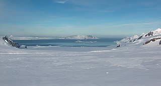
Huron Glacier is a 4.8 nautical miles } long and 2.2 nautical miles wide glacial flow on Livingston Island in the South Shetland Islands of Antarctica, situated east of Perunika Glacier, southeast of Kaliakra Glacier, south of Struma Glacier, west-northwest of Iskar Glacier and northeast of Huntress Glacier. It is bounded by Bowles Ridge to the north, Wörner Gap to the west and the Tangra Mountains to the south, receiving ice influx from several tributary glaciers draining the mountain's northern slopes between Mount Friesland and Helmet Peak, and running east-northeastwards to empty into Moon Bay north of Yana Point. Camp Academia is situated on upper Huron Glacier, in the northwestern foothills of Zograf Peak.

Elemag Reef is the 100 m long in southeast-northwest direction and 40 m wide moraine reef in Moon Bay, Livingston Island in the South Shetland Islands, with a narrow shoal extending for over 400 m eastwards. Surface area 0.33 ha. Situated 5.4 km south-southwest of Edinburgh Hill, 5.95 km west of Half Moon Island, 5.18 km northwest of Rila Point, 3.3 km northeast of Zlatograd Rock and 1.85 km east-southeast of Sindel Point. Formed at the terminus of merging Struma and Huron Glaciers, it was originally named Elemag Point. The current reef configuration is due to glacier retreat of up to 1.8 km in the area in the late 20th and early 21st century. Bulgarian mapping in 2009. Bulgarian topographic survey Tangra 2004/05 and mapping in 2009.
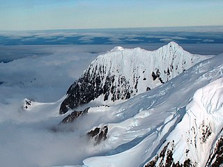
Helmet Peak is a conspicuous peak rising to 1,254 metres (4,114 ft) in Levski Ridge, Tangra Mountains on Livingston Island in the South Shetland Islands, Antarctica just southward of the mouth of Huron Glacier. It is bounded by Devnya Valley to the west, Iskar Glacier to the northeast, and Magura Glacier to the southeast, and has precipitous west and east slopes. It was named by Discovery Investigations personnel during the period 1926–32.


