Playona Acandí Fauna and Flora Sanctuary

Last updated
The Gulf of Darien (Spanish : Golfo de Darien
) Map of Darien Gap-en.svg
The Gulf of Darién (Spanish : Golfo de Darién)

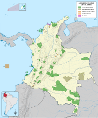
Playona Acandí Fauna and Flora Sanctuary is one of eleven new national parks in Colombia. It is the home of the Cana Turtle ( Dermochelys coriacea ). This park is on the (Uraba Gulf) Caribbean coast of the Department of Chocó. The Playon Playona Acandí Fauna and Flora Sanctuary is a strategic area for the survival of the hawksbill and leatherback turtles, the latter considered to be the world's largest sea turtle. [1]

Colombia Country in South America

Colombia, officially the Republic of Colombia, is a sovereign state largely situated in the northwest of South America, with territories in Central America. Colombia shares a border to the northwest with Panama, to the east with Venezuela and Brazil and to the south with Ecuador and Peru. It shares its maritime limits with Costa Rica, Nicaragua, Honduras, Jamaica, Haiti, and the Dominican Republic. Colombia is a unitary, constitutional republic comprising thirty-two departments, with the capital in Bogotá.

Leatherback sea turtle Species of marine reptile in the family Chelonidae

The leatherback sea turtle, sometimes called the lute turtle or leathery turtle or simply the luth, is the largest of all living turtles and is the fourth-heaviest modern reptile behind three crocodilians. It is the only living species in the genus Dermochelys and family Dermochelyidae. It can easily be differentiated from other modern sea turtles by its lack of a bony shell, hence the name. Instead, its carapace is covered by skin and oily flesh.

Caribbean Sea A sea of the Atlantic Ocean bounded by North, Central, and South America

The Caribbean Sea is a sea of the Atlantic Ocean in the tropics of the Western Hemisphere. It is bounded by Mexico and Central America to the west and south west, to the north by the Greater Antilles starting with Cuba, to the east by the Lesser Antilles, and to the south by the north coast of South America.

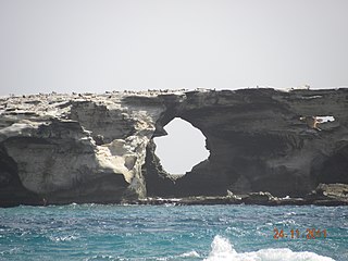
With a total extension of 26,232 hectares, it is located in the Gulf of Darién on the Caribbean Coast, within the jurisdiction of the Municipality of Acandí, encompassing the beach and adjacent marine waters next to La Playona and some part of El Playón de Acandí. [1]

Acandí Municipality and town in Chocó Department, Colombia

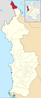
Acandí is a town in Colombia at the northern end of the department of Chocó in northwest of Colombia, bordering the Caribbean Sea. It is 366 km (227 mi) from the provincial capital, Quibdó. Its average temperature is 28 degrees Celsius (82 °F). It was founded around the year 1887, and it became a municipality in 1905, previously being part of Turbo. The name "Acandí" is a corruption of the indigenous word "Acanti", which means "River of Stone".

This zone is considered to be one of the main nesting sites of the leatherback sea turtle. Several authors and researchers belonging to the local Afro community (GILA group) state that each year over 200 turtles reach these beaches to lay their eggs. The Darién area and, particularly, the Acandí beaches, are equally important sites for the nesting of the hawksbill turtle in the Caribbean. [1]

Turtle order of reptiles

Turtles are diapsids of the order Testudines characterized by a special bony or cartilaginous shell developed from their ribs and acting as a shield. "Turtle" may refer to the order as a whole or to fresh-water and sea-dwelling testudines. The order Testudines includes both extant (living) and extinct species. The earliest known members of this group date from 220 million years ago, making turtles one of the oldest reptile groups and a more ancient group than snakes or crocodilians. Of the 356 known species alive today, some are highly endangered.

The selection of the two beaches contributes directly to the protection of these two species which are critically endangered. Their migratory nature makes this area really important since all the local conservation efforts have a significant impact on the western Caribbean. Mark and recapture studies have shown that some of the females breeding in Colombia spend most of the year in Costa Rica and Mexico. In addition, this area contributes to the protection of other animals that are socially, economically and culturally important, including several shrimps and fish. [1]

Costa Rica Country in Central America

Costa Rica, officially the Republic of Costa Rica, is a country in Central America, bordered by Nicaragua to the north, the Caribbean Sea to the northeast, Panama to the southeast, the Pacific Ocean to the southwest, and Ecuador to the south of Cocos Island. It has a population of around 5 million in a land area of 51,060 square kilometers. An estimated 333,980 people live in the capital and largest city, San José with around 2 million people in the surrounding metropolitan area.

Mexico Country in the southern portion of North America

Mexico, officially the United Mexican States, is a country in the southern portion of North America. It is bordered to the north by the United States; to the south and west by the Pacific Ocean; to the southeast by Guatemala, Belize, and the Caribbean Sea; and to the east by the Gulf of Mexico. Covering almost 2,000,000 square kilometres (770,000 sq mi), the nation is the fifth largest country in the Americas by total area and the 13th largest independent state in the world. With an estimated population of over 120 million people, the country is the tenth most populous state and the most populous Spanish-speaking state in the world, while being the second most populous nation in Latin America after Brazil. Mexico is a federation comprising 31 states and Mexico City, a special federal entity that is also the capital city and its most populous city. Other metropolises in the state include Guadalajara, Monterrey, Puebla, Toluca, Tijuana and León.

Shrimp Decapod crustaceans

The term shrimp is used to refer to some decapod crustaceans, although the exact animals covered can vary. Used broadly, shrimp may cover any of the groups with elongated bodies and a primarily swimming mode of locomotion – most commonly Caridea and Dendrobranchiata. In some fields, however, the term is used more narrowly and may be restricted to Caridea, to smaller species of either group or to only the marine species. Under the broader definition, shrimp may be synonymous with prawn, covering stalk-eyed swimming crustaceans with long narrow muscular tails (abdomens), long whiskers (antennae), and slender legs. Any small crustacean which resembles a shrimp tends to be called one. They swim forward by paddling with swimmerets on the underside of their abdomens, although their escape response is typically repeated flicks with the tail driving them backwards very quickly. Crabs and lobsters have strong walking legs, whereas shrimp have thin, fragile legs which they use primarily for perching.

Local communities adjacent to La Playona and Playón de Acandí consider the leatherback turtle a symbol and part of the region's cultural, touristic and ecological heritage. For instance, on Easter 1993 the "Leatherback Turtle Festival" began as a strategy to create awareness of the importance of this species. The area also contributes to maintain marine biodiversity and the artisanal fisheries of Urabá and Darién. More than 80 species make up the fishing resources for the community of Acandí. [1]

Gulf of Urabá gulf

The Gulf of Urabá is a gulf on the northern coast of Colombia. It is part of the Caribbean Sea. It is a long, wide inlet located on the coast of Colombia, close to the connection of the continent to the Isthmus of Panama. The town of Turbo, Colombia, lies at the mid eastern side naturally sheltered by the Turbo Bay part of the Gulf. The Atrato River flows into the Gulf of Urabá.

Darién Gap break in the Pan-American Highway consisting of a large swath of undeveloped swampland and forest

The Darién Gap is a break in the Pan-American Highway consisting of a large swath of undeveloped swampland and forest within Panama's Darién Province in Central America and the northern portion of Colombia's Chocó Department in South America. The gap begins in Yaviza, Panama and ends in Turbo, Colombia, and is 106 km long. Roadbuilding through this area is expensive and the environmental cost is high. Political consensus in favor of road construction has not emerged.

Since the beginning, the declaration of this new protected area was sought by the Afro Communities Councils of the Tolo River Basin and the Southern Coastal Zone (Cocomasur); the Acandí Seco River Basin, El Cedro and El Juancho (Cocomaseco) and the Acandí River and the Northern Coastal Zone (Cocomanorte). It was also supported, through technical collaboration by WWF Colombia during almost 10 years. In order to properly manage the planning of the Sanctuary, a coordination mechanism will be established among the three community councils and National Parks to achieve the conservation goals. [1]

World Wide Fund for Nature international non-governmental organization

The World Wide Fund for Nature (WWF) is an international non-governmental organization founded in 1961, working in the field of the wilderness preservation, and the reduction of human impact on the environment. It was formerly named the World Wildlife Fund, which remains its official name in Canada and the United States.

Related Research Articles

Meru Betiri National Park national park in Indonesia

Meru Betiri National Park is a national park in the province of East Java, Indonesia, extending over an area of 580 km2 of which a small part is marine (8.45 km2). The beaches of the park provide nesting grounds for endangered turtle species such as leatherback turtles, hawksbill turtles, green turtles, and olive ridley turtles.

Buck Island Reef National Monument national monument in the United States

Buck Island Reef National Monument, or just Buck Island is a small, uninhabited, 176 acre island about 1.5 miles (2.4 km) north of the northeast coast of Saint Croix, U.S. Virgin Islands. The monument also includes 18,839 acres of submerged lands totaling 19,015 acres. It was first established as a protected area by the U.S. Government in 1948, with the intention of preserving “one of the finest marine gardens in the Caribbean Sea.” The U.S. National Monument was created in 1961 by John F. Kennedy and greatly expanded in 2001 by Bill Clinton, over the bitter opposition of local fishermen. Buck Island National Monument is one of few places in the Virgin Islands where brown pelicans and threatened least terns nest.

Jiquilisco Bay

The Jiquilisco Bay Biosphere Reserve is located on the southeast Pacific coast of El Salvador, in the department of Usulután. Jiquilisco Bay's mangrove-lined inlets and bay hosts the largest abundance of coastal-marine birds in the El Salvador, many of which are threatened or endangered. Over 80 species of migratory birds visit the area to feed on the bay's fish, which include species such as snook, red snapper and corvina. The natural environment of Bahia Jiquilisco has recently led to an increase in eco-tourism in the area.

Riosucio, Chocó Municipality and town in Chocó Department, Colombia

Riosucio is a municipality and town in the Department of Chocó, Colombia. The municipality and town are located in the Atrato River basin, on the Chocoan side of Urabá, a region spanning the departments Chocó and Antioquia.

The Padre Ramos Estuary Natural Reserve is located on the northwest Pacific coast of Nicaragua, in the municipality El Viejo in the department of Chinandega. It is one of 78 protected areas of Nicaragua and is managed by Ministry of the Environment and Natural Resources (MARENA). Estero Padre Ramos consists of a large mangrove estuary surrounded by several small beach communities, the largest of which is the town of Padre Ramos. The area's natural environment is home to a number of species of migratory and resident birds, fishes, crustaceans, sea turtles and other wildlife. While increasing in popularity as a tourist destination, tourism remains relatively well controlled in the area.

Godavaya or Godawaya is a small fishing hamlet located at the mouth of the Walawe river, between Ambalantota and Hambantota in the Hambantota District in southern Sri Lanka.

Fauna of Pakistan

Pakistan's native fauna reflect its varied climatic zones.

Hawksbill sea turtle Species of marine reptile in the family Chelonidae

The hawksbill sea turtle is a Critically Endangered sea turtle belonging to the family Cheloniidae. It is the only extant species in the genus Eretmochelys. The species has a worldwide distribution, with Atlantic and Indo-Pacific subspecies—E. i. imbricata and E. i. bissa, respectively.

Ecology Project International is a non-profit organization based in Missoula, Montana, dedicated to developing place-based, ecological education partnerships between local experts and youth to address conservation issues. Ecology Project International (EPI) works with students and educators at seven program sites around the world: Belize, Costa Rica, mainland Ecuador, Galápagos Islands, Hawaii, Mexico, and Yellowstone.

Capurganá is a tourist destination of the municipality of Acandí on the northwestern coast of the Gulf of Urabá in the Colombian department of Choco and adjacent to the border between Colombia and Panama. This region of Colombia was inhabited by the Cuna Indians and the name Capurgana translates to the "land of chili" in their language. The Cuna inhabited until the early twentieth century when they were displaced by mostly mulatto settlers from Cartagena. The natives migrated to the archipelago of San Blas in the neighboring country of Panama. The Cuna maintain a semiautonomous region where they exercise a degree of self governance.

Northeast Ecological Corridor Protected Nature Reserve in Puerto Rico, US

The Northeast Ecological Corridor Nature Reserve (NECNR) refers to an area designated as a protected Nature Reserve located on the northeast coast of Puerto Rico, between the municipalities of Luquillo and Fajardo. Specifically, the lands that comprise the NEC are located between Luquillo's town square to the west and Seven Seas Beach to the east, being delineated by PR Route # 3 to its south and the Atlantic Ocean to its north. It was decreed as a protected area by former Puerto Rico Governor Aníbal S. Acevedo-Vilá in April 2008, a decision reversed by Governor Luis G. Fortuño-Burset in October 2009, although he later passed a law in June 2012 re-designated as nature reserve two-thirds of its lands, after intense lobbying and public pressure. Later, in 2013, Governor Alejandro García-Padilla signed a law declaring all lands within the NEC a nature reserve. The area comprises 2,969.64 acres, which include such diverse habitats as forests, wetlands, beaches, coral communities, and a sporadically bioluminescent lagoon. The Corridor is also home to 866 species of flora and fauna, of which 54 are considered critical elements, meaning rare, threatened, endangered and endemic species classified by the Puerto Rico Department of Natural and Environmental Resources (DNER), some even designated as critically endangered by the International Union for Conservation of Nature and Natural Resources (IUCN). These include, among others, federally endangered species such as the plain pigeon, the snowy plover, the Puerto Rican boa, the hawksbill sea turtle and the West Indian manatee. The beaches along the NEC, which are 8.74 kilometers long are important nesting grounds for the leatherback sea turtle, which starts its nesting season around April each year.

Ilhéu de Curral Velho and adjacent coast Important Bird Area

The Ilhéu de Curral Velho and adjacent coast Important Bird Area lies in the southeastern part of the island of Boa Vista in the Cape Verde archipelago off the coast of north-west Africa in the Atlantic Ocean. It is a 986 ha site consisting of the Ilhéu de Curral Velho, as well as the area opposite it on Boa Vista centred on the deserted village of Curral Velho. It was designated as a Ramsar wetland of international importance on July 18, 2005.

Ría Lagartos Biosphere Reserve Biosphere Reserve in the state of Yucatán, Mexico, established 2004

Ría Lagartos Biosphere Reserve is a UNESCO Biosphere Reserve in the state of Yucatán, Mexico. The reserve is located at the eastern end of the coastal strip of the Yucatán Peninsula, with the Gulf of Mexico at its northern limit. The area encompasses coastal areas of the Gulf of Mexico and includes important wetlands designated under the Ramsar Wetlands Convention. The site presents a rich diversity of landscapes and ecosystems, such as mangroves, small estuaries, medium semi-evergreen forest, low deciduous forest, coastal dune vegetation, coastal lagoons, marshes (petenes) and savanna represented by tular vegetation, grasslands and reed beds that are the main nesting sites for marshland and sea birds.

The Gales Point Wildlife Sanctuary is in the Belize district approximately 23.7 southwest of Belize City and 34 km north of Dangriga. The Sanctuary includes Southern Lagoon, Sapodilla Lagoon, Western Lagoon, Quashie Trap Lagoon and a portion of the Manatee river. It has a shoreline of 66-foot that is along all the lagoons and waterways except for the peninsula. The Wildlife Sanctuary covers a complex matrix of creeks, mangroves, mudflats and brackish lagoons. Both the rivers and creeks drains into the lagoon from the west. The lagoon is also connected to the Caribbean Sea via the Bar River.

Amazon-Orinoco-Southern Caribbean mangroves

The Amazon-Orinoco-Southern Caribbean mangroves (NT1401) is an ecoregion along the coasts of Colombia, Venezuela, Guyana, Suriname, French Guiana and Brazil.

Magdalena-Urabá moist forests

The Magdalena-Urabá moist forests (NT0137) is an ecoregion in the north of Colombia. The terrain is largely flat or undulating, but includes mountainous areas in the south. It contains moist forests and large wetlands that are important to resident and migratory birds. The ecoregion forms a bridge between the Pacific coast ecoregions of Colombia and Central America, and the ecoregions of the Andes and Amazon. It is surrounded by the more populated parts of Colombia and is threatened by farming, ranching, logging, oil exploitation and water pollution in the main rivers.

Utría National Natural Park

The Utría National Natural Park is a national park in the Chocó Department, Colombia. It contains diverse flora and fauna in a lush, mountainous rainforest environment with some of the highest rainfall in the world, at up to 10,000 millimetres (390 in) annually. The park also protects the coastal marine environment, and is known for visits by humpback whales, who give birth in the lagoon after which the park is named, and sea turtles who nest on the beaches. There is accommodation for visitors, and ecotourism services are provided by the local indigenous people and members of the coastal Afro-Colombian communities.

Unguía Fault

The Unguía Fault is an oblique dextral thrust fault in the department of Chocó in northwestern Colombia and continuing offshore Panama in the Caribbean Sea. The fault has a total length of 139.9 kilometres (86.9 mi) and is arcuate, running along a strike of 356.3 ± 30.

References

  1. 1 2 3 4 5 6 "The Playon Playona Acandí Fauna and Flora Sanctuary". peru.panda.org. Retrieved 1 April 2014.