Las Hermosas National Natural Park

Last updated
Parque Nacional Natural Las Hermosas
Las Hermosas National Natural Park
IUCN category II (national park)

Hermosas JAL.jpg

Laguna Las Mellizas, Las Hermosas National Natural Park
Colombia relief location map.jpg
Red pog.svg
Nearest city Santiago de Cali, Colombia
Coordinates 3°32′N75°57′W / 3.533°N 75.950°W / 3.533; -75.950 Coordinates: 3°32′N75°57′W / 3.533°N 75.950°W / 3.533; -75.950
Area 1,250 km2 (480 sq mi)
Established May 1977 [1]
Governing body SINAP

The Las Hermosas National Natural Park (Spanish : Parque Nacional Natural Las Hermosas) is a national park located in the Valle del Cauca and Tolima departments, at the highest elevation [2] of Cordillera Central range in the Andean Region of Colombia. Its main feature is probably the wetlands and 387 glacial lakes. [2]

Spanish language Romance language

Spanish or Castilian is a Romance language that originated in the Castile region of Spain and today has hundreds of millions of native speakers in the Americas and Spain. It is a global language and the world's second-most spoken native language, after Mandarin Chinese.

National park park used for conservation purposes of animal life and plants

A national park is a park in use for conservation purposes. Often it is a reserve of natural, semi-natural, or developed land that a sovereign state declares or owns. Although individual nations designate their own national parks differently, there is a common idea: the conservation of 'wild nature' for posterity and as a symbol of national pride. An international organization, the International Union for Conservation of Nature (IUCN), and its World Commission on Protected Areas (WCPA), has defined "National Park" as its Category II type of protected areas.

Valle del Cauca Department Department in Andean Region/Pacific Region, Colombia

Valle del Cauca, or Cauca Valley is a department of Colombia. It is on the western side of the country, abutting the Pacific Ocean. Its capital is Santiago de Cali. Such other cities as Buenaventura, Cartago and Tuluá have great economical, political, social and cultural influence on the department's life. Valle del Cauca has the largest number of independent towns with over 100,000 inhabitants in the country, counting six within its borders. Buenaventura has the largest and busiest seaport in Colombia, moving about 8,500,000 tons of merchandise annually.

Contents

General

The park is bounded by the Magdalena River and Cauca River. [3] Its elevation ranges from 1,600 m (5,200 ft) to 4,400 m (14,400 ft) above mean sea level. [2] The area has a canyon, formed by the surrounding rivers, but it is hard to access. It is of historical importance as it was one of the most defended areas by the indigenous Pijao peoples against the Spanish Conquistadors. [4]

Magdalena River river in Colombia

The Magdalena River is the principal river of Colombia, flowing northward about 1,528 kilometres (949 mi) through the western half of the country. It takes its name from the biblical figure Mary Magdalene. It is navigable through much of its lower reaches, in spite of the shifting sand bars at the mouth of its delta, as far as Honda, at the downstream base of its rapids. It flows through the Magdalena River Valley.

Cauca River river in Colombia

The Cauca River is a river in Colombia that lies between the Occidental and Central cordilleras. From its headwaters in southwestern Colombia near the city of Popayán, it joins the Magdalena River near Magangué in Bolívar Department, and the combined river eventually flows out into the Caribbean Sea. It has a length of 965 km (600 mi) to its junction with the Magdalena, for a total length of 1,350 km (840 mi). from origin to seamouth. The river is under the supervision of the Corporación Regional del Cauca and the Corporación Autonoma Regional del Valle del Cauca, and is navigable for 640 km (400 mi) above its junction with the Magdalena.

Canyon Deep ravine between cliffs

A canyon or gorge is a deep cleft between escarpments or cliffs resulting from weathering and the erosive activity of a river over geologic timescales. Rivers have a natural tendency to cut through underlying surfaces, eventually wearing away rock layers as sediments are removed downstream. A river bed will gradually reach a baseline elevation, which is the same elevation as the body of water into which the river drains. The processes of weathering and erosion will form canyons when the river's headwaters and estuary are at significantly different elevations, particularly through regions where softer rock layers are intermingled with harder layers more resistant to weathering.

Three types of geological formations are found in the area: intrusive igneous rocks, metamorphic rock and formations from more recent volcanic eruptions. [5]

Metamorphic rock Rock which was subjected to heat and pressure causing profound physical or chemical change

Metamorphic rocks arise from the transformation of existing rock types, in a process called metamorphism, which means "change in form". The original rock (protolith) is subjected to heat and pressure, causing profound physical or chemical change. The protolith may be a sedimentary, igneous, or existing metamorphic rock.

Climate

Average yearly rainfall is 2000 mm at the lower elevations and 1500 mm above 3,000 m (9,800 ft). Average temperature is 24°C at the lower elevations, and 4°C at the highest. December-March and July-August are dry periods. [4]

Flora and fauna

Noteworthy plants include: wax palm trees, Podocarpus oleifolius , Aniba perutilis , Ocotea heterochroma , Chuquiraga jussieui , Passiflora tenerifensis and Andean Walnut. [6]

<i>Ceroxylon quindiuense</i> species of plant

Ceroxylon quindiuense is a palm native to the humid montane forests of the Andes in Colombia and northern Peru.

<i>Podocarpus oleifolius</i> species of plant

Podocarpus oleifolius is a species of conifer in the Podocarpaceae family. It is found in Colombia, Costa Rica, Ecuador, El Salvador, Guatemala, Honduras, Mexico, Panama, Peru, and Venezuela.

<i>Chuquiraga jussieui</i> species of plant

Chuquiraga jussieui, the flower of the Andes, is a species of flowering plant in the Asteraceae family. It is a low shrub, reaching a height of about 75 cm. Flowers are pale yellow or orange. It is native to Ecuador and Peru. The hummingbirds Oreotrochilus chimborazo feed on the nectar.

The most diverse group of fauna are the birds, followed by the mammals and reptiles. [4] Recorded mammals include: spectacled bear, mountain tapir, cougar, oncilla, pudú, white-tailed deer. [6] Fish in the glacial lakes feed on green algae, blue-green algae and unicellular algae found throughout the 387 lakes. [4]

Spectacled bear species of mammal

The spectacled bear, also known as the Andean bear or Andean short-faced bear and locally as jukumari (Aymara), ukumari (Quechua) or ukuku, is the last remaining short-faced bear. Its closest relatives are the extinct Florida spectacled bear, and the giant short-faced bears of the Middle to Late Pleistocene age. Spectacled bears are the only surviving species of bear native to South America, and the only surviving member of the subfamily Tremarctinae. The species is classified as Vulnerable by the IUCN because of habitat loss.

Mountain tapir species of mammal

The mountain tapir or woolly tapir is the second-smallest of the five species of tapir, only the recently described Tapirus kabomani being smaller, and is the only one to live outside of tropical rainforests in the wild. It is most easily distinguished from other tapirs by its thick woolly coat and white lips.

Cougar Large cat of the family Felidae native to the Americas

The cougar, also commonly known by other names including catamount, mountain lion, panther, and puma, is a large felid of the subfamily Felinae native to the Americas. Its range, from the Canadian Yukon to the southern Andes of South America, is the widest of any large wild terrestrial mammal in the Western Hemisphere. An adaptable, generalist species, the cougar is found in most American habitat types. It is the biggest cat in North America, and the second-heaviest cat in the New World after the jaguar. Secretive and largely solitary by nature, the cougar is properly considered both nocturnal and crepuscular, although daytime sightings do occur. The cougar is more closely related to smaller felines, including the domestic cat, than to any species of subfamily Pantherinae, of which only the jaguar is native to the Americas.

Footnotes

  1. IUCN 1982, p. 134
  2. 1 2 3 Villegas & Sesana 2007 , p. 169
  3. "Parque Nacional Natural Las Hermosas" (in Spanish). Parques Nacionales Naturales de Colombia. Archived from the original on 22 July 2011. Retrieved 10 July 2010.
  4. 1 2 3 4 Villegas & Sesana 2007 , p. 170
  5. IUCN 1982 , p. 135
  6. 1 2 "Naturaleza y Ciencia del Parque Nacional Natural Las Hermosas" (in Spanish). Parques Nacionales Naturales de Colombia. Archived from the original on 22 July 2011. Retrieved 10 July 2010.

Related Research Articles

Sierra Nevada de Santa Marta mountain range

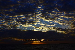
The Sierra Nevada de Santa Marta is an isolated mountain range separated from the Andes chain that runs through Colombia. Reaching an altitude of 5,700 m (18,700 ft) just 42 km (26 mi) from the Caribbean coast, the Sierra Nevada is one of the world's highest coastal ranges, being 250m shorter than the Saint Elias Mountains in Canada. The Sierra Nevada encompasses about 17,000 km2 (6,600 sq mi) and serves as the source of 36 rivers. The range is in the Departments of Magdalena, Cesar and La Guajira.

Munchique National Natural Park

The Munchique National Natural Park is a national park located in the Cauca Department in the Cordillera Occidental range in the Andean Region of Colombia. There are 30 streams and rivers, and 40 waterfalls in the area. The diversity of thermal levels makes the park a paradise for birds, especially hummingbirds.

Los Nevados National Natural Park protected area

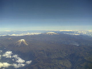
Los Nevados National Natural Park is a national park located in the Cordillera Central of the Colombian Andes. The park sourrounds the northern volcanic complex formed by Nevado del Ruiz, Nevado del Tolima, Nevado de Santa Isabel, the paramillos of Cisne, Santa Rosa and Quindío and the Cerro Bravo and Cerro Machín.

Cueva de los Guácharos

Cueva de los Guácharos National Natural Park is the oldest national park in Colombia. Located in the western face of the Colombian Eastern Andean Range in the departments of Huila and Caquetá, the park covers an area of 9,000 hectares. The caves formed from the karstic zones of the Magdalena and Caquetá rivers.

Serranía del Pinche

The Serranía del Pinche are part of the Western Ranges of the Colombian Andes. The mountains consist of several high peaks with small patches of isolated páramo and provide a corridor between the Pacific and Andean biogeographic regions. It is located municipality of Argelia in the Department of Cauca. This area is under consideration for protection as a Flora and Fauna Sanctuary by the Colombian government. This area is important for its incredible biodiversity and high percentage of primary forest. An endemic hummingbird - the gorgeted puffleg - is only found here and the population is considered to be critically endangered.

Farallones de Cali mountain in Colombia

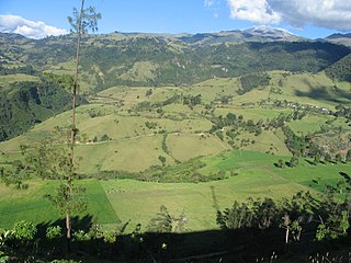
Farallones de Cali is a cluster of mountains in the West Andes of Colombia. It is located west of the city of Cali and gives rise to many of the rivers that provide water and electricity to Cali. The PNN Farallones de Cali encompasses 150,000 ha (580 sq mi) in the mountains as well as much of the Pacific slope and is an area of very high biodiversity.. The average temperature ranges from 25 °C (77 °F) in the tropical foothills to 5 °C (41 °F) in the páramo.

San Guillermo National Park national park

San Guillermo National Park is a national park in Argentina, in the Iglesia Department of San Juan Province. It was established in 1998 and is part of the San Guillermo Biosphere Reserve. Elevations in the biosphere range from 2,100 metres (6,900 ft) to 6,380 metres (20,930 ft). Vegetation in the National Park and biosphere consists of barren desert, grasslands, and a few wetlands, all located in the high, arid Andes. The animals include vicuña, guanaco, culpeo fox, Andean mountain cat, cougar, and Andean condor.

Los Estoraques Unique Natural Area protected area

The Los Estoraques Unique Natural Area is one of the smaller national parks, covering only 6 km2 (2.3 sq mi), located in the Cordillera Oriental of Colombia in the Norte de Santander Department. The landscape is shaped by large brownstone pedestals and columns formed by thousands of years of erosion. The area is part of the Catatumbo River basin and elevation range from 1,450 to 1,900 meters above mean sea level. It was declared an Área Natural Única in 1998.

Old Providence McBean Lagoon National Natural Park

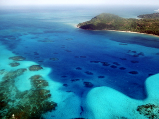
The Old Providence McBean Lagoon National Natural Park is a national park located on the northeast side of Providencia Island in the Archipelago of San Andrés, Providencia and Santa Catalina, Colombia.

Rosario and San Bernardo Corals National Natural Park

The Rosario and San Bernardo Corals National Natural Park is a natural park located in the Sucre and Bolívar Departments on the coast of the Caribbean Region of Colombia, 45 km from the Bay of Cartagena. It was the most visited national park in Colombia in 2009, with 318,473 visitors.

El Tuparro National Natural Park protected area

El Tuparro National Natural Park is a national park located in the Vichada Department in the Orinoquía Region of Colombia. It is the only protected area in the Eastern Plains under Colombia's Natural Parks System.

Salamanca Island Road Park

The Salamanca Island Road Park is a national park located in the Caribbean Region of Colombia, on the western outskirts of the city of Ciénaga in the Magdalena Department. The flora and fauna is in abundance because of the confluence of sweet water flowing from the Magdalena River and saline water of the Caribbean Sea. It was created in 1964 to protect the abundant bird life and coastal mangroves.

El mono Hernández Cork Forest Flora and Fauna Sanctuary

The "El mono Hernández" Cork Forest Flora and Fauna Sanctuary is a natural monument located in the Sucre and Bolívar Departments on the coast of the Caribbean Region of Colombia.

Tamá National Natural Park protected area

The Tamá National Natural Park is a national park located in the Tamá Massif of the Andean Region of Colombia, between the municipalities Toledo and Herrán, in the department of Norte de Santander, in the northeastern part of the Eastern Ranges of the Colombian Andes. One of the main attractions of the park is a 820-metre-high (2,690 ft) waterfall, one of the world's highest.

Puracé National Natural Park Protected area in Colombia

The Puracé National Natural Park is a national park located in the Andean Region of Colombia, southeast of the city of Popayán in the Cordillera Central range. Its main feature is the active stratovolcano Puracé, one of Colombia's most active volcanoes. Four of the country's most important rivers originate within the area: Magdalena River, Cauca River, Japurá River and Patía River.

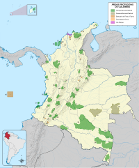
The National System of Protected Areas (SINAP) is the Colombian national park administrator. It is a department under the Ministry of the Environment, Housing and Regional Development responsible for the conservation and sustainable use of biological diversity. SINAP was established after Colombia signed the Convention on Biological Diversity through Law 165 of 1994, and has been the primary activity of the Colombian Government regarding the conservation of biodiversity. The areas of the Park System supply 25 million people with water.

Chingaza National Natural Park national park

Chingaza National Natural Park is located in the Eastern Ranges of the Colombian Andes, northeast of Bogotá, Colombia in the departments of Cundinamarca and Meta. The elevation in the park, to the east of the Altiplano Cundiboyacense, ranges from 800 metres (2,600 ft) to 4,020 metres (13,190 ft), and the temperature ranges from 4 to 21.5 °C. The park extends over the Cundinamarca municipalities La Calera, Fómeque, Guasca and San Juanito (Meta).

Biodiversity of Colombia

Colombia is the country with the second-highest biodiversity in the world, behind Brazil. As of 2016, 56,343 species are registered in Colombia, of which 9,153 are endemic. The country occupies the first position worldwide in number of orchids and birds, second position in plants, amphibians, butterflies and fresh water fish, third place in species of palm trees and reptiles and globally holds the fourth position in biodiversity of mammals.

Tamá Massif

The Tamá Massif is a group of mountains on the border between Colombia and Venezuela to the south of Lake Maracaibo. It contains evergreen rainforest and cloud forest at the lower levels, and páramos at the highest levels.

References