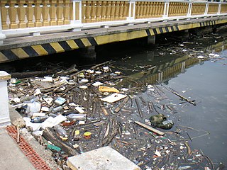
The Rio Negro or Guainía as it is known in its upper part, is the largest left tributary of the Amazon River, the largest blackwater river in the world, and one of the world's ten largest rivers by average discharge.

Protected areas of Brazil included various classes of area according to the National System of Conservation Units (SNUC), a formal, unified system for federal, state and municipal parks created in 2000.

Environmentally, Colombia is a mega-diverse country from its natural land terrain to its biological wildlife. Its biodiversity is a result of its geographical location and elevation. It is the fourth largest South American country and only country in South America to have coasts on the Pacific and Caribbean Sea. Colombia's terrain can be divided into six main natural zones: The Caribbean, the Pacific, The Orinoco region, The Amazonia region, the Andean region, and the Insular region. 52.2% of the environment is predominately the Andes, Amazon, and Pacific Basins, followed by the Orinoco basin 13.9%, the Andes and the Caribbean. The Tropical Andes, Choco, and the Caribbean are considered biodiversity hotspots which puts these areas at high risk of concentration of colonizing activities. Colombia hosts over 1800 species and at least one new species is detected every year. Decades of civil war and political unrest has impeded biological and environmental research in Colombia. The political unrest in Colombia catalyzes the alteration of land patterns through the cultivation of coca and opium crops, the redirection of extractive activities, and land abandonment in some areas.

The Munchique National Natural Park is a national park located in the Cauca Department in the Cordillera Occidental range in the Andean Region of Colombia. There are 30 streams and rivers, and 40 waterfalls in the area. The diversity of thermal levels makes the park a paradise for birds, especially hummingbirds.

The Cocora valley is a valley in the department of Quindío in the country of Colombia. It is located in the Central Cordillera of the Andean mountains. "Cocora" was the name of a Quimbayan princess, daughter of the local chief Acaime, and means "star of water".

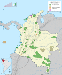
Bahía Portete – Kaurrele National Natural Park is a national natural park in Uribia, La Guajira, Colombia. The northernmost national park of mainland South America is located at the Caribbean coast of the La Guajira peninsula in Bahía Portete, between Cabo de la Vela and Punta Gallinas. Established on December 20, 2014, it is the most recently designated national park of the country. As of 2017, 59 nationally defined protected areas are incorporated in Colombia. The park hosts a high number of marine and terrestrial species.

The Tamá National Natural Park is a national park located in the Tamá Massif of the Andean Region of Colombia, between the municipalities Toledo and Herrán, in the department of Norte de Santander, in the northeastern part of the Eastern Ranges of the Colombian Andes. One of the main attractions of the park is a 820-metre-high (2,690 ft) waterfall, one of the world's highest.
The National System of Protected Areas (SINAP) is the Colombian national park administrator. It is a department under the Ministry of the Environment, Housing and Regional Development responsible for the conservation and sustainable use of biological diversity. SINAP was established after Colombia signed the Convention on Biological Diversity through Law 165 of 1994, and has been the primary activity of the Colombian Government regarding the conservation of biodiversity. The areas of the Park System supply 25 million people with water.

Juruena National Park, declared in 2006, is the third largest national park of Brazil. It is located along the Juruena River, in the north of Mato Grosso state and the south of Amazonas state. It forms part of a corridor of protected areas that is meant to contain agricultural expansion into the Amazon rainforest.

Chiribiquete National Natural Park is the largest national park in Colombia and the largest tropical rainforest national park in the world. It was established on 21 September 1989 and has been expanded twice, first in August 2013 and then in July 2018. The park occupies about 43,000 km2 (17,000 sq mi) and includes the Serranía de Chiribiquete mountains and the surrounding lowlands, which are covered by tropical moist forests, savannas and rivers.

The Amazon biome contains the Amazon rainforest, an area of tropical rainforest, and other ecoregions that cover most of the Amazon basin and some adjacent areas to the north and east. The biome contains blackwater and whitewater flooded forest, lowland and montane terra firme forest, bamboo and palm forest, savanna, sandy heath and alpine tundra. Some areas are threatened by deforestation for timber and to make way for pasture or soybean plantations.

The Maicuru Biological Reserve, is a strictly protected biological reserve in the state of Pará, Brazil. It covers 11,518 square kilometres (4,447 sq mi) of Amazon rainforest.

The Nascentes da Serra do Cachimbo Biological Reserve is a biological reserve in the state of Pará, Brazil. The reserve protects an area in the transition between the Cerrado and Amazon biomes, supporting highly diverse flora and fauna including many endemic species. It is accessible via the BR-163 highway, and is among the federal conservation units in the Amazon Legal that has suffered most from deforestation.

The Campos Amazônicos National Park is a National park in the states of Rondônia, Amazonas and Mato Grosso, Brazil.

The Verde para Sempre Extractive Reserve is an extractive reserve in the state of Pará, Brazil. The reserve supports sustainable use of Amazon rainforest resources by the local population. Both before and after creation of the reserve there have been violent conflicts between different groups seeking access to the resources.

Matupiri State Park is a state park in the state of Amazonas, Brazil. It protects a rich area of Amazon rainforest and an ecologically important area of woodland savanna along the Matupiri River. Unusually for a state park, it includes an "indigenous special use zone" that allows the Mura people to continue to fish and extract forest products, as they have for many generations.

Colombia is the country with the second-highest biodiversity in the world, behind Brazil. As of 2016, 56,343 species are registered in Colombia, of which 9,153 are endemic. The country occupies the first position worldwide in number of orchids and birds, second position in plants, amphibians, butterflies and fresh water fish, third place in species of palm trees and reptiles and globally holds the fourth position in biodiversity of mammals.

The Tamá Massif is a group of mountains on the border between Colombia and Venezuela to the south of Lake Maracaibo. It contains evergreen rainforest and cloud forest at the lower levels, and páramos at the highest levels.

The Utría National Natural Park is a national park in the Chocó Department, Colombia. It contains diverse flora and fauna in a lush, mountainous rainforest environment with some of the highest rainfall in the world, at up to 10,000 millimetres (390 in) annually. The park also protects the coastal marine environment, and is known for visits by humpback whales, who give birth in the lagoon after which the park is named, and sea turtles who nest on the beaches. There is accommodation for visitors, and ecotourism services are provided by the local indigenous people and members of the coastal Afro-Colombian communities.


