
Pender Island is one of the Southern Gulf Islands located in the Gulf of Georgia, British Columbia, Canada. Pender Island is approximately 34 km2 (13 sq mi) in area and is home to about 2,250 permanent residents, as well as a large seasonal population. Like most of the rest of the Southern Gulf Islands, Pender Island enjoys a sub-Mediterranean climate and features open farmland, rolling forested hills, several lakes and small mountains, as well as many coves and beaches.
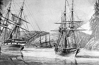
HMS Plumper was an 8-gun wooden screw sloop of the Royal Navy, the fifth and last ship to bear the name. Launched in 1848, she served three commissions, firstly on the West Indies and North American Station, then on the West Africa Station and finally in the Pacific Station. It was during her last commission as a survey ship that she left her most enduring legacy; in charting the west coast of British Columbia she left her name and those of her ship's company scattered across the charts of the region. She paid off for the last time in 1861 and was finally sold for breaking up in 1865.

The Gwa'Sala-Nakwaxda'xw Nations are a union of two Kwakwaka'wakw peoples in a band government based on northern Vancouver Island in British Columbia, Canada, whose main reserve community is near the town of Port Hardy in the Queen Charlotte Strait region of the Central Coast region of British Columbia, Canada. The band government is a member of the Kwakiutl District Council and, for treaty negotiation purposes, the Winalagalis Treaty Group which includes three other members of the Kwakiutl District Council.

Keats Island is an inhabited island located in Howe Sound near Vancouver, British Columbia. Around eighty people live on Keats Island year-round.

Bowyer Island is a small private island in Howe Sound. It comprises Kildare Estates, Bowyer Island Estates, and B and A Estates. It is located east of Bowen Island and Horseshoe Bay. BC Liberal politician, formerly Attorney-General of British Columbia, Geoff Plant is a seasonal resident.
Mudge Island is one of the Southern Gulf Islands in the Strait of Georgia, in British Columbia (BC), Canada. It lies between Gabriola Island and Vancouver Island, and is considered part of the De Courcy group of islands. It is about 0.8 km (0.50 mi) wide and 4 km (2.5 mi) long.
Gilford Island is an island in British Columbia, Canada, located between Tribune Channel and Knight Inlet. The island has an area of 382 square kilometres (147 sq mi). Turnour Island is to the south across Tribune Channel, the entrance to Thompson Sound to the east.
The Nazko First Nation is a First Nations government of the Dakelh people in the north-central Interior of British Columbia. Its reserves are located around the community of Nazko, British Columbia, which is 120 km west of Quesnel and southwest of Prince George.
Campbell Island is an island in the Canadian province of British Columbia, located west of Denny Island and north of Hunter Island, near Milbanke Sound. The Inside Passage waterways of Lama Passage and Seaforth Channel meet at the northern end of Campbell Island.
The Malaspina Peninsula is a peninsula in the northern Gulf of Georgia-Sunshine Coast region of British Columbia, Canada. It extends northwest from the town of Powell River, which lies near its isthmus, past the settlement of Lund, to Desolation Sound. This sound spans the opening of Toba Inlet, a fjord lying between Lund and the Discovery Islands to the west and northwest.
Bedwell Sound is a sound on the West Coast of Vancouver Island, British Columbia, Canada. It is located in the Clayoquot Sound region to the north of Meares Island and the resort community of Tofino. The Bedwell River, originally the Bear River and called Oinimitis in the Nuu-chah-nulth language, empties into and gets its current name from the Sound.
The Defence Islands are two small islands in Howe Sound, British Columbia, Canada, located northeast of Anvil Island and in the northern reaches of that sound near Porteau Cove. The easterly and smaller of the two comprises Defence Island Indian Reserve No. 28, 1.7 ha., the westerly comprises the Kwum Kwum Indian Reserve (unnumbered), 6.20 ha. Both are under the administration of the Squamish Nation.
Daniel Pender was a Royal Navy Staff Commander, later Captain, who surveyed the Coast of British Columbia aboard HMS Plumper, HMS Hecate and the Beaver from 1857 to 1870.
The Tseycum First Nation is a First Nations government located on Vancouver Island. In the 1850s they were signatories to the Douglas Treaties.

Bedwell Harbour is a settlement on South Pender Island in British Columbia, close to the Canada–US border. Bedwell Harbour is an official port of entry for sailors from the United States.
Port Browning, British Columbia, Canada is formed between North and South Pender Islands in the British Columbia Gulf Islands. There is a government dock and commercial marina at the head of the inlet. From Port Browning, Pender Canal leads to Bedwell Harbour. Port Browning also leads eastward to Plumper Sound.
Koksilah is a community located just southeast of the City of Duncan, British Columbia, Canada. Its name is derived, via that of the Koksilah River, from that of the Hwulqwselu people, one of the Hunqinum-speaking peoples of the area today organized as the Cowichan Tribes and government.
Scott Cove is a locality on the west side of Gilford Island in the Queen Charlotte Strait region of the Central Coast of British Columbia, Canada, located at the cove of the same name.


