The term Batlôkwa refers to several Kgatla communities that reside in Lesotho and South Africa.
The diverse culture of Ivory Coast, a coastal West African country bordered by Ghana, Liberia, Mali, Burkina Faso, and Guinea, is exemplified by a multitude of ethnic groups, events, festivals, music, and art.
The Upper East Region is located in northern Ghana and is the third smallest of the 16 administrative regions in Ghana. It occupies a total land surface of 8,842 square kilometers or 2.7 per cent of the total land area of Ghana. The Upper East regional capital is Bolgatanga, sometimes referred to as Bolga. Other major towns in the region include Navrongo, Paga, Sandema, Bawku, and Zebilla.
The Idomas are people that primarily inhabit the lower western areas of Benue State, Nigeria, and some of them can be found in Taraba State, Cross Rivers State, Enugu State, Kogi State and Nasarawa State in Nigeria. The Idoma language is classified in the Akweya subgroup of the Idomoid languages of the Volta–Niger family, which include Igede, Alago, Agatu, Etulo, Ete, Akweya (Akpa) and Yala languages of Benue, Nasarawa, Kogi, Enugu, and Northern Cross River states. The Akweya subgroup is closely related to the Yatye-Akpa sub-group. The bulk of the territory is inland, south of river Benue, some seventy-two kilometres east of its confluence with River Niger. The Idoma tribe are known to be 'warriors' and 'hunters' of class, but hospitable and peace-loving. The greater part of Idoma land remained largely unknown to the West until the 1920s, leaving much of the colourful traditional culture of the Idoma intact. The population of the Idomas is estimated to be about 3.5 million. The Idoma people have a traditional ruler called the Och'Idoma who is the head of the Idoma Area Traditional Council. This was introduced by the British. Each community has its own traditional chief such as the former Ad'Ogbadibo of Orokam, Late Chief D.E Enenche. The Palace of the Och'Idoma is located at Otukpo, Benue State. The present Och'Idoma, HRM, Elaigwu Odogbo John, the 5th Och'Idoma of the Idoma People was installed on the 30th of June, 2022 following the passing of his Predecessor HRH Agabaidu Elias Ikoyi Obekpa who ruled from 1996 to October 2021. Past Och'Idomas also include: HRH, Agabaidu Edwin Ogbu, who reigned from 1996 to 1997, HRH, Abraham Ajene Okpabi of Igede descent who ruled from 1960 to 1995 and HRH, Agabaidu Ogiri Oko whose reign took place between 1948 and 1959.
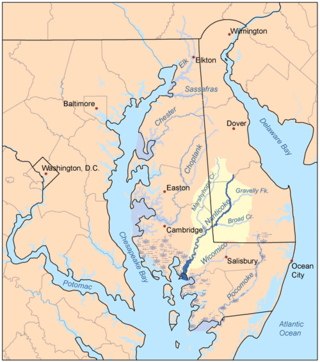
The Nanticoke people are a Native American Algonquian people, whose traditional homelands are in Chesapeake Bay and Delaware. Today they live in the Northeastern United States and Canada, especially Delaware; in Ontario; and in Oklahoma.
The Dan or Mano-Dan are a Mande ethnic group from northwestern Ivory Coast and neighbouring Liberia. There are approximately 700,000 members of the group and their largest settlement is Man, Ivory Coast. Neighboring peoples include the Krahn, Kpelle and Mano. They are officially known as Yacouba.

Ipele is a town in Owo Local Government in Ondo State, South-Western Nigeria.

The Nguni people are a linguistic cultural group that migrated to South Africa, made up of Bantu ethnic groups from central Africa, with offshoots in neighboring countries in Southern Africa. Swazi people live in both South Africa and Eswatini, while Ndebele people live in both South Africa and Zimbabwe.

Nangal Sirohi, famous for the painted Shekhavati Rajput architecture Havelis, is a village in Mahendragarh district in the Indian state of Haryana. It is 9.5 km from Mahendragarh towards Narnaul in South Haryana.
The Ohuhu clan of Umuahia north in Abia State Nigeria Igbo people, also referred to as Ohonhaw, form a unique community of people in Umuahia, Abia state, Nigeria, consisting of several Autonomous Communities including Umukabia, Ohiya, Isingwu, Ofeme, Afugiri, Nkwoegwu, Umuawa, Umudiawa, Akpahia, Umuagu, Amaogugu, Umule-Eke-Okwuru, Umuhu-Okigha, Amaogwugwu called Eziama/ Amaudo in Ohuhu etc. Ohuhu was formerly known as Umuhu-na-Okaiuga, or better-known as Ohu-ahia-na-otu. Until 1949, the Umuopara clan used to be part of Ohuhu before they were carved out politically.

The Oron people are a multi-ethnic tribal grouping that make up the Akpakip Oro or Oron Nation. The Oron people (Örö) are located primarily in southern Nigeria in the riverine area of Akwa Ibom State and Cross River State and in Cameroon. Akpakip Oro are regarded as an ancient warrior people, speaking the Oron (Oro) language which is in the Cross River language family of the Benue–Congo languages. They are ancestrally related to the Efik people of the Cross River State, the Ibeno and Eastern Obolo in Akwa Ibom, the Andoni people in Rivers State, Ohafia in Abia State and the Balondo-ba-Konja in the Congo.
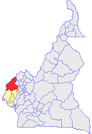
Manyu is a division of the Southwest Region in Cameroon. The division covers an area of 9,565 km2 and as of 2005 had a total population of 181,039. The capital of the division is Mamfe.

The Coast Veddas, by self-designation, form a social group within the minority Sri Lankan Tamil ethnic group of the Eastern province of Sri Lanka. They are primarily found in small coastal villages from the eastern township of Trincomalee to Batticalao. Nevertheless, they also inhabit a few villages south of Batticalao as well. They make a living by fishing, slash and burn agriculture, paddy cultivation of rice, basket weaving for market and occasional wage labor. Anthropologists consider them to be partly descended from the indigenous Vedda people, as well as local Tamils. Residents of the Eastern province consider their Vedar neighbors to have been part of the local social structure from earliest times, whereas some Vedar elders believe that their ancestors may have migrated from the interior at some time in the past.
Ikoro-Ekiti is a town in the Ijero Local Government area of Ekiti State, south west Nigeria. It is also known as Eso Obe and is one of the oldest towns in Ekiti land. It was politically subsumed under the paramountry of Ijero, the Ijero Native Authority, the Ijero District, which has now become Ijero Local Government. Historic facts have it that, the present Ikoro-Ekiti is a conglomeration of sixteen settlements dating from the eighteenth century and originally settled by Olugona who gave Oluse of Isedo the functional powers due to his old age. Today, Ikoro-Ekiti, has two main Quarters: Oke-Oja and Odokoro with many streets, is a large town noted for production of cocoa, kola nut, timber and palm fruit. In fact, the town was a major contributor of the products to the socio-economic development of the old western Nigeria. Ikoro-Ekiti has modern facilities and the people have a high degree of hospitality. Moreover, the people are very resourceful, with many of the indigene holding positions in many areas of human endeavors across the globe. The traditional head of the town is called the Olukoro of Ikoro-Ekiti, a first class king in the Ekiti State Traditional Council. The present king, His Royal Majesty Oba Olanrewaju Adebanji Adeleye is the 15th Olukoro. He ascended the throne in 2008 after twenty four years of an interregnum in the kingship.
Okpara Inland is a community located in the Ethiope East local government area of Delta State Nigeria. This community is a progeny of the Agbon Kingdom. Local history has it that it is the first son of Agbon whose traditional seat of leadership is Isiokolo. The previous king of the community, now deceased, HRM Chamberlain Oyibocha Orovwuje, Ogurimerime Okpara I, used this community as his centre of leadership bypassing the ancient satellite of Isiokolo.
Amawom is a town in Oboro, Ikwuano Local Government Area of Abia State, Nigeria. The name is derived from two words; Ama meaning location and Awom meaning farm. Amawom is believed to have been discovered in the 18th century. Awom Oboro and Ibeuzo Ukwu are the autonomous communities of Amawom. English and Igbo are the languages spoken in the town.
Mmaku is a town in the Awgu local government area of Enugu State, Nigeria. The name Mmaku means "Welcomer" or "Embracer". Another derivation comes from the English language, and it means "beauty of wealth."
Ilara-Mokin is located in a central part of Ifedore local government of Ondo State, Nigeria. Ilara-Mokin is about 12 km from Ondo state capital, and has Ipogun, Ipinsa, Ikota, Ibule-Soro and Ero as neighbouring towns.

Babulo(Babolu) is a settlement in East Timor and a Suco in the Uato-Lari Administrative Post. The Suco is one of the ethnic centers of the Naueti, and is also inhabited by the Makasae, an ethnic minority in the region. The different groups and clans are tightly connected through an ancient social structure which still has a big impact on their society today.

Ilara Yewa is a Nigerian town in the west of Ogun State, Nigeria about 91 kilometers northwest of Abeokuta. It lies on the border between Nigeria and Benin. Its elevation is 600 feet above sea level. Ilara Yewa is about 50 kilometres by road from Ketu, a major trading town in Benin. The second-largest settlement, Ilara, merges into Ilara.