
Juan Bautista de Anza was born in the Spanish province of New Navarre in Viceroyalty of New Spain. Of Basque descent, he served as an expeditionary leader, military officer, and politician primarily in California and New Mexico under the Spanish Empire. He is credited as one of the founding fathers of Spanish California and served as an official within New Spain as Governor of the Province of New Mexico.

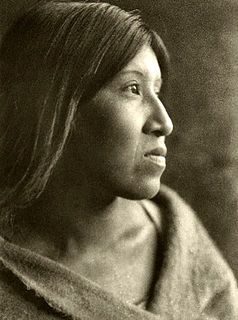
The Quechan are an aboriginal American tribe who live on the Fort Yuma Indian Reservation on the lower Colorado River in Arizona and California just north of the Mexican border. Despite their name, they are not related to the Quechua people of the Andes. Members are enrolled into the Quechan Tribe of the Fort Yuma Indian Reservation. The federally recognized Quechan tribe's main office is located in Winterhaven, California. Its operations and the majority of its reservation land are located in California, United States.

Gila Bend, founded in 1872, is a town in Maricopa County, Arizona, United States. The town is named for an approximately 90-degree bend in the Gila River, which is near the community's current location. According to the 2010 census, the population of the town is 1,922.

The Ramona Outdoor Play, formerly known as The Ramona Pageant, is an outdoor play staged annually in Hemet, California since 1923. It is based on the 1884 novel Ramona by Helen Hunt Jackson.

The Pima are a group of Native Americans living in an area consisting of what is now central and southern Arizona, as well as northwestern Mexico in the states of Sonora and Chihuahua. The majority population of the surviving two bands of the Akimel O'odham are based in two reservations: the Keli Akimel Oʼotham on the Gila River Indian Community (GRIC) and the On'k Akimel O'odham on the Salt River Pima-Maricopa Indian Community (SRPMIC).
The Cahuilla, also known as ʔívil̃uqaletem or Ivilyuqaletem, are a Native American people of the various tribes of the Cahuilla Nation, living in the inland areas of southern California. Their original territory included an area of about 2,400 square miles (6,200 km2). The traditional Cahuilla territory was near the geographic center of Southern California. It was bounded to the north by the San Bernardino Mountains, to the south by Borrego Springs and the Chocolate Mountains, to the east by the Colorado Desert, and to the west by the San Jacinto Plain and the eastern slopes of the Palomar Mountains.

Francisco Hermenegildo Tomás Garcés, O.F.M., was a Spanish Franciscan friar who served as a missionary and explorer in the colonial Viceroyalty of New Spain. He explored much of the southwestern region of North America, including present day Sonora and Baja California in Mexico, and the U.S. states of Arizona and California. He was killed along with his companion friars during an uprising by the Native American population, and they have been declared martyrs for the faith by the Catholic Church. The cause for his canonization was opened by the Church.
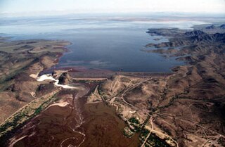
The Painted Rock Dam is an earthfill embankment dam located west of Gila Bend, Arizona. It is primarily used for flood control purposes.

The Juan Bautista de Anza National Historic Trail is a 1,210-mile (1,950 km) National Park Service unit in the United States National Historic Trail and National Millennium Trail programs. The trail route extends from Nogales on the U.S.-Mexico border in Arizona, through the California desert and coastal areas in Southern California and the Central Coast region to San Francisco.

Tubac Presidio State Historic Park, located in Tubac, Arizona, USA, preserves the ruins of the Presidio San Ignacio de Tubac and various other buildings, thereby presenting a timeline of human settlement in this Southern Arizona town. The park contains a museum, a number of historic sites, an underground archeology exhibit displaying the excavated foundations of the Tubac Presidio, and a picnic area. Various cultural events are held on-site throughout the year, including Anza Days (October), Los Tubaqueños living history presentations, archeological tours, and nature walks. Until recently, the park was administered by Arizona State Parks and was the first park in the Arizona state park system. As a result of budget cutbacks, the Tubac Presidio was scheduled to be closed in 2010, but was rescued by local residents and the Tubac Historical Society. It is now operated by The Friends of the Presidio and staffed with dedicated volunteers.For even more information about Tubac Presidio State Historic Park, visit their official website or join the discussion on Facebook!

Yuma Crossing is a site in Arizona and California that is significant for its association with transportation and communication across the Colorado River. It connected New Spain and Las Californias in the Spanish Colonial period in and also during the Western expansion of the United States. Features of the Arizona side include the Yuma Quartermaster Depot and Yuma Territorial Prison. Features on the California Side include Fort Yuma, which protected the area from 1850 to 1885.

The Presidio of San Ignacio de Túbac or Fort Tubac was a Spanish built fortress. The fortification was established by the Spanish Army in 1752 at the site of present-day Tubac, Arizona. Its ruins are preserved in the Tubac Presidio State Historic Park.

Pilot Knob is a peak in Imperial County, California. Pilot Knob is located 8 miles (13 km) southeast of Ogilby, It rises to an elevation of 876 feet (267 m). Pilot Knob is a rocky landform, geologically a Volcanic plug, west of Yuma, Arizona–Winterhaven, California; it is connected to the Cargo Muchacho Mountains, the central portion of the mountains being about 7 miles (11 km) north. Pilot Knob was named for its prominence as a landmark for riverboat traffic in the 19th-20th centuries on the Colorado River which borders Winterhaven–Yuma. Pilot Knob is an Area of Critical Environmental Concern administered by the Bureau of Land Management.
The Soboba Band of Luiseño Indians is a federally recognized tribe of Luiseño people, headquartered in Riverside County, California. On June 18, 1883, the Soboba Reservation was established by the United States government in San Jacinto. There are five other federally recognized tribes of Luiseño people in southern California.

The San Jacinto Valley is a valley located in Riverside County, in Southern California, in the Inland Empire. The valley is located at the base of the San Jacinto Mountains in the east and Santa Rosa Hills to the south with the San Gorgonio Pass to the north. The average elevation is 1,500 feet (460 m), with the highest points in the foothills south of Hemet and the western slopes of the San Jacinto Mountains. It is home to two cities, Hemet and San Jacinto, and several unincorporated communities. The valley has a combined population of nearly 170,000 residents, including more than 130,000 residents within the city limits of Hemet and San Jacinto. The valley is also where the story and play "Ramona" was set; the story was written after author Helen Hunt Jackson visited the valley in the 1880s. The valley is also known for being an area of agriculture, which has given way to more urbanized development.
Martha McLean – Anza Narrows is a 40-acre regional park located along the Santa Ana River in Riverside, California, United States. The park is operated by the City of Riverside - Parks Recreation and Community Services Department. A plaque in the northwest corner of the park marks the point at which the Juan Bautista de Anza party, the first Europeans to traverse the Riverside area, crossed the river in 1774 and again in 1776.
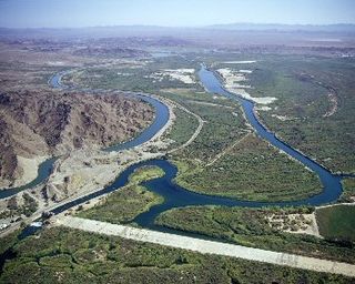
The Yuma Project is a U.S. Bureau of Reclamation project built to irrigate over 68,000 acres (280 km2) of land in Yuma County, Arizona and parts of Imperial County, California. The project is designed to exploit year-round farming conditions and water from the Colorado River. It consists of the Laguna Diversion Dam, pumping plants, a power plant, a 53-mile (85 km) system of canals, 218 miles (351 km) of lateral canals, levees and drains. The project began in 1903 and the majority of the work was completed by 1915. It was the first dam and reclamation project on the Colorado River and workers had to overcome many natural and logistical obstacles to build and maintain it. The Laguna Diversion Dam was replaced by the Imperial Dam as the Project's water source between 1941 and 1948. Today, it serves 275 farms and over 94,000 people.

Southern Emigrant Trail, also known as the Gila Trail, the Kearny Trail, Southern Trail and the Butterfield Stage Trail, was a major land route for immigration into California from the eastern United States that followed the Santa Fe Trail to New Mexico during the California Gold Rush. Unlike the more northern routes, pioneer wagons could travel year round, mountain passes not being blocked by snows, however it had the disadvantage of summer heat and lack of water in the desert regions through which it passed in New Mexico Territory and the Colorado Desert of California. Subsequently, it was a route of travel and commerce between the eastern United States and California. Many herds of cattle and sheep were driven along this route and it was followed by the San Antonio-San Diego Mail Line in 1857-1858 and then the Butterfield Overland Mail from 1858 - 1861.
Pima Villages, sometimes mistakenly called the Pimos Villages in the 19th century, were the Akimel O’odham (Pima) and Pee-Posh (Maricopa) villages in what is now the Gila River Indian Community in Pinal County, Arizona. First, recorded by Spanish explorers in the late 17th century as living on the south side of the Gila River, they were included in the Viceroyalty of New Spain, then in Provincias of Sonora, Ostimuri y Sinaloa or New Navarre to 1823. Then from 1824 to 1830, they were part of the Estado de Occidente of Mexico and from September 1830 they were part of the state of Sonora. These were the Pima villages encountered by American fur trappers, traders, soldiers and travelers along the middle Gila River from 1830s into the later 19th century. The Mexican Cession following the Mexican American War left them part of Mexico. The 1853 Gadsden Purchase made their lands part of the United States, Territory of New Mexico. During the American Civil War they became part of the Territory of Arizona.
Jaeger's Ferry was a major river ferry at the Yuma Crossing of the Colorado River in the 1850s until 1862, 1 mile below Fort Yuma.

