
The Haute Route, is the name given to a route undertaken on foot or by ski touring between the Mont Blanc in Chamonix, France, and the Matterhorn, in Zermatt, Switzerland.

The Grand Combin is a mountain massif in the western Pennine Alps in the canton of Valais. At a height of 4,314 metres (14,154 ft) the summit of Combin de Grafeneire is one of the highest peaks in the Alps and the second most prominent of the Pennine Alps. The Grand Combin is also a large glaciated massif consisting of several summits, among which three are above 4000 metres. The highest part of the massif is wholly in Switzerland, although the border with Italy lies a few kilometres south.

Verbier is a village located in south-western Switzerland in the canton of Valais. It is a holiday resort and ski area in the Swiss Alps and is recognised as one of the premier off-piste resorts in the world. Some areas are covered with snow all year. Skiers have settled in the Verbier area in order to take advantage of the steep slopes, varied conditions, and resort culture.

The Dent du Géant is a mountain in the Mont Blanc massif in France and Italy.

The Vanoise massif is a mountain range of the Graian Alps, located in the Western Alps. After the Mont Blanc Massif and the Massif des Écrins it is the third highest massif in France, reaching a height of 3,885 m at the summit of Grande Casse. It lies between Tarentaise Valley to the north and the Maurienne valley in the south. The range is the site of France's first National Park in 1963, the Vanoise National Park. The ski resorts of Tignes and Val-d'Isère and the 2,770-meter-high Col de l'Iseran are located in the eastern part of the range.
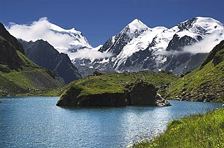
The Petit Combin is a mountain of the Swiss Pennine Alps, located between the valleys of Entremont and Bagnes in the canton of Valais. It belongs to the Grand Combin massif.

La Ruinette is a mountain of the Swiss Pennine Alps, overlooking the Lake of Mauvoisin in the canton of Valais. With an altitude of 3,875 metres above sea level, it is the highest summit between the Grand Combin and the Dent Blanche. La Ruinette lies close to the better known Mont Blanc de Cheilon which has almost the same height.
The Combin de Corbassière is a mountain in the Pennine Alps, located south of Fionnay in the canton of Valais. It is part of the Grand Combin massif and lies on the west side of the Corbassière Glacier. It is also a main source for sparkling water.
The Combin de Boveire is a mountain of the Pennine Alps, located in the Grand Combin massif in Valais. It lies between the Boveire Glacier and the Corbassière Glacier.
The Grande Tête de By is a mountain of the Pennine Alps, located on the border between Italy and Switzerland. With a height of 3,587 metres above sea level, it is the highest summit on the Italian side of the Grand Combin massif.
The Pointe Allobrogia is a mountain of the Mont Blanc massif, overlooking the Col Ferret on the border between Italy and Switzerland. It lies at the southern end of the range south-east of Mont Dolent.
The Pointe Ronde is a mountain of the Mont Blanc massif, overlooking Trient in the canton of Valais. It lies near the northern end of the Arête de la Lys, the ridge descending in a north-westerly direction from the Génépi towards the Col de la Forclaz.
The Pointe des Plines is a minor peak on the east edge of the Mont Blanc massif, close to the Aiguille Dorees, and overlooking the Saleina Glacier in the canton of Valais.

The Six Blanc is a mountain of the Swiss Pennine Alps, overlooking Orsières in the canton of Valais. It lies at the northern end of the chain separating the valley of Entremont from the valley of Bagnes, culminating at the Grand Combin.
The Grande Pointe des Planereuses is a mountain of the Mont Blanc massif, located west of Praz de Fort in the canton of Valais, Switzerland. It lies on the range south of the Saleina Glacier.
The Grande Aiguille is a mountain of the Swiss Pennine Alps, situated near Bourg Saint Pierre in the canton of Valais. With an elevation of 3,682 metres above sea level, it the culminating point of the ridge named Les Maisons Blanches that lies west of the Corbassière Glacier, in the Grand Combin massif.
The Bornes Massif is a mountainous massif in the north French Prealps in the département of Haute-Savoie. It has 20 peaks higher than 2000 m and is a popular destination for winter sports. The Massif is the source of the celebrated cheese Reblochon.
The Tavé des Chasseurs is a mountain of the Swiss Pennine Alps, located south of Fionnay in the canton of Valais. It belongs to the Grand Combin massif and lies east of the Corbassière Glacier.

Valpelline is one of the side valleys of the Aosta Valley in north-west Italy. It shares its name with one of the communes within its territory (Valpelline).

Val de Bagnes, also called the Vallée de Bagnes is a valley located in the Entremont District in the Canton of Valais of Switzerland.
