
Chamonix-Mont-Blanc, more commonly known as Chamonix, is a commune in the Haute-Savoie department in the Auvergne-Rhône-Alpes region of southeastern France. It was the site of the first Winter Olympics in 1924. In 2017, it had a population of 8,611.

Raymond Lambert was a Swiss mountaineer who together with Sherpa Tenzing Norgay reached an altitude of 8611 metres of Mount Everest, as part of a Swiss Expedition in May 1952. At the time it was the highest point that a climber had ever reached. There was a second Swiss expedition in autumn 1952, but a party including Lambert and Tenzing was forced to turn back at a slightly lower point. The following year Tenzing returned with Edmund Hillary to reach the summit on 29 May 1953.

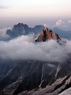
The Grandes Jorasses is a mountain in the Mont Blanc massif, on the boundary between Haute-Savoie in France and Aosta Valley in Italy.
The Aiguille du Midi is a 3,842-metre-tall (12,605 ft) mountain in the Mont Blanc massif within the French Alps. It is a popular tourist destination and can be directly accessed by cable car from Chamonix that takes visitors close to Mont Blanc.

The Western Cwm is a broad, flat, gently undulating glacial valley basin terminating at the foot of the Lhotse Face of Mount Everest. It was named by George Mallory when he saw it in 1921 as part of the British Reconnaissance Expedition that was the first to explore the upper sections of Everest, searching for routes for future summit attempts; Cwm is Welsh for "valley".

Mont Pelvoux is a mountain in the Massif des Écrins in the French Alps. It stands 3,946 m (12,946 ft) in elevation.

The Aravis is a mountain range in Savoie and Haute-Savoie, eastern France. It is part of the French Prealps, a lower chain of mountain ranges west of the main chain of the Alps. Its highest summit is the Pointe Percée, at 2753m. The orientation of the Aravis is north-south, and it stretches from Cluses in the north, to Ugine in the south. The Bornes massif, sometimes considered part of the Aravis, lies to its west. The Aravis is separated from the Chablais mountains in the north-east by the Arve river valley, and from the Graian Alps in the south-east by the Arly river valley.

The Bauges Mountains is a mountain range in Auvergne-Rhône-Alpes, Eastern France, stretching from the city of Annecy, Haute-Savoie to the city of Chambéry, Savoie, which is part of the French Prealps.

Saint-Julien-en-Genevois is a subprefecture of the Haute-Savoie department in the Auvergne-Rhône-Alpes region in Eastern France. In 2018, the commune had a population of 15,509.

The arrondissement of Saint-Julien-en-Genevois is an arrondissement of France in the Haute-Savoie department in the Auvergne-Rhône-Alpes region. It has 72 communes. Its population is 186,343 (2016), and its area is 660.3 km2 (254.9 sq mi).

The Vanoise massif is a mountain range of the Graian Alps, located in the Western Alps. After the Mont Blanc Massif and the Massif des Écrins it is the third highest massif in France, reaching a height of 3,885 m at the summit of Grande Casse. It lies between Tarentaise Valley to the north and the Maurienne valley in the south. The range is the site of France's first National Park in 1963, the Vanoise National Park. The ski resorts of Tignes and Val-d'Isère and the 2,770-meter-high Col de l'Iseran are located in the eastern part of the range.

Michel Auguste Croz was a French mountain guide and the first ascentionist of many mountains in the western Alps during the golden age of alpinism. He is chiefly remembered for his death on the first ascent of the Matterhorn and for his climbing partnership with Edward Whymper.

Clermont en Genevois is a commune in the Haute-Savoie department in the Auvergne-Rhône-Alpes region in south-eastern France.

Le Reposoir is a commune in the Haute-Savoie department in the Auvergne-Rhône-Alpes region in south-eastern France.

The Aiguille de la Tsa is a mountain of the Swiss Pennine Alps, overlooking Arolla in the canton of Valais. It lies on the range culminating at the Dent de Perroc, between the valley of Arolla and the Mont Miné Glacier.
The Pointe des Plines is a minor peak on the east edge of the Mont Blanc massif, close to the Aiguille Dorees, and overlooking the Saleina Glacier in the canton of Valais.

The Pointe des Ecandies is a mountain of the Mont Blanc Massif, located between Trient and Champex in the canton of Valais. It is located north of the Pointe d'Orny and east of the Trient Glacier.
The Bornes Massif is a mountainous massif in the north French Prealps in the département of Haute-Savoie. It has 20 peaks higher than 2000 m and is a popular destination for winter sports. The Massif is the source of the celebrated cheese Reblochon.
The Geneva Spur, named Eperon des Genevois and has also been called the Saddle Rib is a geological feature on Mount Everest—it is a large rock buttress near the summits of Everest and Lhotse. The Geneva spur is above Camp III and the Yellow Band, but before Camp IV and South Col. It is a spur near the south col. A related formation is the saddle between the peaks of Mount Everest and Lhotse.

The Pointe des Mossettes is a mountain of the Chablais Alps, overlooking Les Crosets in the Swiss canton of Valais. The French border runs west of the summit on a straight line, although the mountain lies on the main watershed between the Dranse river basin and the Val d'Illiez.
