
A geographic information system (GIS) consists of integrated computer hardware and software that store, manage, analyze, edit, output, and visualize geographic data. Much of this often happens within a spatial database, however, this is not essential to meet the definition of a GIS. In a broader sense, one may consider such a system also to include human users and support staff, procedures and workflows, the body of knowledge of relevant concepts and methods, and institutional organizations.

A digital elevation model (DEM) or digital surface model (DSM) is a 3D computer graphics representation of elevation data to represent terrain or overlaying objects, commonly of a planet, moon, or asteroid. A "global DEM" refers to a discrete global grid. DEMs are used often in geographic information systems (GIS), and are the most common basis for digitally produced relief maps. A digital terrain model (DTM) represents specifically the ground surface while DEM and DSM may represent tree top canopy or building roofs.

Topography is the study of the forms and features of land surfaces. The topography of an area may refer to the land forms and features themselves, or a description or depiction in maps.

Remote sensing is the acquisition of information about an object or phenomenon without making physical contact with the object, in contrast to in situ or on-site observation. The term is applied especially to acquiring information about Earth and other planets. Remote sensing is used in numerous fields, including geophysics, geography, land surveying and most Earth science disciplines ; it also has military, intelligence, commercial, economic, planning, and humanitarian applications, among others.

The Landsat program is the longest-running enterprise for acquisition of satellite imagery of Earth. It is a joint NASA / USGS program. On 23 July 1972, the Earth Resources Technology Satellite was launched. This was eventually renamed to Landsat 1 in 1975. The most recent, Landsat 9, was launched on 27 September 2021.
An orthophoto, orthophotograph, orthoimage or orthoimagery is an aerial photograph or satellite imagery geometrically corrected ("orthorectified") such that the scale is uniform: the photo or image follows a given map projection. Unlike an uncorrected aerial photograph, an orthophoto can be used to measure true distances, because it is an accurate representation of the Earth's surface, having been adjusted for topographic relief, lens distortion, and camera tilt.

The Byrd Polar and Climate Research Center (BPCRC) is a polar, alpine, and climate research center at The Ohio State University founded in 1960.
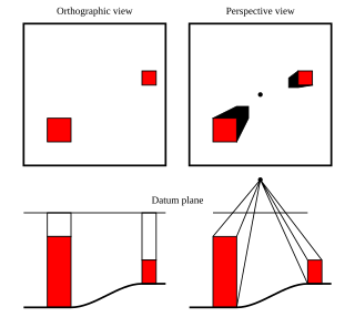
Geomorphometry, or geomorphometrics, is the science and practice of measuring the characteristics of terrain, the shape of the surface of the Earth, and the effects of this surface form on human and natural geography. It gathers various mathematical, statistical and image processing techniques that can be used to quantify morphological, hydrological, ecological and other aspects of a land surface. Common synonyms for geomorphometry are geomorphological analysis, terrain morphometry, terrain analysis, and land surface analysis. Geomorphometrics is the discipline based on the computational measures of the geometry, topography and shape of the Earth's horizons, and their temporal change. This is a major component of geographic information systems (GIS) and other software tools for spatial analysis.

The Geospatial Data Abstraction Library (GDAL) is a computer software library for reading and writing raster and vector geospatial data formats, and is released under the permissive X/MIT style free software license by the Open Source Geospatial Foundation. As a library, it presents a single abstract data model to the calling application for all supported formats. It may also be built with a variety of useful command line interface utilities for data translation and processing. Projections and transformations are supported by the PROJ library.
SOCET SET is a software application that performs functions related to photogrammetry. It is developed and published by BAE Systems. SOCET SET was among the first commercial digital photogrammetry software programs. Prior to the development of digital solutions, photogrammetry programs were primarily analog or custom systems built for government agencies.
The Barrow Area Information Database (BAID) is designed to support Arctic science with a special focus on the research hubs of Barrow, Atqasuk, and Ivotuk on the North Slope of Alaska.
Circumarctic Environmental Observatories Network (CEON) is a network of terrestrial and freshwater observation platforms, science experts and network partners promoting the collection and dissemination of environmental data from the Arctic. CEON observation platforms include land and freshwater observatories, research infrastructures, former research sites where retrospective analyses are being or can be undertaken, data and image archive centers and community monitoring programs.
Geographic Information Systems (GIS) are an increasingly important component of business, healthcare, security, government, trade, media, transportation and tourism industries and operations in China. GIS software is playing an increasing role in the way Chinese companies analyze and manage business operations.
NPA Satellite Mapping is the longest-established satellite mapping specialist in Europe, with expertise in geoscience applications of earth observation and remote sensing. In addition to processing and distributing data from a variety of optical and radar satellites, NPA specialises in added-value and derived products, providing validation and interpretation of satellite-based imagery.

The Remote Sensing Center (RSC) at the Naval Postgraduate School was established to bring together a range of capabilities and expertise to address problems of military and intelligence importance, as well as environmental and civil concerns. It is specialized in a variety of remote sensing technologies designed to enable people to look beyond the range of human vision in range or in spectral perception.
Mullins Valley is a four mile long valley located at 5,400 ft elevation in the McMurdo Dry Valleys. It is one of the few dry valleys in the world to contain rock glaciers. US Antarctic Program (USAP) research has dated the subsurface ice in Mullins Valley at 4 million years old making it among the oldest ice on earth. United States Antarctic Program (USAP) research has also shown the rock glaciers in the valley to be analogous to the Arsia Mons region on Mars. Named for Jerry L. Mullins, Physical Scientist, Director, Polar Programs, Antarctic and Arctic Program for United States Geological Survey (USGS), National Science Foundation Antarctic geophysical research, and U.S Scientific Committee (SCAR) delegate to SCAR SCAGI committee. Appointed by the National Academy of Sciences, Polar Research Board. His was responsible for Antarctic field research in the Transantarctic Mountains, McMurdo Dry Valleys, Shackleton Mountains, Beardmore Mountains, Antarctic Peninsula, Mount Siple, Amundsen-Scott South Pole station and at deep field research locations in West Antarctica. His program conducted research in the disciplines of global positioning systems, geodesy, crustal motion, glacial geophysics, airborne geospatial systems, airborne geophysics, seismology, light radar (lidar), topographic mapping and he managed the USGS South Pole winter-over program from 1989 to 1994. He was appointed by the National Academy of Sciences, Polar Research Board as a US delegate to the Scientific Committee on Antarctic Research Geosciences Standing Scientific Group from 1995–July 2012 and was appointed as a member of the Advisory Committee on Antarctic Names in 1994. Mullins Valley appears in the Antarctic research literature, on the maps from the British expedition of Captain Scott and in aerial photographs from the United States expedition Operation Highjump by Admiral Byrd. Mullins Valley, Mullins Lake, Mullins Glacier, and Mullins Geodetic Station, Antarctica are named for United States polar explorer and researcher Jerry L. Mullins.

Operation IceBridge is an ongoing NASA mission to monitor changes in polar ice. It is an airborne follow-on mission to the ICESat satellite, continuing until after the ICESat-2 mission launch in September 2018.

Dropla Gap is the flat, ice-covered saddle of elevation 1073 m in north-central Sentinel Range in Ellsworth Mountains, Antarctica, extending 1.35 km to link Maglenik Heights to the west and Barnes Ridge to the east. It is part of the glacial divide between Young Glacier to the north and Arapya Glacier to the south.
Burcu Özsoy is a Turkish scientist who works with sea ice remote sensing in Antarctica. Özsoy is head of the first Turkish polar research center, ITU PolReC.

Remote sensing in geology is remote sensing used in the geological sciences as a data acquisition method complementary to field observation, because it allows mapping of geological characteristics of regions without physical contact with the areas being explored. About one-fourth of the Earth's total surface area is exposed land where information is ready to be extracted from detailed earth observation via remote sensing. Remote sensing is conducted via detection of electromagnetic radiation by sensors. The radiation can be naturally sourced, or produced by machines and reflected off of the Earth surface. The electromagnetic radiation acts as an information carrier for two main variables. First, the intensities of reflectance at different wavelengths are detected, and plotted on a spectral reflectance curve. This spectral fingerprint is governed by the physio-chemical properties of the surface of the target object and therefore helps mineral identification and hence geological mapping, for example by hyperspectral imaging. Second, the two-way travel time of radiation from and back to the sensor can calculate the distance in active remote sensing systems, for example, Interferometric synthetic-aperture radar. This helps geomorphological studies of ground motion, and thus can illuminate deformations associated with landslides, earthquakes, etc.