
Dinkytown is a commercial district within the Marcy-Holmes neighborhood in Minneapolis, Minnesota. Centered at 14th Avenue Southeast and 4th Street Southeast, the district contains several city blocks occupied by various small businesses, restaurants, bars, and apartment buildings that house mostly University of Minnesota students. Dinkytown is along the North side of the University of Minnesota Twin Cities East Bank campus.

The University of Minnesota is a public land-grant research university in the Twin Cities of Minneapolis and Saint Paul, Minnesota, United States. The Twin Cities campus comprises locations in Minneapolis and Falcon Heights, a suburb of St. Paul, approximately 3 mi (4.8 km) apart.

The McNamara Alumni Center at the University of Minnesota's Twin Cities campus in Minneapolis, Minnesota. Designed by Antoine Predock, it is one of the more architecturally striking buildings in the Twin Cities. The building, opened in 2000, contains two main components: University office space and 10 meeting rooms for University and public use. The University owns the land, but the University of Minnesota Gateway Corporation, consisting of the U of M Foundation and U of M Alumni Association, owns the structure.
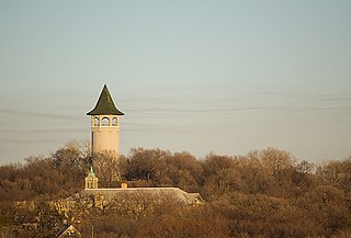
Prospect Park is a historic neighborhood within the University community of the U.S. city of Minneapolis, Minnesota. The area is bounded by the Mississippi River to the south, the City of Saint Paul, Minnesota to the east, the Burlington Northern railroad yard to the north, and the Stadium Village commercial district of the University of Minnesota to the west. The neighborhood is composed of several districts which include the East River Road area. The 1913 Prospect Park Water Tower is a landmark and neighborhood icon.

Minneapolis is officially defined by its city council as divided into 83 neighborhoods. The neighborhoods are historically grouped into 11 communities. Informally, there are city areas with colloquial labels. Residents may also group themselves by their city street suffixes, North, Northeast, South, Southeast, and Southwest.

University Avenue is a street that runs through both Minneapolis and Saint Paul, Minnesota. It begins near the Minnesota State Capitol in Saint Paul and extends westward into neighboring Minneapolis, where it passes the University of Minnesota, and then turns north to pass through several suburbs before its main portion ends in Blaine, Minnesota, although there are stretches of road designated as University Avenue that are north of the Blaine terminus, the final stretch ending near Andree, Minnesota. For many years, the road carried U.S. Highway 12 and U.S. Highway 52, and University Avenue is still a significant thoroughfare in the area.

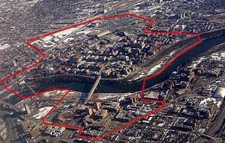
Cedar-Riverside, also referred to as the West Bank, or simply Riverside, is a neighborhood within Minneapolis, Minnesota. Its boundaries are the Mississippi River to the north and east, Interstate 94 to the south, and Hiawatha Avenue and Interstate 35W to the west. It has a longstanding tradition of cultural diversity and settlement, with a robust arts tradition.

Ridder Arena is an indoor ice rink at the University of Minnesota, and home to the Minnesota Golden Gophers women's ice hockey team. The arena is adjacent to the men's 3M Arena at Mariucci. It was completed in 2002, and includes the connected Baseline Tennis Center for the men's and women's tennis teams. It was the first facility in the United States built specifically for college women's ice hockey, and has hosted the NCAA Women's Frozen Four on four occasions. The arena is named for benefactors Robert Ridder and Kathleen Ridder.

Stadium Village station is a light rail station on the Green Line on the University of Minnesota campus in Minneapolis. Located in the Stadium Village area, it lies east of 23rd Avenue Southeast between University Avenue and 4th Street, across the road from Huntington Bank Stadium. East of the station, the rail line parallels the U of M Transitway until 29th Street SE, where it turns to enter Prospect Park station.

West Bank station is a light rail station along the Metro Green Line in Minneapolis. It serves the West Bank campus of the University of Minnesota, as well as the Cedar-Riverside neighborhood.

Downtown East is an official neighborhood in Minneapolis, Minnesota, United States. Within Downtown East is the Mill District, which contains former industrial buildings left over from the days when Minneapolis was the flour milling capital of the world. Many of these old mills and factories are being converted to housing, bringing a residential population to a neighborhood that beforehand didn't have many residents. Because of this, the Mill District in Downtown East is one of the fastest growing areas of the city.

Marcy-Holmes is a neighborhood in the University community of Minneapolis. The majority of the area is residential and sits upon a bluff overlooking the river and the city skyline. A small section of the neighborhood along the river is an industrial zone.

Como is a neighborhood within the University community of Minneapolis. It is sometimes referred to as Southeast Como, due to many of its streets ending in SE, and possibly to differentiate it from the Como neighborhood in neighboring Saint Paul. Its boundaries are East Hennepin Avenue to the north, 33rd Avenue Southeast to the east, the Southeast Industrial Area to the south, and Interstate 35W to the west.
Washington Avenue is a major thoroughfare in Minneapolis, Minnesota, United States. Starting north of Lowry Avenue, North Washington Avenue runs straight south, with Interstate 94 running alongside it until just south of West Broadway, when the freeway turns to the west. The street continues running straight until just south of Plymouth Avenue, where it turns in a southeasterly direction heading for Downtown Minneapolis. It forms the main thoroughfare through the Warehouse District.

The Mill District is a neighborhood within Minneapolis, Minnesota, United States, and a part of the larger Downtown East neighborhood. The neighborhood contains several former flour mills left over from the days when Minneapolis was the flour milling capital of the world. With almost none of the mills still active, a number of these have been converted into condominiums leading to a revitalization of the neighborhood.
University is a neighborhood within the greater University community in Minneapolis, Minnesota. It is almost completely occupied by the Minneapolis campus of the University of Minnesota, hence the name. It is located entirely within Minneapolis City Council Ward 2, represented by Robin Wonsley.

Frogtown is a neighborhood in Saint Paul in the U.S. state of Minnesota. Built around University Avenue, the Thomas-Dale neighborhood is colloquially known as Frogtown. Historically, Frogtown was a subsection of the current Thomas-Dale neighborhood. It is bordered by University Avenue on the south, the Burlington Northern Railroad tracks to the north, Lexington Parkway on the west and Rice Street on the east.

Marshall-University High School was a public junior high and high school serving grades 6–12 in Minneapolis, Minnesota.

WaHu Student Apartments is a luxury residential apartment building located in Minneapolis, Minnesota. It was first announced in 2012 with intent to cater to the campus population of the nearby University of Minnesota. The complex comprises 327 residential units within three apartment towers. It also contains designated retail space, currently leased by tenants such as Bank of America, Blaze Pizza, and local restaurants.
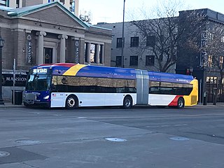
The Metro E Line is a planned bus rapid transit route in Minneapolis, Saint Paul, and Edina. The route will operate from Southdale Center Transit Center in Edina, Minnesota to Westgate station in Saint Paul. Running mostly on France Avenue, Hennepin Avenue, and University Avenue, the line will serve major destinations such as Southdale Center, Fairview Hospital, 50th & France, Linden Hills, Uptown, Minneapolis Sculpture Garden, Downtown Minneapolis, Dinkytown, the University of Minnesota, and Prospect Park. The route will have "train-like" features to speed up service and improve reliability, such as signal priority, bus lanes, all-door boarding, further stop spacing, and specialized vehicles. In 2019 planning and design were underway, with construction slated for 2023 and operations beginning a year later but that timeline has been moved back. The E Line would largely replace Route 6 which carries 9,000 trips each weekday. The project was fully funded with $60 million by the state of Minnesota in 2021 and is expected to open in 2025.


