Waite Park, Minneapolis

Last updated
Waite Park
MinneapolisWaiteParkNeighborhood.PNG
Location of Waite Park within the U.S. city of Minneapolis
Country United States
State Minnesota
County Hennepin
City Minneapolis
Community Northeast
Area
[1]
  Total0.88 sq mi (2.3 km2)
Population
 (2020) [2]
  Total5,550
  Density6,300/sq mi (2,400/km2)
Time zone UTC-6 (CST)
  Summer (DST) UTC-5 (CDT)
ZIP code
55418, 55421
Area code 612
Historical population
CensusPop.Note
1980 6,192
1990 5,707−7.8%
2000 5,205−8.8%
2010 5,2440.7%
2020 5,5505.8%

Waite Park is a neighborhood in the Northeast community in Minneapolis, Minnesota. Its boundaries are 37th Avenue NE to the north, NE Stinson Boulevard to the East, Saint Anthony Parkway to the south, and NE Central Avenue to the west. It is the furthest northeast neighborhood within Minneapolis. The neighborhood is within Minneapolis's first ward and falls under the jurisdiction of the second precinct of the Minneapolis Police Department.

Contents

History

Waite Park was among the last areas of northeast Minneapolis to be developed into urban neighborhoods in the last part of the nineteenth century. The area was mostly farmland until the 1880s and 1890s. The completion of Saint Anthony Parkway through the neighborhood in 1924 increased the pace of development. Although many of the homes in the neighborhood were built in the decades between the completion of the parkway and World War II, the neighborhood was not fully developed until the postwar housing boom.

The neighborhood is named after Edward Foote Waite, a former judge in Hennepin County.

Waite Park Neighborhood and Columbia Park Neighborhood were the last areas of East Minneapolis to be developed. The land between 27th Avenue and 37th Avenue was incorporated into the city by 1887. Most farmers in the area sold their land to developers soon afterwards. Their former fields were platted into house lots and streets. By 1892 one-third of the land in Waite Park had been platted. Some farmers continued to hold against the advancing city, the last being the Ritchels who remained until the 1940s.

The Minneapolis St Paul and Sault Ste Marie Railway, which still runs through the neighborhood, was also completed in 1887. The railroad built a large repair facility on the shores of Lake Sandy. The lake disappeared in the early twentieth century, but the Shoreham Yards facility remains. New Boston, centered at Lowry and Central was a thriving commercial center at this time.

Despite railroad access and proximity to a commercial center, Waite Park grew slowly in these years. 30 years after incorporation, two-thirds of the land had been platted for houses, but only 160 built. Although the total population of Minneapolis 80 years ago was almost the same as it is today Waite Park had less than 7% of the 2400 homes in the neighborhood today. Central Avenue was the focus of the area; two-thirds of the houses in Waite Park in 1914 were within 3 blocks.

In May 1915, the St. Anthony Commercial Club proposed to build a parkway across Northeast Minneapolis. This would help to complete the Grand Rounds Scenic Byway, a belt of parks and parkways encircling the city, first envisioned in the 1880s. They also hoped it would stimulate economic development in the area. This idea received a boost when the Armour company donated a mile-and-a-half-long strip of land in St. Anthony township, and offered to pay the costs of constructing a parkway along that route. Armour had purchased the land for a meatpacking plant, later they decided South Saint Paul would be a better location.

The original plan for extending the Grand Rounds was to extend Stinson Boulevard into what is now Columbia Heights, and follow the Reservoir Boulevard back to Columbia Park (which had been purchased in 1892). Now the plan was to build St. Anthony Boulevard along a meandering path across Northeast Minneapolis. The new parkway was named 'St. Anthony' because it ran through St. Anthony Township for much of its length. Land was also donated to extend the parkway to East Hennepin Avenue, along what is now Industrial Boulevard. In the 1930s this southern extension of the parkway would be swapped for Ridgeway Road to provide room for a gravel pit. The stretch between the end of Ridgeway Road and the Mississippi river trails that start at the University of Minnesota East Bank remain the only gap in the Grand Rounds.

To build St Anthony Parkway the city had to purchase the land between Stinson and Columbia Park, which was mostly empty lots. However, as the Secretary of the Park Board admitted at the time "No time has been set for beginning the actual work of constructing the boulevard nor is any money for the work now available." The outbreak of World War I further delayed construction, which isn't completed until 1924. The total cost of the boulevard was estimated at $910,000 in 1923. This money came from a variety of sources. Armour's donation of land and materials was valued at $160,000. $300,000 was raised in bonds, and $150,000 from general city funds. The remaining $300,000 was assessed against property in East Minneapolis, which worked out to about $15 per lot.

In November 1923 Armour offered to build a golf course on their land east of the parkway, and sell it to the city for $200,000. Greens fees would pay for the acquisition so it was a good deal for the city. In 1924 another $50,000 in bonds was issued to complete St. Anthony Boulevard and Grandview Park (renamed to Deming Heights Park in the 1930s). In September 1924 early settlers of the area celebrated the grand opening of the Boulevard with a parade, and speeches. Businesses in the area were closed for half a day so everyone could attend the festivities. Also in 1924 the Johnson Streetcar line was extended from 29th to 33rd, which improved access and spurred house construction in Waite Park. In October 1924 Alderman Gisele was quoted in the local paper, "The corner of 33rd and Ulysses is in a section which is coming to the front as a very desirable locality for modern homes. It is not very far from the beautiful new St. Anthony Boulevard."

By 1940 three-quarters of all houses in Waite Park were within three blocks of St. Anthony Boulevard. The number of houses had increased fourfold in 25 years, but there were still only a quarter of the present number of houses. It would take the post-WWII housing boom to completely fill out the neighborhood. Contrast this with the Audubon Park Neighborhood, just south of St. Anthony Boulevard, where three-quarters of existing houses were built before 1939.

Notable features

Saint Anthony Parkway runs along the southern border of the Waite Park neighborhood and is part of the Minneapolis Grand Rounds Scenic Byway. Parks in the neighborhood include Waite Park, Deming Heights Park, and Cavell Park. Coordinates: 45°01′52″N93°14′02″W / 45.0311°N 93.2339°W / 45.0311; -93.2339 [3]

Related Research Articles

<span class="mw-page-title-main">North Loop, Minneapolis</span> Neighborhood in Hennepin, Minnesota, United States

The North Loop is a neighborhood in the Central community of Minneapolis.

<span class="mw-page-title-main">Holland, Minneapolis</span> Neighborhood in Hennepin, Minnesota, United States

Holland is a neighborhood in the Northeast community in Minneapolis.

<span class="mw-page-title-main">Horace Cleveland</span>

Horace William Shaler Cleveland was an American landscape architect. His approach to natural landscape design can be seen in projects such as the Grand Rounds in Minneapolis; Sleepy Hollow Cemetery in Concord, Massachusetts; the boulevard system in Omaha, Nebraska; Roger Williams Park in Providence, Rhode Island; and St. Anthony Park in Saint Paul, Minnesota.

<span class="mw-page-title-main">Grand Rounds National Scenic Byway</span> Parkway system in Minneapolis

The Grand Rounds National Scenic Byway is a linked series of park areas in Minneapolis, Minnesota, United States, that takes a roughly circular path through the city. The Minneapolis Park and Recreation Board developed the system over many years. The corridors include roads for automobile traffic plus separate paths for pedestrians and bicycles, and extend slightly into neighboring cities. About 50 miles (80 km) of roadway and paths are in the system, and much of it was built in the 1930s as part of Civilian Conservation Corps projects.

<span class="mw-page-title-main">Minnesota State Highway 47</span>

Minnesota State Highway 47 is a 126.872-mile-long (204.181 km) highway in east–central Minnesota, which runs from its intersection with Central Avenue in Minneapolis and continues north to its northern terminus at its intersection with U.S. Highway 169 in Aitkin.

<span class="mw-page-title-main">Cedar Lake Trail</span> Shared-use path in Minneapolis

Cedar Lake Trail is a 4.3-mile (6.9 km), shared-use path in the U.S. state of Minnesota, from downtown Minneapolis to the neighboring suburb of St. Louis Park. The trail begins at its eastern trailhead in downtown Minneapolis (44°59′11″N93°16′01″W) and continues west to Minnesota State Highway 100 in St. Louis Park (44°57′43″N93°20′36″W). At the trail's west end, a paved path continues for another 4.2 miles (6.8 km) through St. Louis Park to Hopkins under the former name of Hutchinson Spur Trail, but known as North Cedar Lake Regional Trail since 2009. In 2019, large portions of the Cedar Lake Trail were closed due to construction of the Southwest LRT extension with expected reopening in 2021 or 2022.

<span class="mw-page-title-main">Audubon Park, Minneapolis</span> Neighborhood in Hennepin, Minnesota, United States

The Audubon Park neighborhood is located in the Northeast community in Minneapolis. Audubon Park is one of ten neighborhoods in Ward 1 of Minneapolis, which is represented on the Minneapolis City Council by Councilmember Elliot Payne. The neighborhood is bounded by Saint Anthony Parkway to the north, NE Stinson Parkway to the east, NE Lowry Avenue to the south, and Central Avenue to the west. Stinson Parkway and St. Anthony Parkway are both part of the Grand Rounds National Scenic Byway. Stinson Parkway is also the city's border with St. Anthony.

<span class="mw-page-title-main">Northeast, Minneapolis</span> Community of Minneapolis

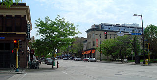
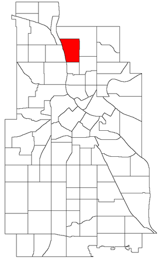
Northeast is a defined community in the U.S. city of Minneapolis that is composed of 13 smaller neighborhoods whose street addresses end in "NE". Unofficially it also includes the neighborhoods of the University community which have "NE" addresses, and the entirety of the Old Saint Anthony business district, which sits on the dividing line of "NE" and "SE" addresses. In the wider community, this business district, which is the oldest settlement in the city, is often identified as the heart of Northeast, in part because it lies across the Mississippi River from Downtown Minneapolis. Northeast is sometimes referred to as "Nordeast", reflecting the history of northern and eastern European immigrants and their language influence.

<span class="mw-page-title-main">Bottineau, Minneapolis</span> Neighborhood in Hennepin, Minnesota, United States

Bottineau is a neighborhood in the Northeast community of Minneapolis.

<span class="mw-page-title-main">Columbia Park, Minneapolis</span> Neighborhood in Hennepin, Minnesota, United States

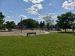
Columbia Park is a neighborhood in the Northeast community in Minneapolis. Its boundaries are 37th Avenue NE to the north, Central Avenue to the east, 27th Avenue NE to the south, and both University Avenue & Saint Anthony Parkway streets to the west.

<span class="mw-page-title-main">St. Anthony West, Minneapolis</span> Neighborhood in Hennepin, Minnesota, United States

Saint Anthony West is a neighborhood in the Northeast community of Minneapolis.

<span class="mw-page-title-main">History of Minneapolis</span> History of a US City

Minneapolis is the largest city by population in the U.S. state of Minnesota, and the county seat of Hennepin County. The origin and growth of the city was spurred by the proximity of Fort Snelling, the first major United States military presence in the area, and by its location on Saint Anthony Falls, which provided power for sawmills and flour mills.

Minneapolis is the largest city in the state of Minnesota in the United States, and the county seat of Hennepin County.

<span class="mw-page-title-main">Charles M. Loring</span> American businessperson, miller and publicist

Charles Morgridge Loring was an American businessman, miller and publicist. Raised in Maine to be a sea captain, Loring instead became a civic leader in Minneapolis, Minnesota where he was a wealthy flour miller and in Riverside, California where he helped to build the first city hall. He was a popular and generous man who enjoyed many friendships and business associations.

<span class="mw-page-title-main">King Field, Minneapolis</span> Neighborhood in Hennepin, Minnesota, United States

King Field is a neighborhood in the Southwest community in Minneapolis, Minnesota. Its boundaries are 36th Street to the north, Interstate 35W to the east, 46th Street to the south, and Lyndale Avenue to the west. King Field, within the King Field neighborhood is a park named after Martin Luther King Jr.

<span class="mw-page-title-main">Marshall Terrace, Minneapolis</span> Neighborhood in Hennepin, Minnesota, United States

Marshall Terrace is a neighborhood in the Northeast community in Minneapolis.

<span class="mw-page-title-main">Sheridan, Minneapolis</span> Neighborhood in Hennepin, Minnesota, United States

Sheridan is a neighborhood in the Northeast community of Minneapolis.

<span class="mw-page-title-main">Neighborhoods in Saint Paul, Minnesota</span>

Saint Paul, Minnesota, consists of 17 officially defined city districts or neighborhoods.

<span class="mw-page-title-main">Trails in Minneapolis</span>

Minneapolis is often considered one of the top biking and walking cities in the United States due to its vast network of trails and dedicated pedestrian areas. In 2020, Walk Score rated Minneapolis as 13th highest among cities over 200,000 people. Some bicycling ratings list Minneapolis at the top of all United States cities, while others list Minneapolis in the top ten. There are over 80 miles (130 km) of paved, protected pathways in Minneapolis for use as transportation and recreation. The city's Grand Rounds National Scenic Byway parkway system accounts for the vast majority of the city's shared-use paths at approximately 50 miles (80 km) of dedicated biking and walking areas. By 2008, other city, county, and park board areas accounted for approximately 30 miles (48 km) of additional trails, for a city-wide total of approximately 80 miles (130 km) of protected pathways. The network of shared biking and walking paths continued to grow into the late 2010s with the additions of the Hiawatha LRT Trail gap remediation, Min Hi Line pilot projects, and Samatar Crossing. The city also features several natural-surface hiking trails, mountain-biking paths, groomed cross-country ski trails in winter, and other pedestrian walkways.

<span class="mw-page-title-main">Mississippi Gorge Regional Park</span> Urban park in Minnesota, United States

Mississippi Gorge Regional Park is a regional park along the east and west bluffs of the Mississippi River in the cities of Minneapolis and Saint Paul in the U.S. state of Minnesota. The two-city park area is between Mississippi river miles 848 and 852, from just south of Northern Pacific Bridge Number 9 to just north of Minnehaha Regional Park, and lies within the Mississippi National River and Recreation Area. The park area protects scenic and natural areas of the Mississippi River gorge, the only true gorge along the entire length of the 2,320-mile (3,730 km) river.

References

  1. "Waite Park neighborhood in Minneapolis, Minnesota (MN), 55418 detailed profile". City-Data. 2011. Retrieved 2013-11-16.
  2. "Waite Park neighborhood data". Minnesota Compass. Retrieved 2023-04-02.
  3. Waite Park, Minneapolis, MN. Google Earth. Retrieved 2011-03-09.