Loring Park, Minneapolis

Last updated
Loring Park
MinneapolisLoringParkNeighborhood.PNG
Location of the Loring Park neighborhood within the U.S. city of Minneapolis
Coordinates: 44°58′12″N93°17′02″W / 44.97000°N 93.28389°W / 44.97000; -93.28389
CountryUnited States
State Minnesota
County Hennepin
City Minneapolis
Community Central
City Council Ward7
Government
  Council Member Katie Cashman
Area
[1]
  Total0.452 sq mi (1.17 km2)
  Land0.452 sq mi (1.17 km2)
Population
 (2020) [2]
  Total9,718
  Density22,000/sq mi (8,300/km2)
Time zone UTC-6 (CST)
  Summer (DST) UTC-5 (CDT)
ZIP code
55403, 55404
Area code 612
Historical population
CensusPop.Note
1980 5,908
1990 6,58611.5%
2000 7,50113.9%
2010 7,8735.0%
2020 9,71823.4%

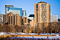
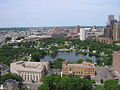
Loring Park is a neighborhood in the Central Community of Minneapolis, Minnesota. Located on the southwest corner of downtown Minneapolis, it also lends its name to Loring Park, the largest park in the neighborhood. The official boundaries of the neighborhood are Lyndale Avenue to the west, Interstate 394 to the north, 12th Street to the northeast, Highway 65 to the east, and Interstate 94 to the south. It is located in Minneapolis City Council Ward 7, [3] represented by Katie Cashman.

Contents

Neighborhood characteristics

Loring Park is locally known for its diverse social environment and as a nexus for many arts and cultural events, boasting over 300 businesses and institutions. Loring Park hosts the annual Twin Cities Pride Festival and is the end location of the pride parade. The Loring Park District, according to its official site, offers the "quintessential urban lifestyle," a blend of "condominium and apartment living." The philosophy of the district is one of coalescence: it seeks to mix the old with the new, desiring to become quaint and charming through its combining of the modern with the "historic brownstone." [4]

The Loring Greenway connects Nicollet Mall with Loring Park. The park is surrounded by apartment buildings, many dating from the early 1900s, although recent construction in the area has brought many new town homes and condominiums to the area. In 1972, the Loring Park Development District was created to use tax increment financing to demolish older apartment buildings in an approximately 10-block area and build new higher density buildings and commercial development, such as the Hyatt hotel on Nicollet. The Loring Greenway was created as part of this district. [5] The neighborhood includes part of the Harmon Place Historic District. [6]

Notable buildings

Demographics

In the 2020 Census, 9,718 people lived in the Loring Park neighborhood. [7] According to the 5-year American Community Survey (ACS) data for 2017-2021, 72% of residents were white, 10.9% were Black, 4.7% Asian, 4.6% two or more races, and 5.3% Hispanic or Latino. [8] The neighborhood is majority renters. In the 2017-2021 ACS data, 68.6% of housing units were occupied by renters and 19.6% by owners. The average household size was 1.3 for both owners and renters. [9]


Racial composition2020 [10]
White (non-Hispanic)72.6%
Black or African American (non-Hispanic)9.9%
Hispanic or Latino 5.0%
Asian (non-Hispanic)5.3%
Other race (non-Hispanic)n/a
Two or more races (non-Hispanic)3.7%

Related Research Articles

<span class="mw-page-title-main">Seward, Minneapolis</span> Neighborhood of Minneapolis

The Seward neighborhood in Minneapolis, Minnesota, United States, is a neighborhood in the Longfellow community of Minneapolis located geographically southeast of downtown. It consists of the land bordered by the Hiawatha Avenue industrial district to the west, Minneapolis Midtown Greenway to the south, the Mississippi River to the east, and Interstate 94 to the north.

<span class="mw-page-title-main">Whittier, Minneapolis</span> Neighborhood in Hennepin, Minnesota, United States

Whittier is a neighborhood within the Powderhorn community in the U.S. city of Minneapolis, Minnesota, bounded by Franklin Avenue on the north, Interstate 35W on the east, Lake Street on the south, and Lyndale Avenue on the west. It is known for its many diverse restaurants, coffee shops and Asian markets, especially along Nicollet Avenue. The neighborhood is home to the Minneapolis Institute of Art, the Minneapolis College of Art and Design, and the Children's Theatre Company.

<span class="mw-page-title-main">Neighborhoods of Minneapolis</span> Official communities and neighborhood of Minneapolis

Minneapolis is officially defined by its city council as divided into 83 neighborhoods. The neighborhoods are historically grouped into 11 communities. Informally, there are city areas with colloquial labels. Residents may also group themselves by their city street suffixes, North, Northeast, South, Southeast, and Southwest.

<span class="mw-page-title-main">Lowry Hill East, Minneapolis</span> Neighborhood in Hennepin, Minnesota, United States

Lowry Hill East, also known as the Wedge because of its wedge-like shape, is a neighborhood in southwest Minneapolis, Minnesota, United States, part of the Calhoun Isles community. Lowry Hill East developed in the 1880s along a horse-drawn streetcar line built by Thomas Lowry. The interior of the neighborhood is residential, with large early 20th century homes and multi-unit apartment buildings, while the border streets are lined with bars, restaurants, grocery stores, coffeeshops, and other small businesses. Most housing is renter-occupied.

<span class="mw-page-title-main">Windom, Minneapolis</span> Neighborhood in Hennepin, Minnesota, United States

The Windom neighborhood is located in the Southwest community of Minneapolis. Its borders are Diamond Lake Road and West 54th Street to the north, Interstate 35W to the east, West 62nd Street to the south, and Lyndale Avenue South and Highway 121 to the west. Windom is a part of Ward 11, currently represented by Minneapolis City Council member Emily Koski.

<span class="mw-page-title-main">Lake Street (Minneapolis)</span>

Lake Street is a major east-west thoroughfare between 29th and 31st streets in Minneapolis, Minnesota United States. From its western most end at the city's limits, Lake Street reaches the Chain of Lakes, passing over a small channel linking Bde Maka Ska and Lake of the Isles, and at its eastern most end it reaches the Mississippi River. In May 2020, the Lake Street corridor suffered extensive damage during local unrest following the murder of George Floyd. In August of the same year, city officials designated East Lake Street as one of seven cultural districts to promote racial equity, preserve cultural identity, and promote economic growth.

<span class="mw-page-title-main">Elliot Park, Minneapolis</span> Neighborhood in Hennepin, Minnesota, United States

Elliot Park is a neighborhood within the larger Central community in Minneapolis. It is part of Ward 6 of the Minneapolis City Council, represented by Jamal Osman.

<span class="mw-page-title-main">Central, Minneapolis</span> Community of Minneapolis

Central is a defined community in Minneapolis that consists of six smaller official neighborhoods around the downtown and central business core. It also includes the many old flour mills, the Mill District, and other historical and industrial areas of downtown Minneapolis. It also includes some high-density residential areas surrounding it, excluding areas east of the Mississippi River. Businesses and government buildings are based in the Central area include the corporate headquarters of the Star Tribune, Target, US Bancorp, the Hennepin County Government Center, Minneapolis Central Library, Minneapolis City Hall, and the broadcast facilities of the Minnesota CBS station WCCO-TV.

<span class="mw-page-title-main">Longfellow, Minneapolis</span> Community of Minneapolis

Longfellow, also referred to as Greater Longfellow is a defined community in Minneapolis, Minnesota which includes five smaller neighborhoods inside of it: Seward, Cooper, Hiawatha, Howe and Longfellow. The community is a mix of agri-industrial properties along the old Northern Pacific Railway, expansive parkland surrounding the famous Minnehaha Falls, and smaller residential areas.

<span class="mw-page-title-main">Stevens Square, Minneapolis</span> Neighborhoods of Minneapolis in Hennepin, Minnesota, United States

Stevens Square is the southernmost neighborhood of the Central community in Minneapolis. It is bordered on Lyndale Avenue on the west, Franklin Avenue on the south, and Interstates 94 and 35W on the north and east, respectively. The portion west of Nicollet Avenue can be referred to as Loring Heights; the portion to the East as Stevens Square.

<span class="mw-page-title-main">University, Minneapolis</span> Community of Minneapolis

University is a community in Minneapolis. It is composed of seven smaller neighborhoods. It also contains the University of Minnesota campus. Most of the community is commonly referred to as Southeast Minneapolis due street names with a SE suffix.

<span class="mw-page-title-main">Nicollet Island/East Bank, Minneapolis</span> Neighborhood in Hennepin, Minnesota, United States

Nicollet Island/East Bank is a neighborhood in the University community of Minneapolis. It is a part of Minneapolis City Council Ward 3, represented by Michael Rainville.

<span class="mw-page-title-main">Downtown West, Minneapolis</span> Neighborhood in Hennepin, Minnesota, United States

Downtown West is an official neighborhood in Minneapolis, part of the larger Central community. It is the heart of downtown Minneapolis, containing the bulk of high-rise office buildings in the city, and is what comes to mind when most Minneapolitans think of "downtown". The neighborhood is split between Wards 3 and 7 of the Minneapolis City Council, represented by Michael Rainville and Katie Cashman, respectively.

<span class="mw-page-title-main">Downtown East, Minneapolis</span> Neighborhood in Hennepin, Minnesota, United States

Downtown East is an official neighborhood in Minneapolis, Minnesota, United States. It is in Ward 3, currently represented by council member Michael Rainville.

<span class="mw-page-title-main">Como, Minneapolis</span> Neighborhood in Hennepin, Minnesota, United States

Como is a neighborhood within the University community of Minneapolis. It is sometimes referred to as Southeast Como, due to many of its streets ending in SE, and possibly to differentiate it from the Como neighborhood in neighboring Saint Paul. Its boundaries are East Hennepin Avenue to the north, 33rd Avenue Southeast to the east, the Southeast Industrial Area to the south, and Interstate 35W to the west.

<span class="mw-page-title-main">Tangletown, Minneapolis</span> Neighborhood in Hennepin, Minnesota, United States

Tangletown is a neighborhood in the Southwest community of Minneapolis. The neighborhood was officially known as Fuller until 1996 when it was changed to the present name, which reflects the winding streets in the neighborhood that do not conform to the regular street grid of South Minneapolis. The neighborhood boundaries are 46th Street to the north, Interstate 35W to the east, Diamond Lake Road to the south, and Lyndale Avenue South to the west. Tangletown is a part of Ward 11, currently represented by Minneapolis City Council member Emily Koski.

<span class="mw-page-title-main">Sumner-Glenwood, Minneapolis</span> Neighborhood in Hennepin, Minnesota, United States

Sumner-Glenwood is a neighborhood in the Near North community of Minneapolis. The neighborhood is roughly contained by 15 city blocks bordered to the north by 11th Avenue North, to the south by Glenwood Avenue, to the east by Interstate 94, and to the west by both Girard Terrace and Emerson Avenue North. It is located in Ward 5, represented by city council member Jeremiah Ellison. The neighborhood includes the Heritage Park mixed-use area.

<span class="mw-page-title-main">King Field, Minneapolis</span> Neighborhood in Hennepin, Minnesota, United States

King Field is a neighborhood in the Southwest community in Minneapolis, Minnesota. Its boundaries are 36th Street to the north, Interstate 35W to the east, 46th Street to the south, and Lyndale Avenue to the west. King Field, within the King Field neighborhood is a park named after Martin Luther King Jr.

<span class="mw-page-title-main">Loring Park</span> Urban park in Minneapolis, Minnesota

Loring Park is a park in the Loring Park neighborhood of Minneapolis, Minnesota.

<span class="mw-page-title-main">Loring Greenway</span> Pedestrian greenway in Minneapolis

Loring Greenway is a 1,500-foot linear pedestrian greenway in downtown Minneapolis that connects Nicollet Mall with Loring Park. It was designed by landscape architect M. Paul Friedberg, who also designed Peavey Plaza near the Nicollet Mall end of the greenway. Opened in 1979, it was part of the Loring Park Development District that razed older properties, created the adjacent Hyatt hotel and built new surrounding multi-family apartment and townhouse buildings in the Loring Park neighborhood. Now approximately 2,500 housing units flank the greenway spine. Originally retail businesses were planned to line the greenway, but private development focused on residential, and the small commercial spaces never materialized. The greenway is noted on a historic marker in a series along the north side of West Grant Street between LaSalle and Nicollet.

References

  1. "Loring Park neighborhood in Minneapolis, Minnesota (MN), 55403, 55404 detailed profile". City-Data. 2011. Retrieved 2013-11-12.
  2. "Loring Park neighborhood data". Minnesota Compass. Retrieved 2023-02-19.
  3. "Find My Ward". City of Minneapolis. Retrieved 22 April 2024.
  4. "Home | Loring Park District - Downtown Minneapolis". Loring Park District. Retrieved 2016-03-08.
  5. "Loring Park: Loring Greenway and Housing Historical Marker". www.hmdb.org. Retrieved 2023-11-20.
  6. Minneapolis, City of. "Harmon Place Historic District". www2.minneapolismn.gov. Retrieved 2023-11-20.
  7. "Loring Park | MN Compass". Minnesota Compass. Retrieved 2023-11-20.
  8. "Loring Park | MN Compass". Minnesota Compass. Retrieved 2023-11-20.
  9. "Loring Park | MN Compass". Minnesota Compass. Retrieved 2023-11-20.
  10. "Loring Park | MN Compass".