Polhovica

Last updated
Polhovica
Slovenia location map.svg
Red pog.svg
Polhovica
Location in Slovenia
Coordinates: 45°50′28.65″N15°16′41.04″E / 45.8412917°N 15.2780667°E / 45.8412917; 15.2780667 Coordinates: 45°50′28.65″N15°16′41.04″E / 45.8412917°N 15.2780667°E / 45.8412917; 15.2780667
Country Flag of Slovenia.svg Slovenia
Traditional region Lower Carniola
Statistical region Southeast Slovenia
Municipality Šentjernej
Area
  Total 2.18 km2 (0.84 sq mi)
Elevation 190.4 m (624.7 ft)
Population (2002)
  Total 42
[1]

Polhovica (pronounced  [ˈpou̯ːxɔʋitsa] ) is a village in the Municipality of Šentjernej in southeastern Slovenia. Its territory extends to the woods west of the main settlement up to the banks of the Krka River. The entire municipality was traditionally part of Lower Carniola. It is now included in the Southeast Slovenia Statistical Region. [2]

Village Small clustered human settlement smaller than a town

A village is a clustered human settlement or community, larger than a hamlet but smaller than a town, with a population ranging from a few hundred to a few thousand. Though villages are often located in rural areas, the term urban village is also applied to certain urban neighborhoods. Villages are normally permanent, with fixed dwellings; however, transient villages can occur. Further, the dwellings of a village are fairly close to one another, not scattered broadly over the landscape, as a dispersed settlement.

Šentjernej Town and Municipality in Slovenia

Šentjernej is a small town and a municipality in southeastern Slovenia. The area was traditionally part of Lower Carniola. It is now included in the Southeast Slovenia Statistical Region.

Slovenia republic in Central Europe

Slovenia, officially the Republic of Slovenia, is a sovereign state located in southern Central Europe at a crossroads of important European cultural and trade routes. It is bordered by Italy to the west, Austria to the north, Hungary to the northeast, Croatia to the southeast, and the Adriatic Sea to the southwest. It covers 20,273 square kilometers (7,827 sq mi) and has a population of 2.07 million. One of the successor states of the former Yugoslavia, Slovenia is a parliamentary republic and a member of the United Nations, of the European Union, and of NATO. The capital and largest city is Ljubljana.

Contents

Church

St. Sigismund's Church in Polhovica SvZiga-Polhovica-Slovenia.jpg
St. Sigismund's Church in Polhovica

The local church, built on a slight elevation in the centre of the village, is dedicated to Saint Sigismund (Slovene : sveti Žiga) and belongs to the parish of Šentjernej. In written documents dating to the 17th century it is mentioned as a Romanesque building that had been recently renovated. The main and the only altar dates to the 19th century. [3] The church was thoroughly renovated from 1998 until 2002. [4]

Church (building) building constructed for Christian worship

A church building or church house, often simply called a church, is a building used for Christian religious activities, particularly for Christian worship services. The term is often used by Christians to refer to the physical buildings where they worship, but it is sometimes used to refer to buildings of other religions. In traditional Christian architecture, the church is often arranged in the shape of a Christian cross. When viewed from plan view the longest part of a cross is represented by the aisle and the junction of the cross is located at the altar area.

Sigismund of Burgundy King of burgundy

Sigismund was King of the Burgundians from 516 to his death. He was the son of king Gundobad and Caretene. He succeeded his father in 516. Sigismund and his brother Godomar were defeated in battle by Clovis' sons and Godomar fled. Sigismund was taken by Chlodomer, King of Orléans, where he was kept as a prisoner. Later he, his wife and children were executed. Godomar then rallied the Burgundian army and won back his kingdom.

Slovene language language spoken in Slovenia

Slovene or Slovenian belongs to the group of South Slavic languages. It is spoken by approximately 2.5 million speakers worldwide, the majority of whom live in Slovenia. It is the first language of about 2.1 million Slovenian people and is one of the 24 official and working languages of the European Union.

Related Research Articles

Cerov Log Place in Lower Carniola, Slovenia

Cerov Log is a small settlement in the Gorjanci Hills in the Municipality of Šentjernej in southeastern Slovenia. Its territory extends right to the border with Croatia. The area was traditionally part of Lower Carniola. It is now included in the Southeast Slovenia Statistical Region.

Čadraže Place in Lower Carniola, Slovenia

Čadraže is a village on the right bank of the Krka River in the Municipality of Šentjernej in southeastern Slovenia. The area was traditionally part of Lower Carniola. It is now included in the Southeast Slovenia Statistical Region.

Dolenja Stara Vas Place in Lower Carniola, Slovenia

Dolenja Stara Vas is a settlement immediately southeast of the town of Šentjernej in southeastern Slovenia. The area was traditionally part of Lower Carniola. It is now included in the Southeast Slovenia Statistical Region. The village belongs to the Village Community of Grmovlje.

Dolenje Mokro Polje Place in Lower Carniola, Slovenia

Dolenje Mokro Polje is a settlement in the Municipality of Šentjernej in southeastern Slovenia. The area was traditionally part of Lower Carniola. It is now included in the Southeast Slovenia Statistical Region. The village was first mentioned in 1227 as Unter Nassenfeld. Due to flooding, the villagers began to settle at a nearby location, where it still stands. Only a few ruins have survived at the old location. According to the 2003 census, there are 36 houses in the village. Villagers attend Saint Sigismund's Church in the neighboring village of Polhovica.

Drama, Šentjernej Place in Lower Carniola, Slovenia

Drama is a village in the Municipality of Šentjernej in southeastern Slovenia. The area was traditionally part of Lower Carniola. It is now included in the Southeast Slovenia Statistical Region. It includes the hamlets of Dolenja Gomila, formerly an independent settlement, to the west and Otok to the northwest.

Drča in Lower Carniola, Slovenia

Drča is a village in the foothills of the Gorjanci Hills in the Municipality of Šentjernej in southeastern Slovenia. The area was traditionally part of Lower Carniola. It is now included in the Southeast Slovenia Statistical Region.

Gorenja Stara Vas Place in Lower Carniola, Slovenia

Gorenja Stara Vas is a village in the Municipality of Šentjernej in southeastern Slovenia. The area was traditionally part of Lower Carniola. It is now included in the Southeast Slovenia Statistical Region.

Gorenje Mokro Polje Place in Lower Carniola, Slovenia

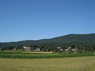
Gorenje Mokro Polje is a settlement west of Šentjernej in southeastern Slovenia. The area was traditionally part of Lower Carniola. It is now included in the Southeast Slovenia Statistical Region.

Gorenje Vrhpolje Place in Lower Carniola, Slovenia

Gorenje Vrhpolje is a settlement southwest of Šentjernej in southeastern Slovenia. The area was traditionally part of Lower Carniola. It is now included in the Southeast Slovenia Statistical Region.

Groblje pri Prekopi in Lower Carniola, Slovenia

Groblje pri Prekopi is a settlement northeast of Šentjernej in southeastern Slovenia. The area was traditionally part of Lower Carniola. It is now included in the Southeast Slovenia Statistical Region.

Hrastje, Šentjernej Place in Lower Carniola, Slovenia

Hrastje is a small settlement in the foothills of the Gorjanci Hills in the Municipality of Šentjernej in southeastern Slovenia. The area was traditionally part of Lower Carniola. It is now included in the Southeast Slovenia Statistical Region.

Ledeča Vas Place in Lower Carniola, Slovenia

Ledeča Vas is a village east of Šentjernej, at the foot of the Gorjanci Hills in southeastern Slovenia. The area was traditionally part of Lower Carniola. It is now included in the Southeast Slovenia Statistical Region.

Mihovica Place in Lower Carniola, Slovenia

Mihovica is a settlement on the right bank of the Krka River in the Municipality of Šentjernej in southeastern Slovenia. Traditional 19th-century farmhouses and outbuildings are preserved in the village core and it has been included on the Slovenian Ministry of Culture's register of national heritage. The area was traditionally part of Lower Carniola. It is now included in the Southeast Slovenia Statistical Region.

Ostrog, Šentjernej Place in Lower Carniola, Slovenia

Ostrog is a small village north of Dolnja Prekopa in the Municipality of Šentjernej in southeastern Slovenia. Its territory extends north of the main settlement to the banks of the Krka River. The entire municipality was traditionally part of Lower Carniola. It is now included in the Southeast Slovenia Statistical Region.

Rakovnik, Šentjernej Place in Lower Carniola, Slovenia

Rakovnik is a small settlement in the Municipality of Šentjernej in southeastern Slovenia. It lies in the foothills of the Gorjanci range. The entire municipality was traditionally part of Lower Carniola. It is now included in the Southeast Slovenia Statistical Region.

Šmarje, Šentjernej Place in Lower Carniola, Slovenia

Šmarje is a settlement in the Municipality of Šentjernej in southeastern Slovenia. It was traditionally part of Lower Carniola and is now included in the Southeast Slovenia Statistical Region.

Tolsti Vrh, Šentjernej Place in Lower Carniola, Slovenia

Tolsti Vrh is a settlement in the foothills of the Žumberak/Gorjanci range in the Municipality of Šentjernej in southeastern Slovenia. It was traditionally part of Lower Carniola and is now included in the Southeast Slovenia Statistical Region.

Hrast pri Vinici Place in White Carniola, Slovenia

Hrast pri Vinici is a village north of Vinica in the Municipality of Črnomelj in the White Carniola area of southeastern Slovenia. The area is part of the traditional region of Lower Carniola and is now included in the Southeast Slovenia Statistical Region.

Nova Lipa, Črnomelj Place in White Carniola, Slovenia

Nova Lipa is a village northwest of Vinica in the Municipality of Črnomelj in the White Carniola area of southeastern Slovenia. The area is part of the traditional region of Lower Carniola and is now included in the Southeast Slovenia Statistical Region.

References