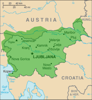
Apnenik is a settlement in the foothills of the Gorjanci range in the Municipality of Šentjernej in southeastern Slovenia. The area was traditionally part of Lower Carniola. It is now included in the Southeast Slovenia Statistical Region.

Breška Vas is a small settlement on the right bank of the Krka River in the Municipality of Šentjernej in southeastern Slovenia. The area was traditionally part of Lower Carniola. It is now included in the Southeast Slovenia Statistical Region.

Dobravica is a settlement immediately west of the town of Šentjernej in southeastern Slovenia. The area was traditionally part of Lower Carniola. It is now included in the Southeast Slovenia Statistical Region.

Dolenja Brezovica is a settlement immediately to the south of Šentjernej in southeastern Slovenia. The area was traditionally part of Lower Carniola. It is now included in the Southeast Slovenia Statistical Region.

Dolenja Stara Vas is a settlement immediately southeast of the town of Šentjernej in southeastern Slovenia. The area was traditionally part of Lower Carniola. It is now included in the Southeast Slovenia Statistical Region. The village belongs to the Village Community of Grmovlje.

Gorenja Stara Vas is a village in the Municipality of Šentjernej in southeastern Slovenia. The area was traditionally part of Lower Carniola. It is now included in the Southeast Slovenia Statistical Region.

Gruča is a small settlement east of Šentjernej in southeastern Slovenia. The area was traditionally part of Lower Carniola. It is now included in the Southeast Slovenia Statistical Region.

Hrastje is a small settlement in the foothills of the Gorjanci Hills in the Municipality of Šentjernej in southeastern Slovenia. The area was traditionally part of Lower Carniola. It is now included in the Southeast Slovenia Statistical Region.

Ledeča Vas is a village east of Šentjernej, at the foot of the Gorjanci Hills in southeastern Slovenia. The area was traditionally part of Lower Carniola. It is now included in the Southeast Slovenia Statistical Region.

Mršeča Vas is a settlement on the left bank of the Krka River in the Municipality of Šentjernej in southeastern Slovenia. The area was traditionally part of Lower Carniola. It is now included in the Southeast Slovenia Statistical Region.

Orehovica is a village southwest of Šentjernej in southeastern Slovenia. The area was traditionally part of Lower Carniola. It is now included in the Southeast Slovenia Statistical Region.

Pristavica is a small settlement in the Municipality of Šentjernej in southeastern Slovenia. It lies on a slight elevation above the right bank of the Krka River southwest of Gorenja Gomila. The entire municipality was traditionally part of Lower Carniola. It is now included in the Southeast Slovenia Statistical Region.

Sela pri Šentjerneju is a settlement south of Šentjernej in southeastern Slovenia. The Municipality of Šentjernej was traditionally part of Lower Carniola. It is now included in the Southeast Slovenia Statistical Region.

Šmalčja Vas is a settlement immediately north of the town of Šentjernej in southeastern Slovenia. The Municipality of Šentjernej was traditionally part of Lower Carniola. It is now included in the Southeast Slovenia Statistical Region.

Vrbovce is a settlement in the foothills of the Žumberak/Gorjanci range in the Municipality of Šentjernej in southeastern Slovenia. It was traditionally part of Lower Carniola and is now included in the Southeast Slovenia Statistical Region.

Vrh pri Šentjerneju is a small settlement west of Šentjernej in southeastern Slovenia. The entire Municipality of Šentjernej was traditionally part of Lower Carniola and is now included in the Southeast Slovenia Statistical Region.

Zameško is a small settlement on the right bank of the Krka River in the Municipality of Šentjernej in southeastern Slovenia. The entire municipality was traditionally part of Lower Carniola and is now included in the Southeast Slovenia Statistical Region.

Dobrava pri Škocjanu is a settlement in the Municipality of Škocjan in southeastern Slovenia. It lies on the left bank of the Krka River on the regional road leading south from Škocjan to Šentjernej. Within the municipality, it belongs to the Village Community of Dobrava pri Škocjanu and Tomažja Vas. The area is part of the historical region of Lower Carniola. The municipality is now included in the Southeast Slovenia Statistical Region.

Dobruška Vas is a village in the Municipality of Škocjan in southeastern Slovenia. Within the municipality, it belongs to the Village Community of Grmovlje. It lies on the regional road leading south from Škocjan to Šentjernej. The A2 motorway runs just east of the settlement. The area is part of the historical region of Lower Carniola. The municipality is now included in the Southeast Slovenia Statistical Region. The settlement includes the hamlets of Cesta and Zatreb.


