Pond Creek | |
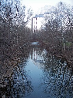
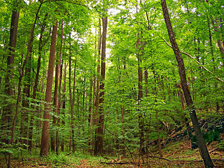
Pond Creek northwest of Flinn in 2010 | |
Country | United States |
---|---|
State | West Virginia |
Counties | Wood, Jackson |
Source | |
- location | south of Rockport |
- elevation | 978 ft (298 m) [1] |
- coordinates | 39°03′02″N81°33′22″W / 39.0506351°N 81.5562353°W [2] |
Mouth | Ohio River |
- location | Pond Creek |
- elevation | 561 ft (171 m) [2] |
- coordinates | 39°05′38″N81°44′38″W / 39.0939671°N 81.7440201°W Coordinates: 39°05′38″N81°44′38″W / 39.0939671°N 81.7440201°W [2] |
Length | 16 mi (26 km) |
Basin | 43 sq mi (111 km2) |
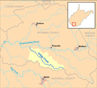
Pond Creek and its watershed in Wood and Jackson counties, West Virginia |
Pond Creek is a tributary of the Ohio River, 16 miles (26 km) long, [3] in western West Virginia in the United States. Via the Ohio River, it is part of the watershed of the Mississippi River, draining an area of 43 square miles (110 km2) [4] on the unglaciated portion of the Allegheny Plateau.
A tributary or affluent is a stream or river that flows into a larger stream or main stem river or a lake. A tributary does not flow directly into a sea or ocean. Tributaries and the main stem river drain the surrounding drainage basin of its surface water and groundwater, leading the water out into an ocean.
The Ohio River is a 981-mile (1,579 km) long river in the midwestern United States that flows southwesterly from western Pennsylvania south of Lake Erie to its mouth on the Mississippi River at the southern tip of Illinois. It is the second largest river by discharge volume in the United States and the largest tributary by volume of the north-south flowing Mississippi River that divides the eastern from western United States. The river flows through or along the border of six states, and its drainage basin includes parts of 15 states. Through its largest tributary, the Tennessee River, the basin includes several states of the southeastern U.S. It is the source of drinking water for three million people.
West Virginia is a state located in the Appalachian region in the Southern United States that is also considered to be a part of the Middle Atlantic States. It is bordered by Pennsylvania to the north, Maryland to the east and northeast, Virginia to the southeast, Kentucky to the southwest, and Ohio to the northwest. West Virginia is the 41st largest state by area, and is ranked 38th in population. The capital and largest city is Charleston.
Pond Creek flows for most of its length in southern Wood County; its watershed also drains a portion of northern Jackson County. It rises south of Rockport and flows generally west-northwestward through the unincorporated communities of Lowdell, Jerrys Run, and Flinn. East of Flinn and again near its mouth, the creek briefly enters Jackson County. It flows into the Ohio River on the boundary of Jackson and Wood counties, at the community of Pond Creek. [5]
Wood County is a county in the U.S. state of West Virginia. As of the 2010 census, the population was 86,956, making it West Virginia's fifth-most populous county. Its county seat is Parkersburg. The county was formed in 1798 from the western part of Harrison County and named for James Wood, governor of Virginia from 1796 to 1799.
Jackson County is a county in the U.S. state of West Virginia. As of the 2010 census, the population was 29,211. Its county seat is Ripley, and its largest municipality is Ravenswood. The county was formed in 1831 from parts of Kanawha, Wood, and Mason Counties, and named for Andrew Jackson, seventh President of the United States.
Rockport is an unincorporated community in Wood County, West Virginia, United States. It lies at an elevation of 705 feet (215 m), along Tygart Creek. It is the last exit in Southern Wood County along I-77 and is unincorporated, with the ZIP code of 26169.
Downstream of Flinn it collects Little Pond Creek [6] from the south. Little Pond Creek flows in Jackson County for most of its course, northwestward through the communities of Willowdale and Topins Grove. [5]
Willowdale is an unincorporated community in Jackson County, West Virginia.
Topins Grove is an unincorporated community in Jackson County, West Virginia, United States. Topins Grove is located on Little Pond Creek and County Highway 6 7.7 miles (12.4 km) north-northeast of Ravenswood. Topins Grove once had a post office, which is now closed.
According to the West Virginia Department of Environmental Protection, approximately 82% of the Pond Creek watershed is forested, mostly deciduous. Approximately 18% is used for pasture and agriculture. [4]
A forest is a large area dominated by trees. Hundreds of more precise definitions of forest are used throughout the world, incorporating factors such as tree density, tree height, land use, legal standing and ecological function. According to the widely used Food and Agriculture Organization definition, forests covered 4 billion hectares (9.9×10⁹ acres) (15 million square miles) or approximately 30 percent of the world's land area in 2006.
In the fields of horticulture and botany, the term deciduous (/dɪˈsɪdʒuəs/) means "falling off at maturity" and "tending to fall off", in reference to trees and shrubs that seasonally shed leaves, usually in the autumn; to the shedding of petals, after flowering; and to the shedding of ripe fruit.
Hackers Creek is a tributary of the West Fork River, 25.4 miles (40.9 km) long, in north-central West Virginia in the United States. Via the West Fork, Monongahela and Ohio Rivers, it is part of the watershed of the Mississippi River, draining an area of 58 square miles (150 km2) on the unglaciated portion of the Allegheny Plateau. The stream is believed to have been named for a settler named John Hacker (1743-1824), who lived near the creek for over twenty years beginning around 1770, and was said to have been able to "read but not write; and yet he was a magistrate and a patriarch in the settlement."
Tenmile Creek is a tributary of the West Fork River, 26.4 miles (42.5 km) long, in north-central West Virginia in the United States. Via the West Fork, Monongahela and Ohio Rivers, it is part of the watershed of the Mississippi River, draining an area of 126 square miles (330 km2) on the unglaciated portion of the Allegheny Plateau.
Wheeling Creek is a tributary of the Ohio River, 25 miles (40 km) long, in the Northern Panhandle of West Virginia in the United States, with a watershed extending into southwestern Pennsylvania. Via the Ohio River, it is part of the watershed of the Mississippi River, draining an area of approximately 300 square miles (780 km2) on the unglaciated portion of the Allegheny Plateau. It flows into the Ohio River in downtown Wheeling, just downstream of Ohio's Wheeling Creek on the opposite bank. A variant name is Big Wheeling Creek.
Mill Creek is a tributary of the Ohio River, 29.4 miles (47.3 km) long, in western West Virginia in the United States. Via the Ohio, it is part of the watershed of the Mississippi River, draining an area of 234 square miles (610 km2) on the unglaciated portion of the Allegheny Plateau. According to the Geographic Names Information System, it has also been known historically as Big Mill Creek.
Sandy Creek is a tributary of the Ohio River in western West Virginia in the United States. Via the Ohio River, it is part of the watershed of the Mississippi River, draining an area of 124 square miles (320 km2) on the unglaciated portion of the Allegheny Plateau. The creek is 22 miles (35 km) long, or 38.3 miles (61.6 km) including its Left Fork.
The West Fork Little Kanawha River is a tributary of the Little Kanawha River, 48.1 miles (77.4 km) long, in west-central West Virginia in the United States. Via the Little Kanawha and Ohio rivers, it is part of the watershed of the Mississippi River, draining an area of 246 square miles (640 km2) in a rural region on the unglaciated portion of the Allegheny Plateau. By drainage area, it is the second-largest tributary of the Little Kanawha River, after the Hughes River.
Cedar Creek is a tributary of the Little Kanawha River, 31.7 miles (51.0 km) long, in central West Virginia in the United States. Via the Little Kanawha and Ohio rivers, it is part of the watershed of the Mississippi River, draining an area of 81 square miles (210 km2) in a rural region on the unglaciated portion of the Allegheny Plateau.
Spring Creek is a tributary of the Little Kanawha River in western West Virginia in the United States. Via the Little Kanawha and Ohio rivers, it is part of the watershed of the Mississippi River, draining an area of 89 square miles (230 km2) in a rural region on the unglaciated portion of the Allegheny Plateau. It is 25.3 miles (40.7 km) long, or 33.3 miles (53.6 km) long including its Left Fork.
Tygart Creek is a tributary of the Little Kanawha River, 14.5 miles (23.3 km) long, in western West Virginia in the United States. Via the Little Kanawha and Ohio rivers, it is part of the watershed of the Mississippi River, draining an area of 51 square miles (130 km2) on the unglaciated portion of the Allegheny Plateau.
Steer Creek is a tributary of the Little Kanawha River in central West Virginia in the United States. Via the Little Kanawha and Ohio rivers, it is part of the watershed of the Mississippi River, draining an area of 184 square miles (480 km2) in a rural region on the unglaciated portion of the Allegheny Plateau. It is 6.3 miles (10.1 km) long, or 31.7 miles (51.0 km) long including its Right Fork.
Reedy Creek is a tributary of the Little Kanawha River in western West Virginia in the United States. Via the Little Kanawha and Ohio rivers, it is part of the watershed of the Mississippi River, draining an area of 133 square miles (340 km2) in a rural region on the unglaciated portion of the Allegheny Plateau. It is 22.6 miles (36.4 km) long, or 38.5 miles (62.0 km) long including its Left Fork.
Walker Creek is a tributary of the Little Kanawha River, 15.6 miles (25.1 km) long, in western West Virginia in the United States. Via the Little Kanawha and Ohio rivers, it is part of the watershed of the Mississippi River, draining an area of 32 square miles (83 km2) on the unglaciated portion of the Allegheny Plateau.
Worthington Creek is a tributary of the Little Kanawha River, 15.4 miles (24.8 km) long, in western West Virginia in the United States. Via the Little Kanawha and Ohio rivers, it is part of the watershed of the Mississippi River, draining an area of 35 square miles (91 km2) in the city of Parkersburg and its vicinity.
Saltlick Creek is a tributary of the Little Kanawha River, 17.7 miles (28.5 km) long, in central West Virginia in the United States. Via the Little Kanawha and Ohio rivers, it is part of the watershed of the Mississippi River, draining an area of 49 square miles (130 km2) in a rural region on the unglaciated portion of the Allegheny Plateau.
Barkers Creek is a tributary of the Guyandotte River, 8 miles (13 km) long, in southern West Virginia in the United States. Via the Guyandotte and Ohio rivers, it is part of the watershed of the Mississippi River, draining an area of 36.85 square miles (95.4 km2) in a rural area on the unglaciated portion of the Allegheny Plateau.
Island Creek is a tributary of the Guyandotte River, 18.1 miles (29.1 km) long, in southern West Virginia in the United States. Via the Guyandotte and Ohio rivers, it is part of the watershed of the Mississippi River, draining an area of 105 square miles (270 km2) in a rural area on the unglaciated portion of the Allegheny Plateau, in the Logan Coalfield. Island Creek's entire course and drainage area are in Logan County.
Indian Creek is a tributary of the Guyandotte River, 19.7 miles (31.7 km) long, in southern West Virginia in the United States. Via the Guyandotte and Ohio rivers, it is part of the watershed of the Mississippi River, draining an area of 43 square miles (110 km2) in a rural area on the unglaciated portion of the Allegheny Plateau.
Pinnacle Creek is a tributary of the Guyandotte River, 26.6 miles (42.8 km) long, in southern West Virginia in the United States. Via the Guyandotte and Ohio rivers, it is part of the watershed of the Mississippi River, draining an area of 57.23 square miles (148.2 km2) in a rural area on the unglaciated portion of the Allegheny Plateau.
Buckeye Creek is a tributary of Middle Island Creek, 12.7 miles (20.4 km) long, in north-central West Virginia in the United States. Via Middle Island Creek and the Ohio River, it is part of the watershed of the Mississippi River, draining an area of 39.1 square miles (101 km2) in a rural region on the unglaciated portion of the Allegheny Plateau.
Flint Run is a tributary of McElroy Creek, 7.5 miles (12.1 km) long, in northern West Virginia in the United States. Via McElroy Creek, Middle Island Creek, and the Ohio River, it is part of the watershed of the Mississippi River, draining an area of 25.6 square miles (66 km2) in a rural region on the unglaciated portion of the Allegheny Plateau.
|work=
(help)