Poplar Plains, Kentucky

Last updated

Poplar Plains, Kentucky
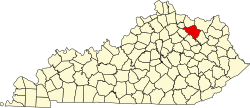
USA Kentucky location map.svg
Red pog.svg
Poplar Plains
Location within the state of Kentucky
Coordinates: 38°21′39″N83°40′28″W / 38.36083°N 83.67444°W / 38.36083; -83.67444
Country United States
State Kentucky
County Fleming
Elevation
[1]
909 ft (277 m)
Time zone UTC-5 (Eastern (EST))
  Summer (DST) UTC-4 (EDT)
ZIP code
41041
Area code 606
GNIS feature ID501127 [1]

Poplar Plains is an unincorporated community in Fleming County, Kentucky, in the United States. [1]

History

A post office was established at Poplar Plains in 1823, and remained in operation until it was discontinued in 1926. [2] Poplar Plains was incorporated in 1831. [3]

Related Research Articles

<span class="mw-page-title-main">Rowan County, Kentucky</span> County in Kentucky, United States

Rowan County is a county located in the northeastern part of the U.S. state of Kentucky, in the Eastern Kentucky Coalfield region. As of the 2020 census, the population was 24,662. Its county seat is Morehead.

<span class="mw-page-title-main">Lewis County, Kentucky</span> County in Kentucky, United States

Lewis County is a county located in the U.S. state of Kentucky. As of the 2020 census, the population was 13,080. Its county seat is Vanceburg.

<span class="mw-page-title-main">Fleming County, Kentucky</span> County in Kentucky, United States

Fleming County is a county located in the U.S. state of Kentucky. As of the 2020 census, the population was 15,082. Its county seat is Flemingsburg. The county was formed in 1798 and named for Colonel John Fleming, an Indian fighter and early settler. It is a moist county. In 1998, the Kentucky General Assembly designated Fleming County as the Covered Bridge Capital of Kentucky.

<span class="mw-page-title-main">Boone County, Illinois</span> County in Illinois, United States

Boone County is a county located in the U.S. state of Illinois. As of the 2020 census, the population was 53,448. Its county seat is Belvidere.

<span class="mw-page-title-main">Flemingsburg, Kentucky</span> City in Kentucky, United States

Flemingsburg is a home rule-class city in Fleming County, Kentucky, in the United States. The population was 2,658 at the 2010 census, down from 3,010 at the 2000 census. It is the seat of Fleming County.

<span class="mw-page-title-main">Poplar Hills, Kentucky</span> City in Kentucky, United States

Poplar Hills is a home rule-class city in Jefferson County, Kentucky, United States. It is a part of the Louisville Metro government, but operates as a city under the Mayor to Commissioner form of government. Per the 2020 census, the population was 380, but the city administration has made several annexation ordinances that have passed and awaits updated information. The current city population is estimated to be 2380. It currently has the highest population density for any city in Kentucky.

<span class="mw-page-title-main">Fleming-Neon, Kentucky</span> City in Kentucky, United States

Fleming-Neon also known as Neon, is a home rule-class city in Letcher County, Kentucky, in the United States. The population was 770 at the 2010 census, down from 840 at the 2000 census.

<span class="mw-page-title-main">Morehead, Kentucky</span> City in Kentucky, United States

Morehead is a home rule-class city located along US 60 and Interstate 64 in Rowan County, Kentucky, in the United States. It is the seat of its county. The population was 7,151 at the time of the 2020 U.S. census.

<span class="mw-page-title-main">Neighborhoods in Louisville, Kentucky</span>

This is a list of official neighborhoods in Louisville, Kentucky. Like many older American cities, Louisville has well-defined neighborhoods, many with well over a century of history as a neighborhood.

<span class="mw-page-title-main">Geography of Louisville, Kentucky</span>

Louisville is a city in Jefferson County, in the U.S. state of Kentucky. It is located at the Falls of the Ohio River.

<span class="mw-page-title-main">Kentucky Route 11</span> Highway in Kentucky

Kentucky Route 11 (KY 11) is an American highway maintained by the Kentucky Transportation Cabinet that runs from Maysville to Barbourville. The route from Maysville to Mount Sterling is being upgraded on a new alignment as part of a "macro-corridor" within the state of Kentucky.

Colonel William Fleming was an American physician, soldier, politician, and planter who served as a local justice of the peace in the mountains of southwestern Virginia and Kentucky, as well as in the Senate of Virginia and briefly acted as the Governor of Virginia during the American Revolutionary War.

<span class="mw-page-title-main">White Plains (Cookeville, Tennessee)</span> Historic house in Tennessee, United States

White Plains is an antebellum plantation house located in Algood, Tennessee near the U.S. city of Cookeville. In the 19th century, the plantation provided a key stopover along the Walton Road, an early stagecoach road connecting Knoxville and Nashville, and in 1854 served as a temporary county seat for the newly formed Putnam County. In 2009, the house was added to the National Register of Historic Places.

<span class="mw-page-title-main">Samuel May House</span> Historic house in Kentucky, United States

The Samuel May House is a Federal style residence located at 690 North Lake Drive in Prestonsburg, Kentucky. It built in 1817 by Samuel May, a Kentucky state representative (1832–1834) and a Kentucky state senator (1835–1838) from Floyd County. It now serves as the Samuel May House Living History Museum. Relatives still living include Jack May, Vince May, Treasa May, Kim May, Eric May, Kevin May, Tonia May, Lisa May.

<span class="mw-page-title-main">Hillsboro Covered Bridge</span> United States historic place

The Hillsboro Covered Bridge, known locally as the "Hillsboro-Grange City Covered Bridge", spans Fox Creek in Fleming County adjacent to Kentucky Route 111, 13.6 miles (21.9 km) southeast of Flemingsburg, Kentucky. Probably built in the late 1860s, it was discontinued in 1968 when it was replaced fifty yards (46 m) upstream by a concrete bridge.

<span class="mw-page-title-main">Ringos Mill Covered Bridge</span> United States historic place

The Ringos Mill Covered Bridge spans Fox Creek in Fleming County, Kentucky, in a single 90-foot span. It was named for a grist mill situated 50 yards downstream.

<span class="mw-page-title-main">1992 United States presidential election in Kentucky</span> Election in Kentucky

The 1992 United States presidential election in Kentucky took place on November 3, 1992, as part of the 1992 United States presidential election. As of the result of the 1990 census, Kentucky lost an electoral vote. Voters chose eight representatives, or electors to the Electoral College, who voted for president and vice president.

Poplar Plains is a census-designated place (CDP) in the town of Westport, Fairfield County, Connecticut, United States. It occupies the northwest corner of the town and is bordered to the southwest by the city of Norwalk, to the northwest by the town of Wilton, to the northeast by the town of Weston, to the east by the Saugatuck River, and to the south by the Merritt Parkway.

Poplar Plains may refer to a location in the United States:

References

  1. 1 2 3 U.S. Geological Survey Geographic Names Information System: Poplar Plains, Kentucky
  2. "Fleming County". Jim Forte Postal History. Retrieved January 4, 2015.
  3. Collins, Lewis (1877). History of Kentucky. p. 230.