
Lake Winnipeg is a very large, relatively shallow 24,514-square-kilometre (9,465 sq mi) lake in North America, in the province of Manitoba, Canada. Its southern end is about 55 kilometres (34 mi) north of the city of Winnipeg. Lake Winnipeg is Canada's sixth-largest freshwater lake and the third-largest freshwater lake contained entirely within Canada, but it is relatively shallow excluding a narrow 36 m (118 ft) deep channel between the northern and southern basins. It is the eleventh-largest freshwater lake on Earth. The lake's east side has pristine boreal forests and rivers that were in 2018 inscribed as Pimachiowin Aki, a UNESCO World Heritage Site. The lake is 416 km (258 mi) from north to south, with remote sandy beaches, large limestone cliffs, and many bat caves in some areas. Manitoba Hydro uses the lake as one of the largest reservoirs in the world. There are many islands, most of them undeveloped.

The Saulteaux, otherwise known as the Plains Ojibwe, are a First Nations band government in Ontario, Manitoba, Saskatchewan, Alberta and British Columbia, Canada. They are a branch of the Ojibwe who pushed west. They formed a mixed culture of woodlands and plains Indigenous customs and traditions.

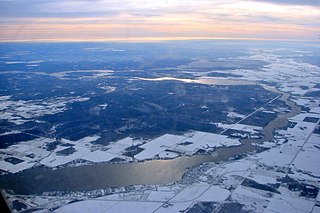
Lake of the Woods is a lake occupying parts of the Canadian provinces of Ontario and Manitoba and the U.S. state of Minnesota. Lake of the Woods is over 70 miles (110 km) long and wide, and contains more than 14,552 islands and 65,000 miles (105,000 km) of shoreline. It is fed by the Rainy River, Shoal Lake, Kakagi Lake and other smaller rivers. The lake drains into the Winnipeg River and then into Lake Winnipeg. Ultimately, its outflow goes north through the Nelson River to Hudson Bay.
The Winnipeg River is a Canadian river that flows roughly northwest from Lake of the Woods in the province of Ontario to Lake Winnipeg in Manitoba. This river is 235 kilometres (146 mi) long from the Norman Dam in Kenora to its mouth at Lake Winnipeg. Its watershed is 106,500 square kilometres (41,100 sq mi) in area, mainly in Canada. About 29,000 square kilometres (11,000 sq mi) of the watershed is in northern Minnesota, United States.

Quetico Provincial Park is a large wilderness park in Northwestern Ontario, Canada, known for its excellent canoeing and fishing. The 4,760 km2 (1,180,000-acre) park shares its southern border with Minnesota's Boundary Waters Canoe Area Wilderness, which is part of the larger Superior National Forest. These large wilderness parks are often collectively referred to as the Boundary Waters or the Quetico-Superior Country.

Nopiming Provincial Park is a natural, provincial park in Manitoba, Canada, located on the southeast side of the province, along the boundary with Ontario.

Atikaki Provincial Park is a wilderness park in Manitoba, Canada located east of Lake Winnipeg along the Ontario boundary in the Canadian Shield. The area of Atikaki Provincial Park is 3,981 km2. Atikaki Provincial Park is north of Nopiming Provincial Park and borders the Woodland Caribou Provincial Park in Ontario.

The Bloodvein River is a river in Canada. It flows west from its headwaters in Red Lake in northwest Ontario to the east side of Lake Winnipeg in Manitoba through the boreal forests of the Canadian Shield. It is around 300 kilometres (190 mi) long. Lakes along its length include Knox Lake, Pipestone Lake and Artery Lake.
The Manigotagan River is a whitewater river located in southeastern Manitoba, Canada. The river flows into the eastern side of Lake Winnipeg and it is a rare remote river of southern Canada. Situated at the river's mouth, on the shore of Lake Winnipeg, is the community of Manigotagan.
The Berens River is a river in the provinces of Manitoba and Ontario, Canada. It flows west from an unnamed lake in Kenora District, Ontario, and discharges its waters into Lake Winnipeg near the community and First Nation of Berens River, Manitoba. The river has a number of lakes along its course, and many rapids.

Redditt is an unincorporated community in Unorganized Kenora District in northwestern Ontario, Canada. It is on the MacFarlane River, and located at the northern terminus of Ontario Highway 658, 27 kilometres (17 mi) north of Kenora. Redditt is also the name of the surrounding geographic township that includes the community.

Woodland Caribou Provincial Park is a provincial park in Northwestern Ontario, Canada, west of the municipality of Red Lake. It borders Atikaki Provincial Park and Nopiming Provincial Park in eastern Manitoba, and is made up of Canadian Shield and boreal forest. Woodland Caribou Provincial Park is a wilderness park of 450,000 hectares, and it became part of the Pimachiowin Aki UNESCO World Heritage Site in 2018.

The Midwestern Canadian Shield forests ecoregion, in the Taiga and Boreal forests Biome, are of northern Canada.
Pimachiowin Aki is a UNESCO World Heritage Site located in the boreal forest that covers parts of Manitoba and Ontario. The site is more than 29,000 square kilometres (11,000 sq mi) in area, and includes ancestral lands of four First Nations including Poplar River First Nation, Little Grand Rapids First Nation, Pauingassi First Nation, and Bloodvein First Nation. The area also includes the Manitoba Provincial Wilderness Park of Atikaki Provincial Park and the Ontario Woodland Caribou Provincial Park. The World Heritage Site's original proposal started with the signing of the Protected Areas and First Nation Resource Stewardship Accord in 2002. The name means land that gives life in Ojibwe.

The Peel watershed drains 14% of the Yukon Territory Canada and flows into the Beaufort Sea via the Peel and then Mackenzie Rivers. While the lower part of the Peel River and its confluence with the Mackenzie River are in the North West Territories, most of the watershed, 68,000 km2 out of 77,000 km2 is in the Yukon. Six major tributaries and numerous smaller streams feed the Peel. The Yukon portion of the watershed is undergoing land use planning, a process laid out in Chapter 11 of the Yukon Land Claims Agreement and is called the Peel Watershed Planning Region (PWPR). This article is confined to the PWPR.

The Mistik Creek is a stream in the Hudson Bay drainage basin in the Northern Region of Manitoba, Canada, approximately 20 kilometres (12 mi) northeast of Bakers Narrows.

The Grass River is a historically important waterway in the Hudson Bay drainage basin in the Northern Region of Manitoba, Canada. It begins at the Cranberry Lakes approximately 27 kilometres (17 mi) east of Cranberry Portage and runs northeast 500 kilometres (310 mi) to its mouth on the Nelson River. The river was a critical route for earlier European explorers and was part of the "Upper Tract" of the fur trade into Canadian interior.
Colvin Lake Provincial Park was designated a provincial park by the Government of Manitoba in 2010. The park is 1,630 km2 (630 sq mi) in size. The park is considered to be a Class Ib protected area under the International Union for Conservation of Nature (IUCN) protected-area management categories.

Carroll Lake is an irregularly-shaped lake in the province of Manitoba, and in the Unorganized Part of Kenora District in Northwestern province of Ontario, Canada. It is in the Hudson Bay drainage basin, and, with the exception of portions of two small bays in the west, lies mostly in Ontario. The Ontario portion of the lake is within Woodland Caribou Provincial Park, and the small Manitoba portions within Atikaki Provincial Wilderness Park.

Pasquia Hills are hills in the Canadian province of Saskatchewan. They are located in the east central part of the province in the RM of Hudson Bay No. 394 near the Manitoba border. The hills are the northern most in a series of hills called the Manitoba Escarpment. The Manitoba Escarpment marks the western edge of the pre-historical glacial Lake Agassiz. The other four hills include Porcupine Hills, Duck Mountain, and Riding Mountain.

